canderson
-
Posts
23,561 -
Joined
-
Last visited
Content Type
Profiles
Blogs
Forums
American Weather
Media Demo
Store
Gallery
Everything posted by canderson
-
Central PA - Jan 31 to Feb 2 Winter Storm
canderson replied to MAG5035's topic in Upstate New York/Pennsylvania
Best snow of the day by far. It’s beautiful out. -
Central PA - Jan 31 to Feb 2 Winter Storm
canderson replied to MAG5035's topic in Upstate New York/Pennsylvania
Just crossed 1”. Lie I said, anything over 6” and this is a win. Miller Bs are a B, -
Central PA - Jan 31 to Feb 2 Winter Storm
canderson replied to MAG5035's topic in Upstate New York/Pennsylvania
CTP’s afternoon discussion talks about them being leery on double-digit totals in the LSV. NEAR TERM /UNTIL 7 PM THIS EVENING/... 10AM/15Z: Initial shot of WAA snow (varying intensity) has overspread the majority of the CWA as of 10AM. Only minor adjustments needed to hourly T/Td with maxT still on track. After seeing the 12Z extended HRRR run, we are growing a little leary (somewhat less confident) in double-digit snowfall totals across the Lower Susquehanna Valley. This would be the result of a longer period wintry mix in the dry slot with the main deformation band setting up farther to the north. We will continue to monitor closely. && .SHORT TERM /7 PM THIS EVENING THROUGH MONDAY NIGHT/... A long duration winter storm will continue to impact central Pa in the form of lingering, light warm advection snow associated with weakening primary low in the Ohio Valley, then potentially more significant snow across the southeast half of the state associated with a strengthening coastal low Monday. The gradient between deepening coastal low and high pressure over the Canadian Maritimes will result in an anomalous easterly flow trained over eastern Pa, supportive of increasing snow rates Monday. Model soundings indicate enough warm air will work in aloft to result in a brief changeover to mixed precipitation Monday roughly south of I-81. Otherwise, model consensus supports a long duration, all snow event, lasting through Monday night over eastern Pa. Latest NBM snow probs and WPC guidance indicate most likely snow totals by early Tuesday ranging from 10-14 inches across the southeast half of the forecast area, to around 6 inches over the northwest mountains. However, uncertainty remains with regard to developing coastal low and placement of heaviest snow. Model fgen fields and latest HREF snow rates currently indicate the heaviest deformation band snow will fall northeast of the forecast area Monday/Monday night. However, conceptual model of a deepening mid level low over the northern Delmarva suggests heavy snow rates are possible across the eastern part of Pa. Thus, can`t rule out some of the upper end ensemble members, which would result in higher than forecast totals across the eastern counties. The other area of uncertainty is over the extreme southeast part of the forecast area, which is on the southern gradient of the heaviest precipitation. The arrival of dry slot could potentially result in significantly lower than forecast snow amounts over this region. 00Z GEFS indicates snow will taper off Monday night from west to east, as surface low and associated easterly low level jet lift into New England. -
Central PA - Jan 31 to Feb 2 Winter Storm
canderson replied to MAG5035's topic in Upstate New York/Pennsylvania
Why are you fleeing civilization for those parts? -
Central PA - Jan 31 to Feb 2 Winter Storm
canderson replied to MAG5035's topic in Upstate New York/Pennsylvania
Euro looks great. Those insane model runs ruined a bunch of expectations lol. A 8”+ storm is excellent. -
Central PA - Jan 31 to Feb 2 Winter Storm
canderson replied to MAG5035's topic in Upstate New York/Pennsylvania
The HRRR SUCKED last weekend. It couldn’t have been more wrong. -
Central PA - Jan 31 to Feb 2 Winter Storm
canderson replied to MAG5035's topic in Upstate New York/Pennsylvania
Hahahaha neither. I’m not getting a plane but love flying. My vision is too poor. -
Central PA - Jan 31 to Feb 2 Winter Storm
canderson replied to MAG5035's topic in Upstate New York/Pennsylvania
I don’t know much but I’m an avid airplane geek (and have 20 hours flying so far) so saw this coming. I’m sorry - hope it doesn’t throw any curveball with the new employer. -
Central PA - Jan 31 to Feb 2 Winter Storm
canderson replied to MAG5035's topic in Upstate New York/Pennsylvania
I think yes but I’m a moron. -
Central PA - Jan 31 to Feb 2 Winter Storm
canderson replied to MAG5035's topic in Upstate New York/Pennsylvania
I’m terrible at math. -
Central PA - Jan 31 to Feb 2 Winter Storm
canderson replied to MAG5035's topic in Upstate New York/Pennsylvania
Methinks your flight gets cancelled. -
Central PA - Jan 31 to Feb 2 Winter Storm
canderson replied to MAG5035's topic in Upstate New York/Pennsylvania
My alley/driveway is already covered. -
Central PA - Jan 31 to Feb 2 Winter Storm
canderson replied to MAG5035's topic in Upstate New York/Pennsylvania
That’s weird. They say in the warning that Harrisburg gets zr but nothing north. -
Central PA - Jan 31 to Feb 2 Winter Storm
canderson replied to MAG5035's topic in Upstate New York/Pennsylvania
It’s game day. May the odds ever be in our favor! -
Central PA - Jan 31 to Feb 2 Winter Storm
canderson replied to MAG5035's topic in Upstate New York/Pennsylvania
They’re not discounting this storm - just reassuring themselves if it goes haywire. I respect that idea lol -
Central PA - Jan 31 to Feb 2 Winter Storm
canderson replied to MAG5035's topic in Upstate New York/Pennsylvania
Agreed. Mets (well not the ones in this forum which I value higher than others) all say this isn’t a 2’+ storm for the LSV. We have to be happy with whatever we shovel. Let’s hope they are are underplaying and the GFS/Euro are correct! -
Central PA - Jan 31 to Feb 2 Winter Storm
canderson replied to MAG5035's topic in Upstate New York/Pennsylvania
It’s just a tad lower than NWS forecast. They have MDT at 8-12”. -
Central PA - Jan 31 to Feb 2 Winter Storm
canderson replied to MAG5035's topic in Upstate New York/Pennsylvania
Tom. I’ve had a 6 pack of nugget nectar sue me lol -
Central PA - Jan 31 to Feb 2 Winter Storm
canderson replied to MAG5035's topic in Upstate New York/Pennsylvania
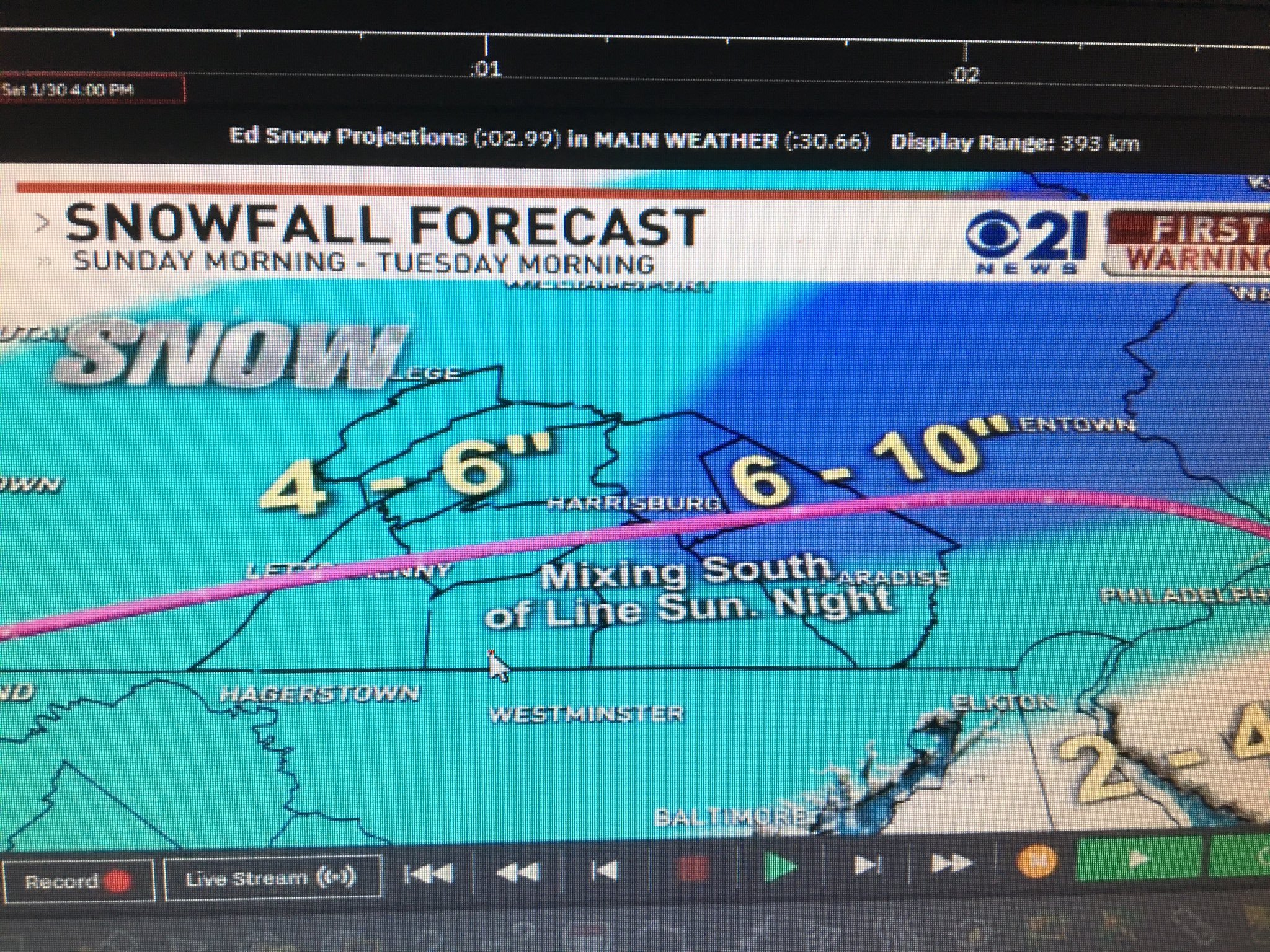
Here is Tom Russell (CBS 21) map.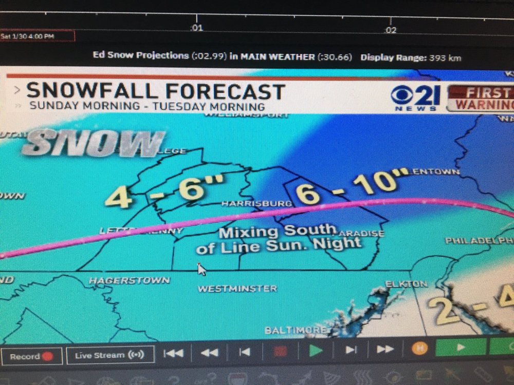
-
Central PA - Jan 31 to Feb 2 Winter Storm
canderson replied to MAG5035's topic in Upstate New York/Pennsylvania
How many DC weenies died looking at this? 20? -
Central PA - Jan 31 to Feb 2 Winter Storm
canderson replied to MAG5035's topic in Upstate New York/Pennsylvania
Yup! Some win, some “lose” but this beats the shit outta 2020 “winter.” -
Central PA - Jan 31 to Feb 2 Winter Storm
canderson replied to MAG5035's topic in Upstate New York/Pennsylvania
GFS kinda tells the NAM to step aside. -
Central PA - Jan 31 to Feb 2 Winter Storm
canderson replied to MAG5035's topic in Upstate New York/Pennsylvania
Understandable. The are too obscene for me to believe. I’ll take anything over 6” and be ecstatic! -
Central PA - Jan 31 to Feb 2 Winter Storm
canderson replied to MAG5035's topic in Upstate New York/Pennsylvania
Enjoy your 6-12”. That’s a great, great storm. -
Central PA - Jan 31 to Feb 2 Winter Storm
canderson replied to MAG5035's topic in Upstate New York/Pennsylvania
The RGEM gives Reading 51” snow. Gonna go out on a limb and say that model is trash.