

canderson
-
Posts
23,570 -
Joined
-
Last visited
Content Type
Profiles
Blogs
Forums
American Weather
Media Demo
Store
Gallery
Everything posted by canderson
-
Central PA - Winter 2021/2022
canderson replied to Bubbler86's topic in Upstate New York/Pennsylvania
Looks like I’ve hit 2” but I haven’t gone out to actually measure -
Central PA - Winter 2021/2022
canderson replied to Bubbler86's topic in Upstate New York/Pennsylvania
Sleet made it through VA quicker than forecast iirc. This system was a bust in parts of Tennessee too for some reason. Difficult storm for mets all along the eastern seaboard. Very odd system. Hopefully I can hang on this mod snow and get 4” -
Central PA - Winter 2021/2022
canderson replied to Bubbler86's topic in Upstate New York/Pennsylvania
Here is the yellow I am referencing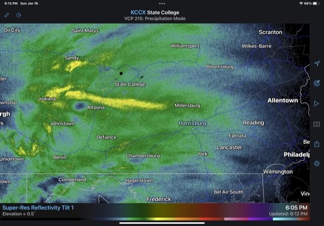
-
Central PA - Winter 2021/2022
canderson replied to Bubbler86's topic in Upstate New York/Pennsylvania
Yup wow. Lots of sleet out west according to RadarScope them. -
Central PA - Winter 2021/2022
canderson replied to Bubbler86's topic in Upstate New York/Pennsylvania
If it’s sleet then the atmosphere is all sorts of jacked up lol -
Central PA - Winter 2021/2022
canderson replied to Bubbler86's topic in Upstate New York/Pennsylvania
Was coming to ask about that. What’s the bright yellows on radar out west? -
Central PA - Winter 2021/2022
canderson replied to Bubbler86's topic in Upstate New York/Pennsylvania
Nearing 1”. Hoping this is a grower and not a shower storm. -
Central PA - Winter 2021/2022
canderson replied to Bubbler86's topic in Upstate New York/Pennsylvania
Pretty rare to get snow when it’s in the teens. Doesn’t happen that much for us. Wild this will flip to other things in 6 hours. -
Central PA - Winter 2021/2022
canderson replied to Bubbler86's topic in Upstate New York/Pennsylvania
Took all of 5 mins for everything to be white after snow started. -
Central PA - Winter 2021/2022
canderson replied to Bubbler86's topic in Upstate New York/Pennsylvania
Just checked the score - yikes. Hopefully SF-DAL is competitive cause the Steelers are going to get blown out. -
Central PA - Winter 2021/2022
canderson replied to Bubbler86's topic in Upstate New York/Pennsylvania
Saw that. I’m guessing he had a suicide wish and brought along his wife and child. Glad those two are safe and sound. -
Central PA - Winter 2021/2022
canderson replied to Bubbler86's topic in Upstate New York/Pennsylvania
Virga ongoing here now. BTW the river is iced over real nice. First time all year. -
Central PA - Winter 2021/2022
canderson replied to Bubbler86's topic in Upstate New York/Pennsylvania
They addressed this actually in the post I shared on the last page. I personally have no issues with them tweaking forecasts as they go. They’ve onky reply changed MDT 3 times - from 3-7, 3-5 and now 2-4. -
Central PA - Winter 2021/2022
canderson replied to Bubbler86's topic in Upstate New York/Pennsylvania
It’ll al be scattered when we wake up anyway lol -
Central PA - Winter 2021/2022
canderson replied to Bubbler86's topic in Upstate New York/Pennsylvania
You’re a bit over my prediction for MDT. I’m going with 2.9”. -
Central PA - Winter 2021/2022
canderson replied to Bubbler86's topic in Upstate New York/Pennsylvania
I was curious so I asked CTP about why there are no wind advisories. They had a great response: Chris Anderson When there is already a winter storm advisory or warning in effect for an area, there isn't a need/requirement to add another/separate advisory. At the point/time when the other warnings and advisories are/will not be in effect, then a wind advisory is recommended. Looking at the current forecast, this point is still 24+ hrs out for just a handful (3-4) counties. There is still time to discern whether or not the marginal wind gusts (forecast to be right at or just above 40KT) warrant issuance of a stand-alone wind advisory. If forecast confidence in a period of 40+KT gusts remains or increases for these 3 or 4 counties (and for the 3 to 6 hours such conditions might last after the winter headlines expire) we probably will do it. Gusty winds are already mentioned in much of the forecast information we have out there. -
Central PA - Winter 2021/2022
canderson replied to Bubbler86's topic in Upstate New York/Pennsylvania
CTP posted to Facebook… 520 AM 1/16/2022: A significant "Nor'Easter," one type of East Coast snowstorm (ECS), will affect the entire eastern seaboard today into Monday. Note the track/path of the center of the low pressure area (noted as a red "L" on the maps attached) will cross PA from south to north, likely just to the west of the Mainstem Susquehanna River. This track is usually one which allows a great deal of warm air to be drawn in from the Atlantic Ocean, and deeper (farther west) into PA. This results in much more mix precipitation and plain rain than would a track which would follow the NJ coast or the Delaware River. The track of the low has become much more certain over the past two days. Thus, any earlier forecasts which allowed for extreme amounts of snow over the Susq Valley are looking like they will not come to fruition. Usually, as we get closer to a (potential) storm, the forecasts improve in timing and precipitation type and amounts. This storm, and how the forecast has evolved over the last few days, is a good example of why we ask that you "stay tuned" and "check back for updates." This is especially true when there are many days to go before a storm could arrive. So, please do not latch on to the first forecast you see, especially if it is just a snowfall amount map. So many things can change regarding the interactions of all the meteorological conditions which influence a storm over the course of many days. -
Central PA - Winter 2021/2022
canderson replied to Bubbler86's topic in Upstate New York/Pennsylvania
5 degrees. Bet. -
Central PA - Winter 2021/2022
canderson replied to Bubbler86's topic in Upstate New York/Pennsylvania
CTP’s latest discussion is heavily focused in the dry slot. I’d rather have it than sleet and rain. -
Central PA - Winter 2021/2022
canderson replied to Bubbler86's topic in Upstate New York/Pennsylvania
No matter what happens tomorrow evening this system has been absolutely fascinating. Models have been uro is rock solid so if it is right major kudos). But we don’t see this type of thing much and it’s been interesting to watch develop. -
Central PA - Winter 2021/2022
canderson replied to Bubbler86's topic in Upstate New York/Pennsylvania
We do well with CAD but we can’t fight off a southerly influx. In 2019 we had a similar southerly flow than flipped snow to sleet and killed our expected 6”. We had 2.5” iirc of nearly all sleet. -
Central PA - Winter 2021/2022
canderson replied to Bubbler86's topic in Upstate New York/Pennsylvania
Warm air nearly always wins here - almost always. It’s why I don’t buy the euro. I’ll be pretty shocked if I get 3” snow/sleet before rain washes it mostly away. -
Western PA/Pittsburgh Winter 2021/22 Discussion
canderson replied to meatwad's topic in Upstate New York/Pennsylvania
Oops. I blame the beer. Drinking away the impending rainstorm. -
Western PA/Pittsburgh Winter 2021/22 Discussion
canderson replied to meatwad's topic in Upstate New York/Pennsylvania
Checking in from the east. Think you guys get hammered at our expense and that’s totally ok - Pittsburgh deserves a major snow. Enjoy! -
Central PA - Winter 2021/2022
canderson replied to Bubbler86's topic in Upstate New York/Pennsylvania
NAM appears to be a flat out tropical rain storm lol


