canderson
-
Posts
23,570 -
Joined
-
Last visited
Content Type
Profiles
Blogs
Forums
American Weather
Media Demo
Store
Gallery
Everything posted by canderson
-
Central PA - Winter 2021/2022
canderson replied to Bubbler86's topic in Upstate New York/Pennsylvania
Hah I didn’t mean the original - came across way too strong. We’ll get snow I’m sure but time is starting to tick. -
Central PA - Winter 2021/2022
canderson replied to Bubbler86's topic in Upstate New York/Pennsylvania
Just realized all my snow is gone - piles and all. Hope we get more - gonna be at least 10 days for a chance of a snowstorm it appears. -
Central PA - Winter 2021/2022
canderson replied to Bubbler86's topic in Upstate New York/Pennsylvania
CTP's noon discussion for the LSV really downplays any zr. Says any frozen precip will be sleet (my grid says less than half inch of sleet/snow and a whooooole lot of rain). Key part of disco: Total snow/sleet accumulations of 6+ inches are most likely across the NW mtns where a winter storm warning is probably needed with the next forecast cycle. The remainder of the CWA looks advisory worthy - however a rain to heavy sleet (0.5-2") scenario followed by a freeze-up can be just as or even more impactful than a straight warning level snow accumulation. We are most concerned about this type of outcome. -
Central PA - Winter 2021/2022
canderson replied to Bubbler86's topic in Upstate New York/Pennsylvania
My parents in Texas are in a winter storm watch. This is their forecast - they’ll get more winter weather than the LSV. In Dallas! Wednesday Night Rain before 9pm, then rain, freezing rain, and sleet between 9pm and 3am, then freezing rain and sleet after 3am. Low around 23. North wind 15 to 20 mph, with gusts as high as 30 mph. Chance of precipitation is 100%. New ice accumulation of 0.1 to 0.3 of an inch possible. New sleet accumulation of less than one inch possible. Thursday Snow and sleet likely, becoming all snow after 9am. Cloudy and cold, with a temperature falling to around 23 by 9am. Wind chill values between 8 and 17. North wind around 20 mph, with gusts as high as 30 mph. Chance of precipitation is 60%. New snow and sleet accumulation of 1 to 2 inches possible. Thursday Night A chance of flurries before midnight. Mostly cloudy, with a low around 17. North wind around 15 mph, with gusts as high as 25 mph. -
Central PA - Winter 2021/2022
canderson replied to Bubbler86's topic in Upstate New York/Pennsylvania
.5” zr is problematic. Very. -
Central PA - Winter 2021/2022
canderson replied to Bubbler86's topic in Upstate New York/Pennsylvania
In this solution, that's happy news. -
Central PA - Winter 2021/2022
canderson replied to Bubbler86's topic in Upstate New York/Pennsylvania
-
Central PA - Winter 2021/2022
canderson replied to Bubbler86's topic in Upstate New York/Pennsylvania
Might be some minor flooding issues in the LSV Thursday. That’s a lot of rain on frozen ground and a ice-packed river. -
Central PA - Winter 2021/2022
canderson replied to Bubbler86's topic in Upstate New York/Pennsylvania
Today last year we had a nice snowstorm. 10-12”. We had to drive to the emergency vet in the height of it, that sucked. -
Central PA - Winter 2021/2022
canderson replied to Bubbler86's topic in Upstate New York/Pennsylvania
-
Central PA - Winter 2021/2022
canderson replied to Bubbler86's topic in Upstate New York/Pennsylvania
CTP's forecast for Harrisburg. Wonder what the record amount of sleet is for this area? Thursday Night Rain before 4am, then rain and sleet. Low around 33. Chance of precipitation is 100%. New sleet accumulation of less than a half inch possible. Friday Sleet, possibly mixed with rain, snow, and freezing rain before 7am, then rain, snow, and freezing rain likely. High near 36. Chance of precipitation is 80%. -
Central PA - Winter 2021/2022
canderson replied to Bubbler86's topic in Upstate New York/Pennsylvania
I’m rooting for plain rain. This storm looks like a nightmare. -
Central PA - Winter 2021/2022
canderson replied to Bubbler86's topic in Upstate New York/Pennsylvania
If only it was mostly (or even a quarter) of snow …. I believe I’m reading thermals right and most is slept and zr, not actually snow
-
Central PA - Winter 2021/2022
canderson replied to Bubbler86's topic in Upstate New York/Pennsylvania
GFS is a bit colder for all of PA but still a huge ice and sleet fest it appears. -
Central PA - Winter 2021/2022
canderson replied to Bubbler86's topic in Upstate New York/Pennsylvania
Not officially but these transient events hardly ever - ever - work out for the LSV. -
Central PA - Winter 2021/2022
canderson replied to Bubbler86's topic in Upstate New York/Pennsylvania
Late week forecast is LOL. We never win these "flush out warm air in time for a good snow" events. Thursday Rain likely. Cloudy, with a high near 48. Chance of precipitation is 70%. New precipitation amounts of less than a tenth of an inch possible. Thursday Night Rain. Low around 34. Chance of precipitation is 90%. Friday Rain, snow, freezing rain, and sleet likely before 1pm, then a chance of snow and sleet between 1pm and 3pm, then a chance of snow after 3pm. Mostly cloudy, with a high near 44. Chance of precipitation is 60%. Friday Night Partly cloudy, with a low around 14. -
Model Mayhem Snowstorm! 2/2-2/4
canderson replied to BuffaloWeather's topic in Upstate New York/Pennsylvania
Chiming in from snow-starved Harrisburg. Excited to follow as you guys get hammered with this late week system. Jealous! -
Central PA - Winter 2021/2022
canderson replied to Bubbler86's topic in Upstate New York/Pennsylvania
Forecast high was 32. Currently 36. -
Central PA - Winter 2021/2022
canderson replied to Bubbler86's topic in Upstate New York/Pennsylvania
His Twitter account shows him living and dying on every individual model run. So he’s just another rando who likes weather. -
Central PA - Winter 2021/2022
canderson replied to Bubbler86's topic in Upstate New York/Pennsylvania
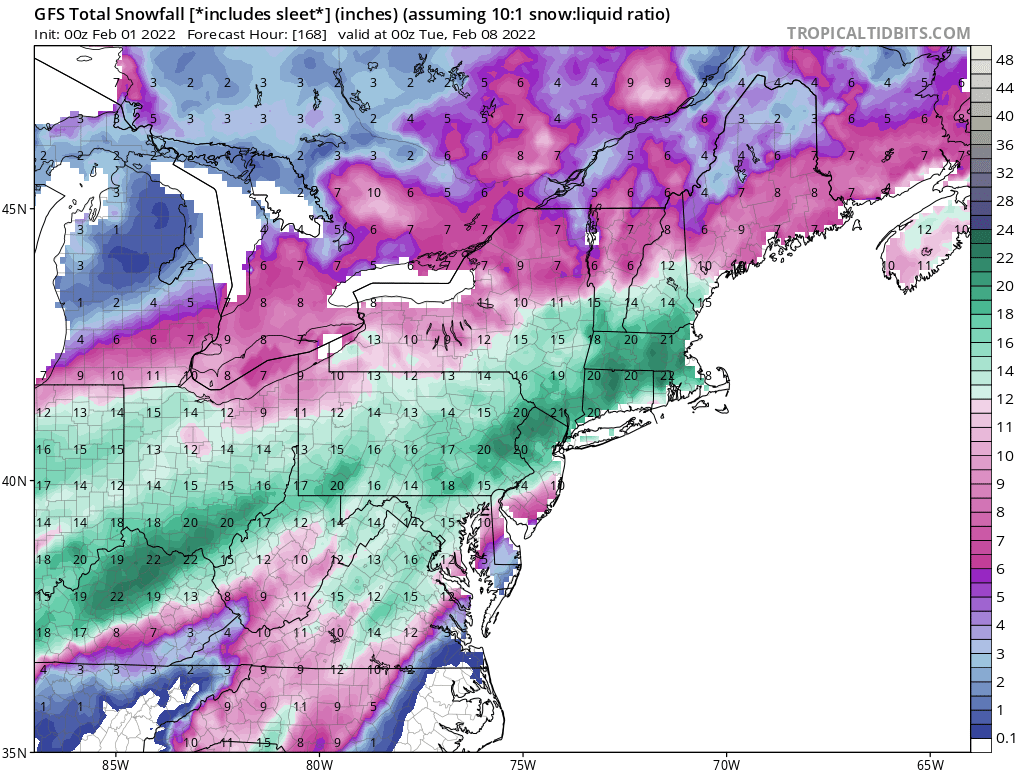
Upstate NY special. It’s been in the hairs for days. -
Central PA - Winter 2021/2022
canderson replied to Bubbler86's topic in Upstate New York/Pennsylvania
Euro appears to be a rainstorm for most everyone here. It’s a upstate NY crusher. Extreme northern PA gets some zr/sleet. Super amped. -
Central PA - Winter 2021/2022
canderson replied to Bubbler86's topic in Upstate New York/Pennsylvania
It's the North American JMA or whatever that garbage model is. -
Central PA - Winter 2021/2022
canderson replied to Bubbler86's topic in Upstate New York/Pennsylvania
Give me snow over tracking. Tracking fails nearly 80 percent of the time (if not more). -
Central PA - Winter 2021/2022
canderson replied to Bubbler86's topic in Upstate New York/Pennsylvania
Decent shot we get severe weather with this late eeek storm. I doubt any of us get snow but I can see it spinning some t storms. -
Central PA - Winter 2021/2022
canderson replied to Bubbler86's topic in Upstate New York/Pennsylvania
The river ice chunks are damn impressive on the Susky.