dryslot
-
Posts
60,469 -
Joined
-
Last visited
Content Type
Profiles
Blogs
Forums
American Weather
Media Demo
Store
Gallery
Everything posted by dryslot
-
Who's Brad Field?
-
Its going to be frozen of some sort, No way around it, Surface temps don't sniff 32°F
-
Seeing there wasn't an obs thread, I guess that's what we have.
-
I could post every 30 secs like most of the weenies in SNE do on these events if that would help the page count any.
-
That's ugly ice on the HRRR, Hopefully that's more IP the zr.
-
And that's the reason why its getting done, We have to load and pack tomorrow afternoon.
-
Its a roll of the dice generally, Some times its snake eyes.
-
Its getting cleared and let the chips fall where they may.
-
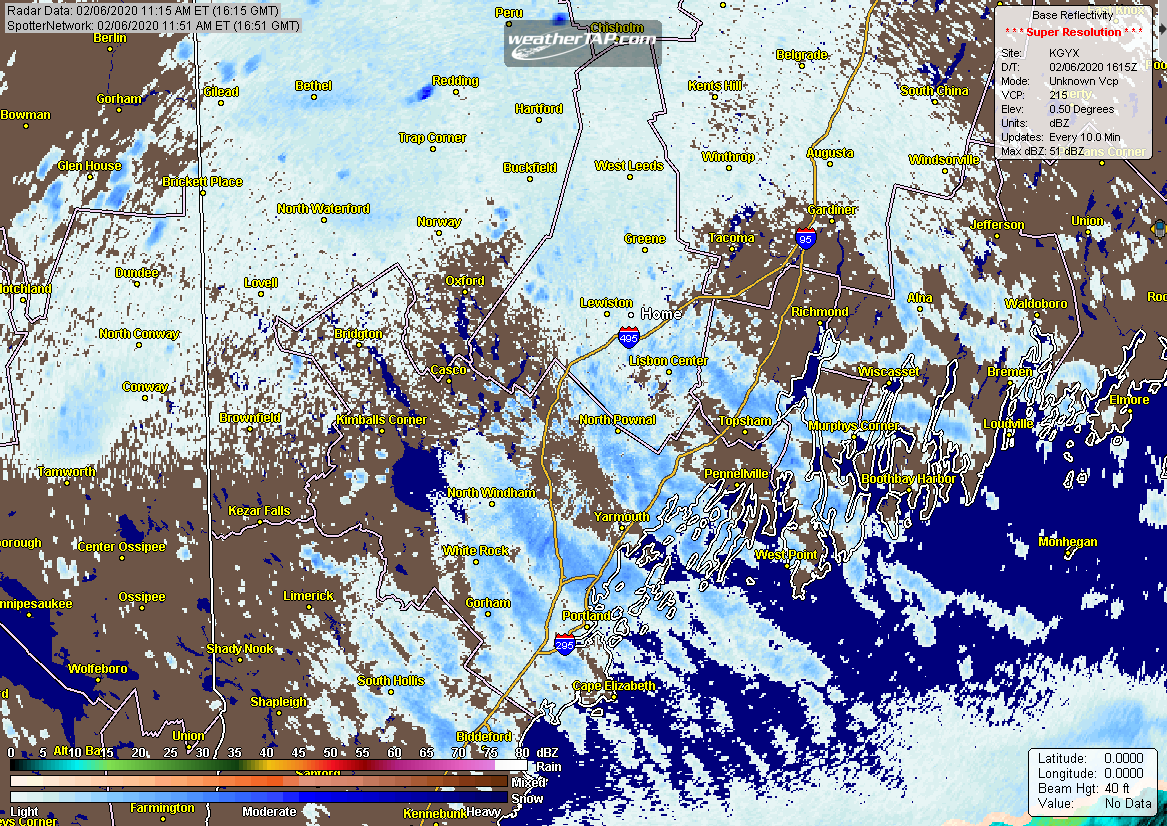
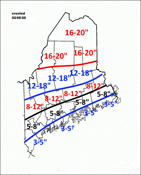
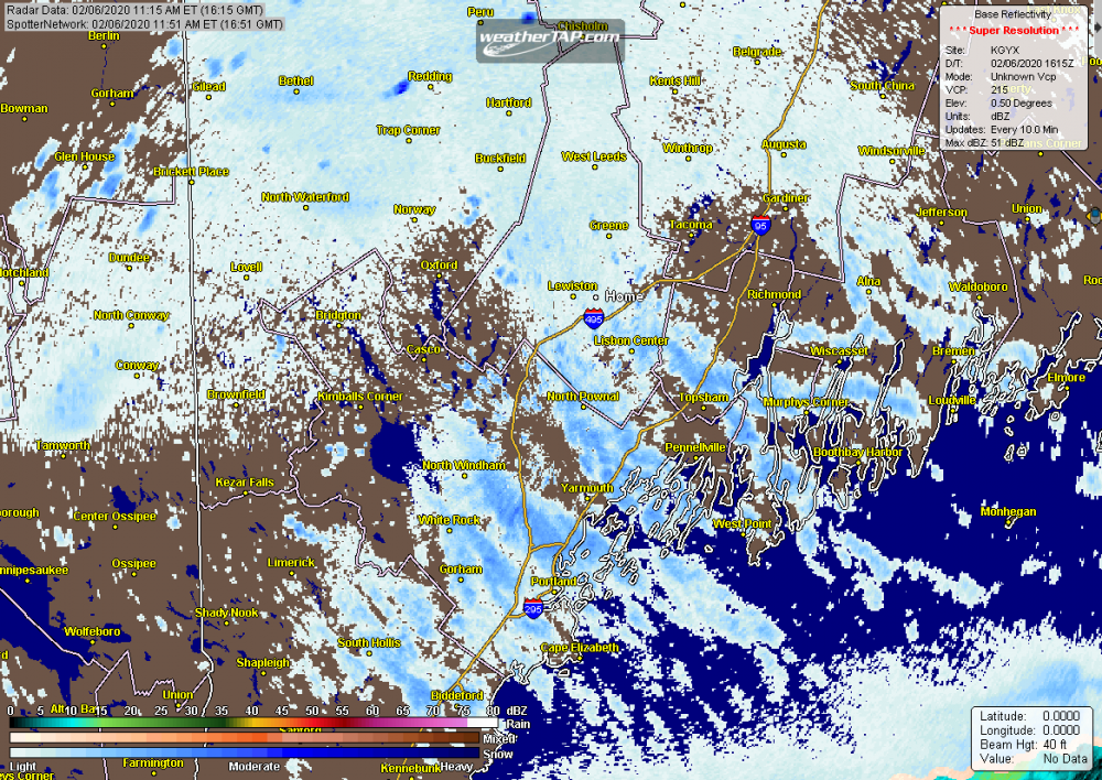
Some round 1 totals... 000 NOUS41 KGYX 061900 PNSGYX MEZ007>009-012>014-018>028-NHZ001>015-070700- Public Information Statement National Weather Service Gray ME 200 PM EST Thu Feb 6 2020 ...SNOWFALL REPORTS... Location Amount Time/Date Provider ...Maine... ...Androscoggin County... 4 S Turner 3.5 in 1153 AM 02/06 Trained Spotter 2 WNW Auburn 3.0 in 1220 PM 02/06 Trained Spotter 2 W Lisbon Falls 3.0 in 1256 PM 02/06 NWS Employee 2 E Lewiston 2.8 in 1148 AM 02/06 Trained Spotter ...Cumberland County... 2 SSW Cumberland 5.0 in 1253 PM 02/06 1 N Cumberland 5.0 in 0135 PM 02/06 Trained Spotter 3 ENE Westbrook 4.4 in 1004 AM 02/06 Trained Spotter Sebago 2.4 ESE 4.3 in 0900 AM 02/06 COCORAHS 1 SSW South Portland 4.1 in 0128 PM 02/06 Portland Jetport 4.0 in 1002 AM 02/06 ASOS Gray NWS Office 3.4 in 0100 PM 02/06 Official NWS Obs 1 SSW Brunswick 3.3 in 0125 PM 02/06 Trained Spotter Yarmouth 1.8 E 3.1 in 0800 AM 02/06 COCORAHS New Gloucester 3.0 in 0848 AM 02/06 Public 2 SE New Gloucester 2.9 in 1130 AM 02/06 2 WSW Falmouth 2.7 in 0805 AM 02/06 NWS Employee Falmouth 2.5 in 0802 AM 02/06 Public ...Franklin County... Weld 2.3 in 0906 AM 02/06 Public 1.0 W Kingfield 2.0 in 0830 AM 02/06 COOP Farmington 4.8 NNW 2.0 in 0900 AM 02/06 COCORAHS ...Kennebec County... Mount Vernon 2.5 in 0947 AM 02/06 Public 1 SE Augusta 2.1 in 0137 PM 02/06 Trained Spotter Clinton 1.8 in 1131 AM 02/06 Winthrop 1.5 in 0830 AM 02/06 UCOOP Winthrop 5.8 NE 1.3 in 0800 AM 02/06 COCORAHS ...Knox County... Hope 2.0 in 1147 AM 02/06 Trained Spotter ...Lincoln County... Westport Island 2.2 SSW 3.0 in 0800 AM 02/06 COCORAHS Waldoboro 1.5 NNE 2.0 in 0805 AM 02/06 COCORAHS ...Oxford County... Rumford 2.5 in 0822 AM 02/06 COOP Dixfield 9.0 S 2.2 in 0900 AM 02/06 COCORAHS Hartford 1.4 N 1.9 in 0832 AM 02/06 COCORAHS ...Waldo County... Belfast 14.2 W 1.5 in 0800 AM 02/06 COCORAHS ...York County... 2 SSW East Baldwin 4.2 in 1200 PM 02/06 Trained Spotter 2 ESE Goodwins Mills 4.1 in 1208 PM 02/06 Trained Spotter Kennebunk 3.8 in 1112 AM 02/06 Public 5 NW Hollis 3.6 in 1141 AM 02/06 NWS Employee Parsonsfield 3.9 NE 3.0 in 0800 AM 02/06 COCORAHS 2 NNW Saco 3.0 in 0131 PM 02/06 Trained Spotter 2 NE Kennebunk 2.9 in 0820 AM 02/06 Public
-
We could us a messenger shuffle if Scott can help us............
-
I don't even crack 32°F here.
-

Winter 2020 New England Banter and General Obs
dryslot replied to CapturedNature's topic in New England
Its fickle to say the least, Could have a long season, Could have a short one, But like he said, Can't make up for what time you lose once the sap changes in the tree. -
Most of the time convection porks us and looks like it will again.
-
I went with this here on the sled site i forecast on, I didn't want to mess with two maps so i just did a combined, That was before these continuous tics NW.
-
4" increments.
-
I feel like James with a little OES action going on
-
Yes, They have to use it, Waste of money or not or you get your budget cut then screwed the next winter if its a bad one and you run out of product before it ends.
-
Winter 2020 New England Banter and General Obs
dryslot replied to CapturedNature's topic in New England
Everyone shakes there head about how bad this winter has been and rightfully so, But when you have guys boiling sweet water to make maple syrup in early Feb, You know temps have been above normal. -
Lawn thread 2020 upcoming?
-
And unfortunately, There is more precip with wave 2, Got to love this winter..............
-
Wave 2 keeps ticking further NW ea model run, It can stop anytime now.
-
-SN, 19°F, 2.0" snow, First snow since 01/19, This winter has been rather lackluster.
-
The SLP for wave 2 has been getting stronger ea run too as it was in the 980mb range and is now low 970mb which is also causing this to track further west over SNE instead of off the coast
-
All the models have been amped and have tracked a few ticks west today at the surface, Not a good trend for coastal plain and the coast.
-
I'll send you a pic as i'm going by Saturday morning............