

Stormlover74
-
Posts
22,501 -
Joined
-
Last visited
Content Type
Profiles
Blogs
Forums
American Weather
Media Demo
Store
Gallery
Everything posted by Stormlover74
-

September 2019 General Discussions & Observations Thread
Stormlover74 replied to Rtd208's topic in New York City Metro
Today and tomorrow and then next friday thru Sunday all look at least low to mid 80s here -
September 2019 General Discussions & Observations Thread
Stormlover74 replied to Rtd208's topic in New York City Metro
Today and tomorrow and then next friday thru Sunday all look at least low to mid 80s here -
September 2019 General Discussions & Observations Thread
Stormlover74 replied to Rtd208's topic in New York City Metro
Looks like a nice but brief cooldown for midweek but next weekend looks hot again (mid 80s would be around 10 degrees above normal) -
September 2019 General Discussions & Observations Thread
Stormlover74 replied to Rtd208's topic in New York City Metro
Did I miss where today was supposed to be a washout? -
September 2019 General Discussions & Observations Thread
Stormlover74 replied to Rtd208's topic in New York City Metro
I mean technically yes but it only weakened by 5-10 mph from NC to NYC because it was mostly over the chesapeake. a track up the delaware river would've caused more wind damage -
September 2019 General Discussions & Observations Thread
Stormlover74 replied to Rtd208's topic in New York City Metro
Irene didn't really track inland. It made landfall in NC as cat 1 and was still a cat 1 when it hit AC. Like every hurricane that takes a track like that the highest winds will always stay out over water or hit LI. Of course my block was the only place that managed to have a tree come down and take out power lines but I think that had more to do with the incredibly saturated ground since the highest gusts were only 50-55 mph -
I remember when I was 4 we had what was left of hurricane David in 1979. I'm not sure I knew what a hurricane was or why we would name them but I could see the rain blowing down the street sideways and the man on the radio saying to stay away from the windows
-
September 2019 General Discussions & Observations Thread
Stormlover74 replied to Rtd208's topic in New York City Metro
Hard to believe this is a little over 30 hours from now -
March 2010 was probably more intense
-
September 2019 General Discussions & Observations Thread
Stormlover74 replied to Rtd208's topic in New York City Metro
Yep -
September 2019 General Discussions & Observations Thread
Stormlover74 replied to Rtd208's topic in New York City Metro
82/68 but with the breeze it doesn't feel that bad -
September 2019 General Discussions & Observations Thread
Stormlover74 replied to Rtd208's topic in New York City Metro
Like every mid September to early October of late. As soon as someone says the heat is over it always comes roaring back -
We hadn't had a nor'Easter like that in at least a decade
-
September 2019 General Discussions & Observations Thread
Stormlover74 replied to Rtd208's topic in New York City Metro
The gfs just found out yesterday it was going to get hot this week -
September 2019 General Discussions & Observations Thread
Stormlover74 replied to Rtd208's topic in New York City Metro
It would be the following weekend like the 22nd-23rd -
September 2019 General Discussions & Observations Thread
Stormlover74 replied to Rtd208's topic in New York City Metro
Definite overperforming day today. Forecasts were mostly 73-75 but its now up to 80 across much of interior nj -
Apparently Seattle's getting a thunderstorm
-
September 2019 General Discussions & Observations Thread
Stormlover74 replied to Rtd208's topic in New York City Metro
and practically nothing falling for most of DE and the jersey shore -
September 2019 General Discussions & Observations Thread
Stormlover74 replied to Rtd208's topic in New York City Metro
Some moisture finally beginning to push onshore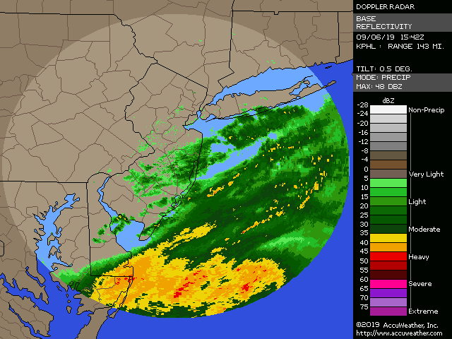
-
September 2019 General Discussions & Observations Thread
Stormlover74 replied to Rtd208's topic in New York City Metro
I'm thinking this may not verify Steve d -
September 2019 General Discussions & Observations Thread
Stormlover74 replied to Rtd208's topic in New York City Metro
With mostly sun today Ewr made it to 90 -
Today looks like a bust down here.
-
September 2019 General Discussions & Observations Thread
Stormlover74 replied to Rtd208's topic in New York City Metro
Quite rainy. Upton had a chance of showers with a likelihood this afternoon. -
September 2019 General Discussions & Observations Thread
Stormlover74 replied to Rtd208's topic in New York City Metro
Had the same thing pretty sure its traffic related -
Have to use tapatalk


