Stormlover74
-
Posts
22,464 -
Joined
-
Last visited
Content Type
Profiles
Blogs
Forums
American Weather
Media Demo
Store
Gallery
Everything posted by Stormlover74
-
That's kinda what we said last year then we got our 2 best storms in mid February and then winter ended
-
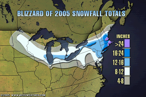
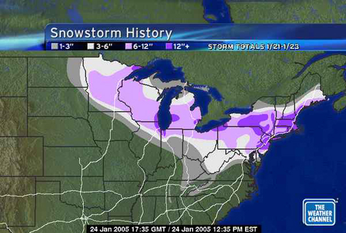
20 years since the blizzard of 2005. A great underrated storm that dumped 12 to 18" with higher amounts east and even saw blizzard conditions the following morning as the low bombed off the coast Temps were around 10 at the start and the snow came in like a wall with 8 hours of S+ I spent much of it driving back from a basketball game in Philly and it was surreal being on 95 with almost no other cars
-

1/21-1/22 Winter Storm OBS Thread
Stormlover74 replied to metalicwx367's topic in Southeastern States
Based off the earthcam myrtle beach looks to have gone over to sleet...or at least a mix -
Just cleared out here so should start dropping more quickly
-
1/21-1/22 Winter Storm OBS Thread
Stormlover74 replied to metalicwx367's topic in Southeastern States
Not sure if this is the record but certainly one of the biggest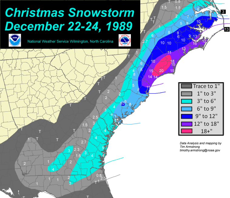
-
Yes I see the hrrr increased amounts too. Looks like 6 to 9 for my parents in Conway
-
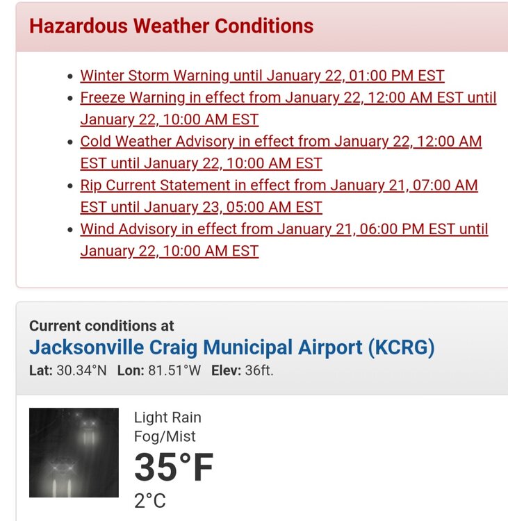
Not that it matters because we all know it's cold but it's interesting everywhere west of us has a cold weather advisory including all of Mt Holly's counties but upton didn't issue one for any part of their area
-
Southern snow and weather balloons
-
Upton With a very strong part of the jet stream overhead, known as a jet streak, our weather balloon this evening measured 203 knots (234 mph) at 250 mb (around 33,000 ft)! A 200+ knot wind has only been measured during 10 other launches from our site, dating back to 1952.
-
https://www.earthcam.com/usa/southcarolina/myrtlebeach/?cam=myrtlebeach_hd
-
All that's missing is a tornado
-
At this point I'd take a cutter with 1 to 2" of rain rather than cold and dry
-
It's probably akin to us having a blizzard on October 15th
-
My parents in SC are expecting anywhere from 1 to 8 depending on which forecast/model you look at
-
Local TV meteorologists deliver tearful farewell as stations replace staff with The Weather Channel feed https://www.cnn.com/2025/01/21/media/local-meteorologists-allen-media-weather-channel/index.html
-
Newark got 11" then 6 hours of heavy sleet. Then a flip to rain before a changeover back to snow with 3" on top. It was like cement that didn't melt for a week If it was all snow 24-28" would've been likely as they got 2.75" of liquid
-
Central Park sticks out like a sore thumb
-
Wonder if the city can drop into the single digits during this outbreak. It looks close but forecasted lows seem to be a bit higher than they were a few days ago
-
Same I had over 4 in the grass but my patio table only had 3 or so. Other measurements were in between and averaged to 3.5
-
But most places in your 3 to 6 verified
-
In line with forecasts. Maybe a little below. I think we get something in March when nobody wants it
-
I don't think there was much of a screw zone. The graupel mixing in during the heavier precip for the first few hours may have hurt us a bit. There were a few isolated amounts over 4" but most of the 5+ was from Hunterdon over through Morris and west Essex on north and west. Generally it was 3 to 4 south of 78 and dropped off once south of us by 20 or 30 miles.
-
Yeah I think we're done for a week but euro and gfs both have something early next week with borderline temps. Or possibly later in the week. Would be nice to have my seasonal totals over a foot heading into February
-
Nice steady snow falling again
-
Looks like one last burst perhaps