cheese007
-
Posts
1,633 -
Joined
-
Last visited
Content Type
Profiles
Blogs
Forums
American Weather
Media Demo
Store
Gallery
Everything posted by cheese007
-
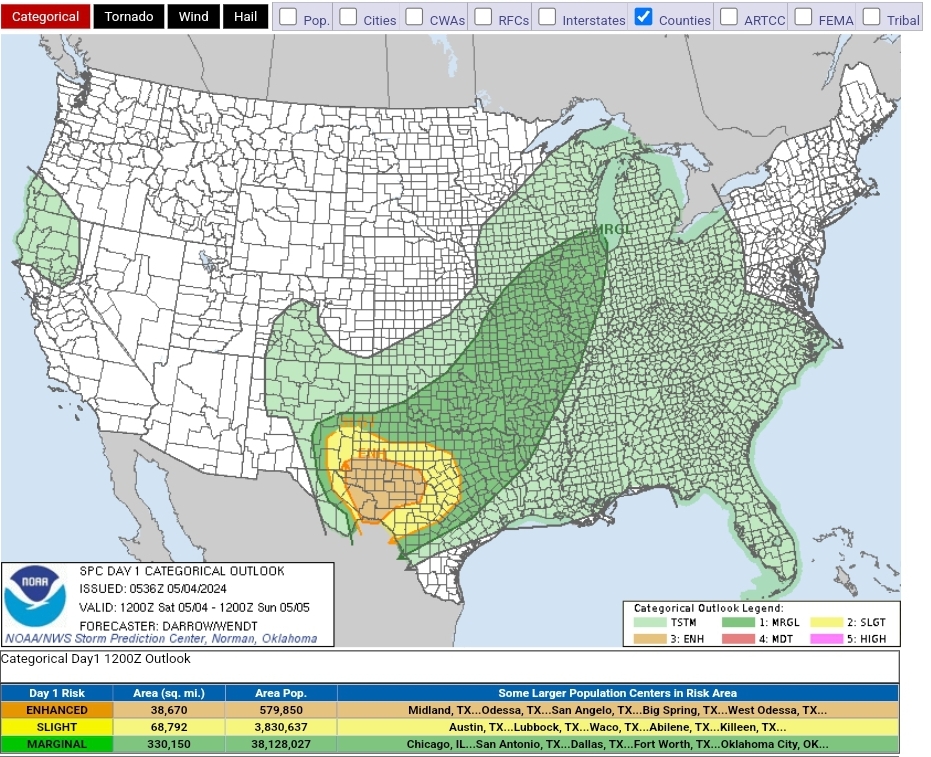
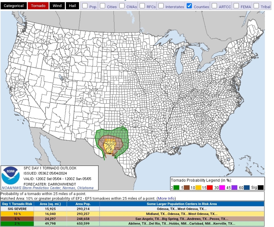
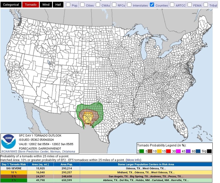
D1 ENH with a 10% sigtor hatch on tap for today Day 1 Convective Outlook NWS Storm Prediction Center Norman OK 1236 AM CDT Sat May 04 2024 Valid 041200Z - 051200Z ...THERE IS AN ENHANCED RISK OF SEVERE THUNDERSTORMS ACROSS PARTS OF THE SOUTHERN HIGH PLAINS INTO THE EDWARDS PLATEAU... ...SUMMARY... Scattered severe thunderstorms are expected across parts of the southern High Plains into the Hill Country of central Texas this afternoon and evening. Several storms may produce very large hail, and a couple strong tornadoes are possible. ...Southern High Plains to the Hill Country of TX... Water-vapor imagery depicts a low-amplitude short-wave trough off the Baja Peninsula. This feature will advance across northern Mexico by early evening as a 500mb speed max translates toward the Big Bend of west TX, subsequently moving into central TX by 05/12z. A reservoir of very moist/unstable air will reside across south TX/Edwards Plateau into portions of west TX. Robust convection will easily develop ahead of the short wave and quickly become severe during the afternoon. Very large hail and the threat for tornadoes can reasonably be expected. Early this morning, surface pressures are building across the central Plains in the wake of ejecting northern-stream short-wave trough. Surface front will surge across the TX South Plains early in the period, and will likely arc along/near I-20 into southeast NM by 18z. Latest model guidance suggests strong boundary-layer heating will occur ahead of the wind shift across far west TX into the Trans Pecos. Forecast soundings, south of the front, suggest surface parcels will reach their convective temperatures by 20z, just east of the dryline. This feature will be forced deep into west TX and will be one of the foci for convective development, along with the cold front. Latest NAM PFC for INK at 20z exhibits MLCAPE on the order of 3500 J/kg with surface-6km bulk shear around 45kt. Scattered supercells will likely develop by mid afternoon and quickly attain severe levels. This activity will grow upscale and shift downstream, aided by the progressive short wave. In response to the short wave, LLJ is forecast to focus across west TX through early evening then strengthen and shift east toward the I-35 corridor by sunrise Sunday. Initial convective mode will be supercellular and very large hail can be expected. Additionally, moistening boundary layer will support tornadoes, possibly strong, as shear will be strong. With time, MCS is expected to mature and propagate toward central TX during the overnight hours. ..Darrow/Wendt.. 05/04/2024

-
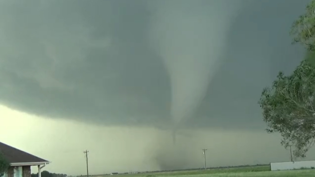
Jesus that thing has an eye on radar
-
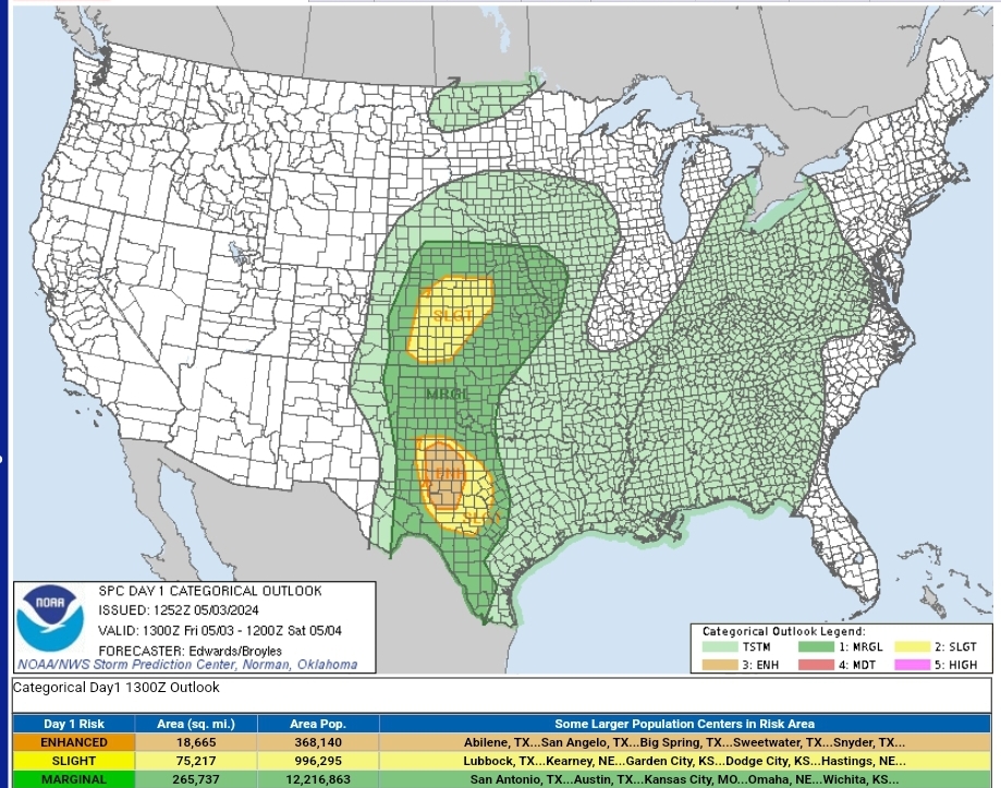
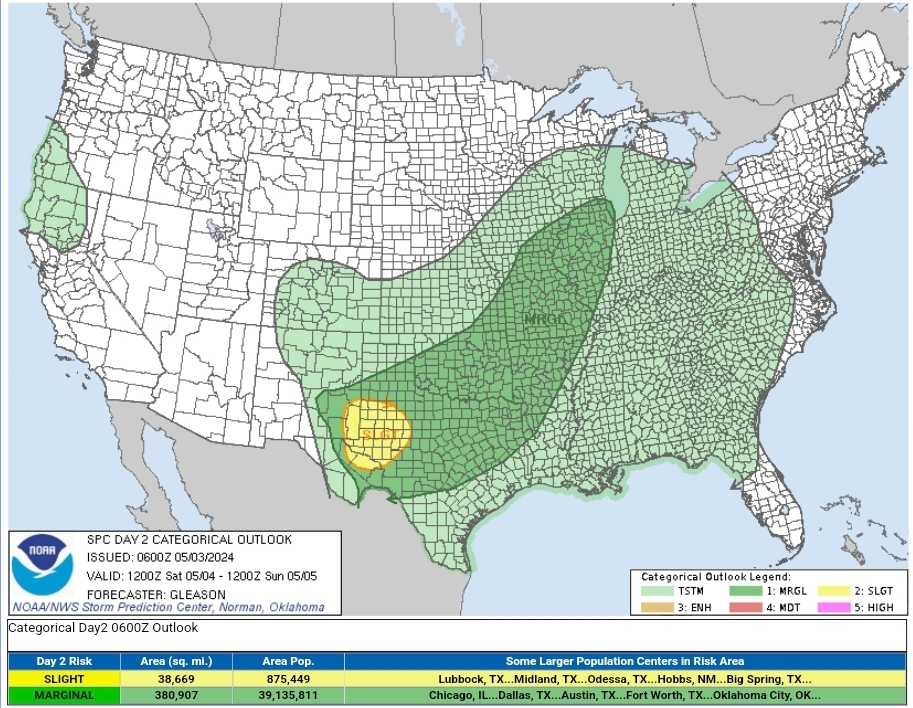
Bi-modal D1 risk with the southern section upgraded to ENH. D2 slight for the Permian Basin area Day 1 Convective Outlook NWS Storm Prediction Center Norman OK 0752 AM CDT Fri May 03 2024 Valid 031300Z - 041200Z ...THERE IS AN ENHANCED RISK OF SEVERE THUNDERSTORMS FROM NEAR THE WEST TEXAS CAPROCK ONTO ADJOINING LOW ROLLING PLAINS... ...THERE IS A SLIGHT RISK OF SEVERE THUNDERSTORMS SURROUNDING THE ENHANCED AREA...AND OVER PORTIONS OF THE CENTRAL PLAINS... ...SUMMARY... Large hail and damaging gusts are possible over parts of the central/southern Great Plains from southern Nebraska to west Texas, along with some tornado potential over parts of west Texas. ...Synopsis... Today's transitional mid/upper-level synoptic pattern is a tale of two cyclones -- one astride the Upper Midwest/Canadian border, and another digging southeastward out of the Gulf of Alaska. The broad, complex leading cyclone will eject northeastward over MB and northwestern ON through the period. A trailing shortwave trough -- apparent in moisture-channel imagery over parts of southern ID and northern NV -- will move east-northeastward to eastern SD and central NE by 12Z tomorrow. The strong, well-developed Pacific cyclone will proceed southeastward to just off the coast of OR by the end of the period. Southwest flow aloft will be maintained with weak synoptic-scale height rises over most of the central/southern Plains. Still, sufficient moisture, buoyancy, lift and shear are apparent for a couple relative maxima in severe potential as discussed below. At the surface, 11Z analysis showed a low attached to a cold front over south-central WY. The front should proceed southeastward through the day, extending from southeastern SD to western NE an central CO by 00Z, with the low over northeastern CO. By 12Z tomorrow, the front should extend from a low over IA to south- central KS, the northern TX Panhandle, and north-central NM. This front will overtake a developing dryline over the central High Plains from north-south, with the dryline position at 00Z over eastern CO, the western TX Panhandle, and Permian Basin. A weak/ residual, nearly stationary front extended from a low near FST northeastward across northwest TX, eastern OK and the Ozarks, and should continue to lose definition amidst considerable convective outflow. The southern rim of that outflow was evident from southeast TX (between GLS-BPT) across the HOU metro then west- northwestward to near SJT. The western part will shift northward slowly through the day toward the front, which itself should drift northward up the Caprock. ...West/southwest TX... Widely scattered to scattered thunderstorms are expected to form this afternoon near the dryline and the residual outflow boundary over the South Plains to Low Rolling Plains/Concho Valley regions. Isolated to widely scattered convection possible farther south off the dryline past the Rio Grande, and into strongly heated/CINH- minimized higher terrain of the Serranias del Burro range in northern Coahuila. This activity should move eastward across areas below the Caprock and around the Big Country to Edwards Plateau, with potential for some of the Mexican convection to cross the Rio Grande this evening as well. Supercells -- with large to very large hail and at least isolated potential for tornadoes -- will be more probable in and near the 30%/"enhanced" hail area. Dryline and orographic activity to the south will be an early hail/wind threat. Some of this activity may aggregate into clusters offering mainly strong-severe gusts, with one or two small MCSs possible this evening into the early overnight hours. Despite multiple days of MCS and smaller-scale convective activity to the east and southeast, a reservoir of rich low-level moisture remains not far upstream across south-central TX and into the southern Edwards Plateau, where upper 60s to low 70s F surface dewpoints and PW commonly 1-1.5 inches. When advected northwestward amid diurnal heating and beneath steep midlevel lapse rates, 3000-4000 J/kg MLCAPE should become common. Though low-level flow should not be particularly strong, it will be backed, contributing to elongated hodographs ad around 30-40 kt effective-shear magnitudes. Splitting storms may be common early, offering the greatest hail potential (size and coverage). The damaging-wind threat will be maximized on the mesoscale where organized cold pools can develop, and should extend farther east at greater density than the hail potential this evening into tonight. In the absence of substantial large-scale support, tornado potential will be locally maximized with any supercells that can interact favorably with outflow boundaries or each other. ...Central Plains... Large hail and severe gusts are possible from mid/late afternoon into tonight, from thunderstorms shifting eastward across portions of the central Plains. Though nowhere nearly as moist as the TX outlook area, a diurnally destabilized plume of moist advection should support a secondary relative max in severe potential along/ahead of the cold front and dryline from parts of eastern CO to western/northern KS and southern NE. Convection should develop by mid/late afternoon in a regional convergence maximum near and northeast of the surface low, with MLCINH weakened by favorable diurnal heating. Surface dewpoints in the 40s to low 50s F should be common, with steep surface-500-mb lapse rates, 500-1000 J/kg MLCAPE and well-mixed subcloud layers. Effective-shear magnitudes around 40-50 kt indicate potential for organized convection -- both in quasi-linear form near the front and initially discrete (but later merging upscale) off the dryline. Though activity will encounter a more-stable boundary layer with time and eastward extent across KS/NE, at least marginal severe-gust potential may last overnight as far eastward as parts of the Missouri Valley region. ..Edwards/Broyles.. 05/03/2024 Day 2 Convective Outlook NWS Storm Prediction Center Norman OK 0100 AM CDT Fri May 03 2024 Valid 041200Z - 051200Z ...THERE IS A SLIGHT RISK OF SEVERE THUNDERSTORMS ACROSS PARTS OF WEST TEXAS AND SOUTHEASTERN NEW MEXICO... ...SUMMARY... Scattered severe thunderstorms posing a threat for very large hail, damaging winds, and perhaps a few tornadoes should occur across parts of the southern High Plains Saturday afternoon and evening. Isolated strong to severe thunderstorms may occur across a broader portion of the southern Plains into the Ozarks, mid Mississippi Valley, and Midwest. ...Synopsis... A closed upper low will move east-southeastward over the western states on Saturday. Downstream, a shortwave trough will advance quickly east-northeastward across the Upper Midwest through the day. A related weak surface low should develop from IA towards IL in the same time frame. A cold front will extend southwestward from this low across parts of the mid MS Valley into the southern Plains. A subtle/low-amplitude shortwave trough is forecast to move across northern Mexico and the southern High Plains by late Saturday afternoon. This feature may provide sufficient lift to support isolated to scattered severe thunderstorms across parts of the southern High Plains Saturday afternoon/evening. ...Southern High Plains... A weak surface low should be in place over parts of far west TX and north-central Mexico through the day, with a dryline extending southward from this low. A southward-moving cold front should eventually intersect the dryline by late Saturday afternoon. Diurnal heating of a very moist low-level airmass and steep mid-level lapse rates will contribute to moderate/locally strong instability across west TX and southeastern NM. Convective initiation appears likely along both boundaries Saturday afternoon and evening. Although low-level flow should remain rather weak through the day, a favorably veering and slowly strengthening wind profile with height through mid levels will support around 35-45 kt of deep-layer shear. Robust thunderstorms that develop should quickly become supercellular and pose a threat for very large hail. Occasional severe/damaging downdraft winds may also occur. The tornado threat should be modulated to some extent by weak low-level flow and modest 0-1 km shear through much of the afternoon. Still, a few tornadoes appear possible towards Saturday evening with any persistent supercell as an easterly low-level jet strengthens. A Slight Risk has been introduced across parts of west TX and southeastern NM where confidence is greatest in supercells occurring. ...Midwest/Mid Mississippi Valley to the Ozarks/Southern Plains... A line of strong to locally severe thunderstorms may be ongoing at the start of the period Saturday morning along or just ahead of the cold front, extending from IA into eastern KS. Even with a nocturnal minimum in instability, occasional damaging winds may occur with this line before it eventually weakens by late morning. Eventual redevelopment appears probable across parts of the mid MS Valley/Midwest by Saturday afternoon, as daytime heating ahead of the front fosters weak to moderate MLCAPE. Deep-layer shear appears marginal to support organized convection (around 25-30 kt). But, some small clusters may consolidate and pose an isolated threat for damaging winds and hail as they spread eastward across parts of the Midwest through Saturday afternoon, before slowly weakening Saturday evening with the loss of daytime heating. There also appears to be some chance for convection across west TX to spread eastward across much of OK/TX Saturday evening/night as the weak shortwave trough continues eastward across these areas. With moderate to strong MUCAPE present along/south of the cold front, some of this activity could pose a continued threat for isolated severe hail and gusty winds. ..Gleason.. 05/03/2024
-
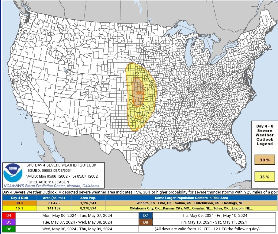
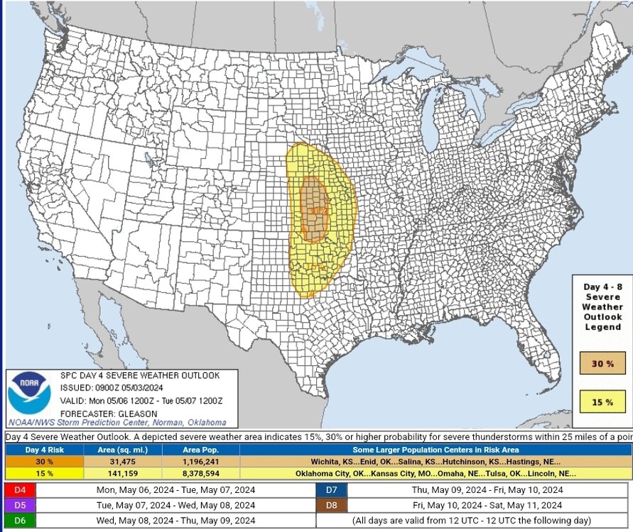
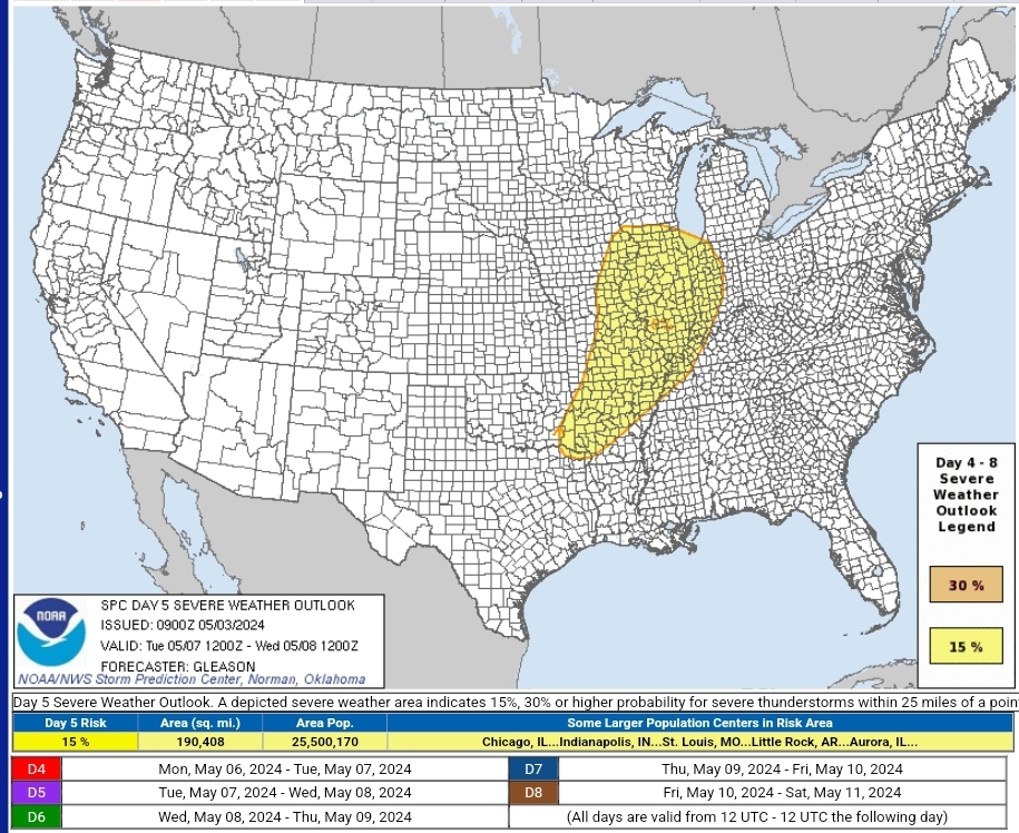
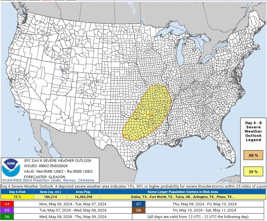
Gonna be a busy week next week Day 4-8 Convective Outlook NWS Storm Prediction Center Norman OK 0400 AM CDT Fri May 03 2024 Valid 061200Z - 111200Z ...SEVERE WEATHER OUTBREAK POSSIBLE ON D4/MON... ...DISCUSSION... A multi-day period of organized severe thunderstorm potential appears likely across parts of the central to eastern CONUS next week, beginning on Day 4/Monday across the Plains, and continuing through at least Day 6/Wednesday. ...Day 4/Monday... A negatively tilted upper trough will eject northeastward over the northern/central Plains on Monday. Pronounced low-level mass response will encourage rich low-level moisture to advect northward over the southern/central Plains, as a surface low rapidly deepens over the northern High Plains. Strong deep-layer shear and at least moderate instability are expected to be in place ahead of a surface dryline extending across the southern/central Plains. Thunderstorms will likely erupt along the length of the dryline by late Monday afternoon from southern NE into central KS and north-central OK. Supercells are likely to be the dominant mode initially given the strength of the deep-layer shear. Both very large hail and tornadoes will be possible with these supercells as they spread eastward across the southern/central Plains through Monday evening. With a southerly low-level jet forecast to strengthen to at least 50-60 kt Saturday evening, a corresponding rapid increase in low-level shear will likely support a continued threat for tornadoes with any discrete convection. Some of these tornadoes could be strong. The severe threat will likely continue Monday night with eastward extent across the Plains, before convection possibly weakens some towards early Tuesday morning. Given increased confidence in high-end severe potential, a 30% severe area has been introduced from parts of southern NE into central KS and north-central OK. ...Day 5/Tuesday... The large-scale upper trough/low is forecast to gradually occlude over the northern Plains on Tuesday. But, an enhanced mid-level jet and embedded vorticity maximum will likely overspread parts of the Upper Midwest, mid MS Valley, and OH Valley through Tuesday evening. An expansive warm sector will likely be in place across these regions ahead of a surface cold front/dryline. Robust convection should develop along/ahead of these boundaries through the day. Sufficient instability and deep-layer shear will likely exist to support organized severe thunderstorms, including supercells posing a threat for all severe hazards. The northeastward extent of the warm sector remains somewhat uncertain into the OH Valley. Still, some severe risk will probably persist into Tuesday evening/night with eastward extent across the mid MS Valley and lower OH Valley/Midwest. Expansion of the 15% severe area may be needed in later outlooks, pending better model agreement and increased confidence in the eastward extent of rich low-level moisture and related instability. ...Day 6/Wednesday... The upper trough/low should gradually evolve eastward across the northern Plains on Wednesday. While there are still some differences in model guidance regarding the evolution of an embedded shortwave trough, there appears to be enough agreement in the synoptic pattern to include a 15% severe delineation for Wednesday for parts of the southern Plains into the ArkLaTex/Ozarks and towards the mid MS Valley. Across these areas, strong instability is forecast to develop east of a front/dryline. With enhanced mid-level flow persisting with a westerly mid/upper-level jet, organized severe thunderstorms should once again develop Wednesday afternoon. Supercells posing a threat for all severe hazards may occur. The northern/eastern extent of the severe threat is unclear, as the convection from Tuesday may tend to limit better low-level moisture return into the OH/TN Valleys. Depending on model trends over the next few days, the 15% severe area may need to be expanded to include these regions. ...Day 7/Thursday and Day 8/Friday... Some severe threat may continue on Thursday from parts of TX into the lower MS Valley/Southeast, generally along/south of a front and any convection that develops Wednesday. Too much uncertainty currently exists to include a 15% severe area at this time, but trends will be monitored. A severe risk also appears possible next Friday across the same general regions, but confidence in the placement of the front and convection is even lower than Thursday. ..Gleason.. 05/03/2024
-
Severe Weather 4-30-24 through 5-2-24
cheese007 replied to cstrunk's topic in Central/Western States
Gonna be a very close call for Abilene if this can put another tor down -
Severe Weather 4-30-24 through 5-2-24
cheese007 replied to cstrunk's topic in Central/Western States
Nice tor on the Abilene storm on Bob Pack's stream
-
What do you mean it's totally correct
-
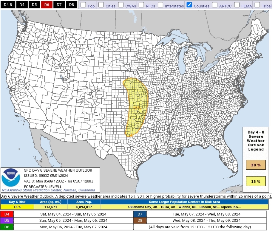
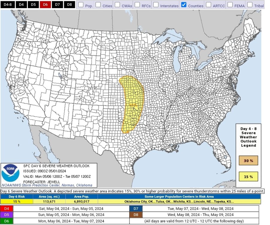
SPC has highlighted a swath of the plains from TX to NE for D6. May is in full swing! Day 4-8 Convective Outlook NWS Storm Prediction Center Norman OK 0403 AM CDT Wed May 01 2024 Valid 041200Z - 091200Z ...DISCUSSION... For Saturday/D4 to Sunday/D5, scattered to perhaps numerous thunderstorms are possible over a large section of the CONUS from the southern Plains into the Southeast. Mid 60s F to lower 70s F dewpoints will be common across the entire area, aided by southerly surface winds around an East Coast high. Aloft, generally weak flow will exist over the same areas, well east of a developing western upper trough. As such, the weak shear will likely minimize overall severe potential through Sunday/D5. For Monday/D6, models have shown increased run-to-run consistency in depicting a deep upper trough developing over the Great Basin and emerging into the Plains. Rich low-level moisture will be in place ahead of this system, which is forecast to enter the central Plains with a negative tilt and strong shear. While minor trough-geometry differences exist amongst the models, the combination of strengthening shear, a potentially deep surface low and ample moisture and instability necessitate introducing severe probabilities for parts of the Plains on Monday. All facets of severe appear possible with such a system, including supercells, squall lines, tornadoes, damaging winds and large hail. ..Jewell.. 05/01/2024
-
Severe Weather 4-30-24 through 5-2-24
cheese007 replied to cstrunk's topic in Central/Western States
Had at least a brief tor on it per spotter -
Severe Weather 4-25 through 4-28-24
cheese007 replied to cheese007's topic in Central/Western States
-
Severe Weather 4-25 through 4-28-24
cheese007 replied to cheese007's topic in Central/Western States
Dickson might get round 2 -
Severe Weather 4-25 through 4-28-24
cheese007 replied to cheese007's topic in Central/Western States
About to get tor number 3 -
Severe Weather 4-25 through 4-28-24
cheese007 replied to cheese007's topic in Central/Western States
Might be about to be hit again -
Severe Weather 4-25 through 4-28-24
cheese007 replied to cheese007's topic in Central/Western States
Bryce Shelton and Brett Adair have different angles of a massive wedge that went through Minden -
Severe Weather 4-25 through 4-28-24
cheese007 replied to cheese007's topic in Central/Western States
https://livestormchasing.com/chasers/brett.adair Stunning shot on Brett's stream -
Severe Weather 4-25 through 4-28-24
cheese007 replied to cheese007's topic in Central/Western States
Just took out the News 6 camera at the airport in Omaha -
Severe Weather 4-25 through 4-28-24
cheese007 replied to cheese007's topic in Central/Western States
https://www.ketv.com/nowcast lowering on the Omaha cell -
Severe Weather 4-25 through 4-28-24
cheese007 replied to cheese007's topic in Central/Western States
Freddy McKinney has a clear-ish shot -
Severe Weather 4-25 through 4-28-24
cheese007 replied to cheese007's topic in Central/Western States
Lucio has the storm that made the wedge. Tor still on the ground https://livestormchasing.com/chasers/null -
Severe Weather 4-25 through 4-28-24
cheese007 replied to cheese007's topic in Central/Western States
HUGE wedge on Vince Waeiti's stream (forum wont let me link it) -
Severe Weather 4-25 through 4-28-24
cheese007 replied to cheese007's topic in Central/Western States
https://livestormchasing.com/chasers/mike.prendergast stream of TX tor -
Severe Weather 4-25 through 4-28-24
cheese007 replied to cheese007's topic in Central/Western States
confirmed tor south of West, TX -
Severe Weather 4-25 through 4-28-24
cheese007 replied to cheese007's topic in Central/Western States
ENH expanded southward with sigtor hatching added -
Severe Weather 4-25 through 4-28-24
cheese007 replied to cheese007's topic in Central/Western States
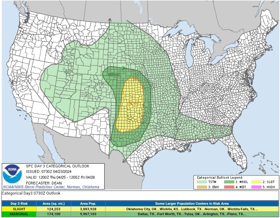
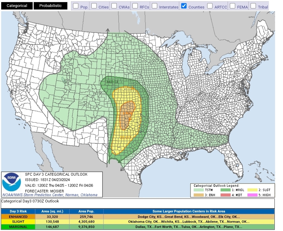
Thursday bumped up to ENH SPC AC 231831 Day 3 Convective Outlook AMEND 1 NWS Storm Prediction Center Norman OK 0131 PM CDT Tue Apr 23 2024 Valid 251200Z - 261200Z ...THERE IS AN ENHANCED RISK OF SEVERE THUNDERSTORMS FROM THE EASTERN TX PANHANDLE AND WESTERN OK INTO SOUTHWEST/SOUTH-CENTRAL KS... AMENDED TO UPDATE FORECAST ...SUMMARY... Severe thunderstorms are likely from late Thursday afternoon into Thursday night across parts of the central and southern Great Plains. Very large hail, severe wind gusts, and strong tornadoes will all be possible. Guidance continues to suggest strong buoyancy will be in place ahead of a negatively tilted shortwave trough ejecting across the southern High Plains. General forecast expressed in the previous outlook remains valid, but confidence in an area of greater severe-weather potential has become more apparent with the most recent guidance. Late afternoon development is anticipated across the TX Panhandle, with these storms quickly becoming severe and capable of large to very large hail up to 3" in diameter. Low-level moisture may be later to arrive in west-central/southwest KS, delaying convective initiation to a few hours later than farther south. Large to very large hail is anticipated with initial development across west-central/southwest KS as well. In both of these areas, storms are expected to move east-northeastward off the dryline, encountering strengthening low-level southerly flow and environment that is increasingly favorable for tornadoes. Low-level shear will continue to strengthening into the early evening, and the overall environment supports the potential for strong to intense tornadoes if a discrete mode can be maintained.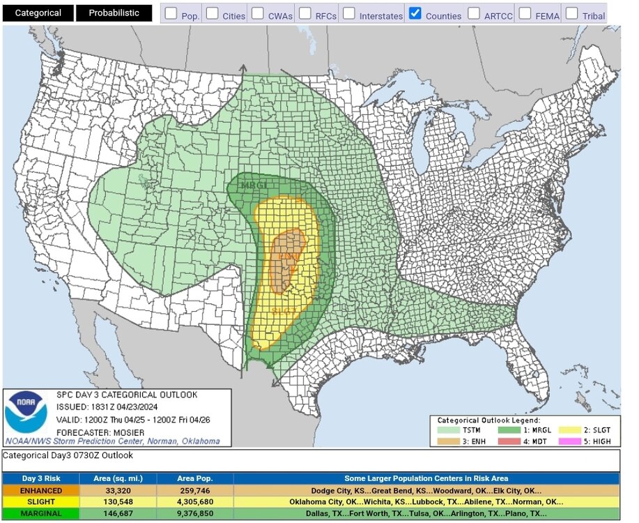
-
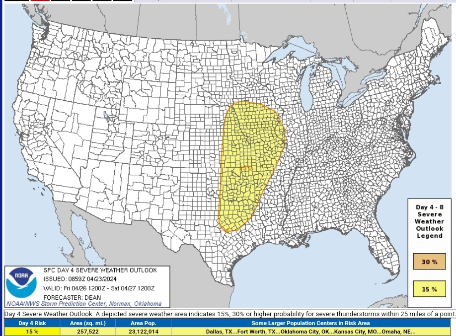
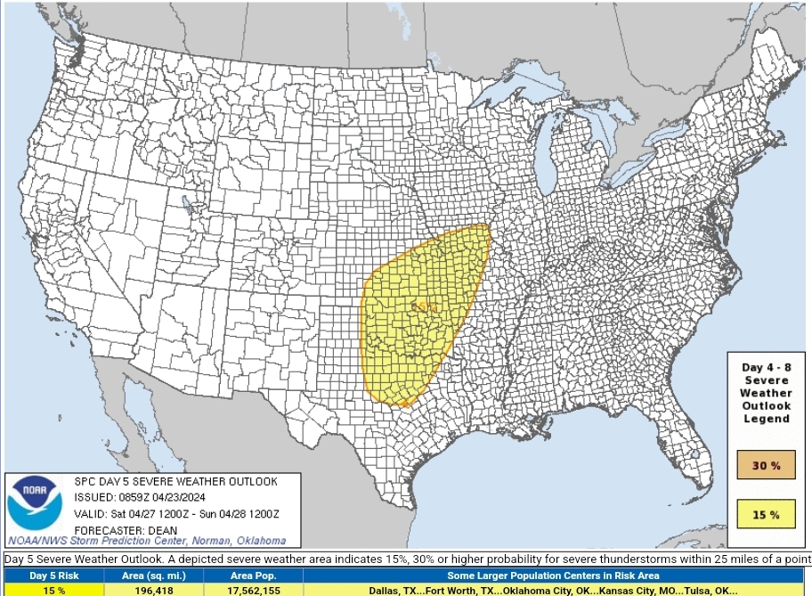
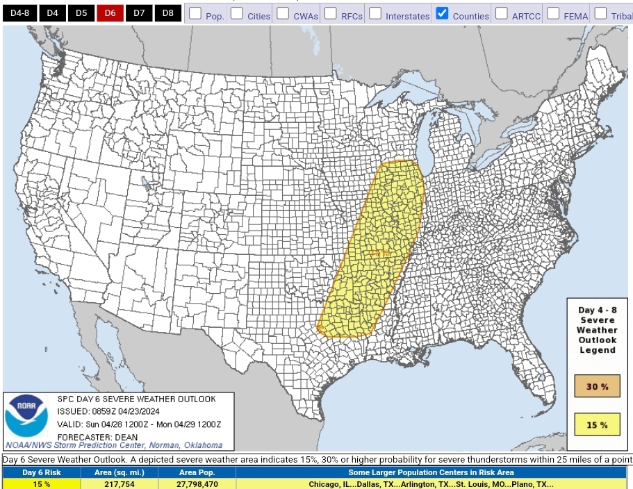
Active few days on the plains starting Thursday. At a glance looks kinda messy for tor potebtial but something to watch SPC AC 230730 Day 3 Convective Outlook NWS Storm Prediction Center Norman OK 0230 AM CDT Tue Apr 23 2024 Valid 251200Z - 261200Z ...THERE IS A SLIGHT RISK OF SEVERE THUNDERSTORMS FOR PARTS OF THE SOUTHERN AND CENTRAL GREAT PLAINS... ...SUMMARY... Severe thunderstorms may develop late Thursday afternoon into Thursday night across parts of the central and southern Great Plains. Large hail, severe wind gusts, and a few tornadoes will all be possible. ...Synopsis... A shortwave trough initially over the Southwest is forecast to take on an increasingly negative tilt as it moves eastward towards the central/southern Plains by Thursday night into Friday morning. In response, a surface low will consolidate and deepen across the central High Plains through the day, before moving northeastward toward northwest KS/southwest NE by Friday morning. An initially stationary surface boundary will move northward as a warm front across the central Plains through the day. Along/south of the warm front, relatively rich low-level moisture will stream northward to the east of a dryline that will become established from the eastern TX Panhandle into western KS and eastern CO. ...Southern/central Great Plains... Coverage of the severe-thunderstorm threat remains somewhat uncertain, but a couple intense supercells are possible by Thursday evening near the dryline from western KS into western OK and the TX/OK Panhandles. Another round of overnight convection will potentially bring the severe threat eastward into a larger portion of the central/southern Plains. The warm sector of the deepening cyclone will likely remain capped for much of the day, though elevated convection may persist from parts of central/eastern KS into eastern OK, to the north of the effective warm front. Increasing moisture beneath steep midlevel lapse rates will support MLCAPE in excess of 2000 J/kg along/east of the dryline, as deep-layer shear strengthens across the region through the day. Ascent attendant to the approaching shortwave trough will begin to impinge upon the warm sector by late afternoon, with isolated supercell development possible near the surface low across southwest KS and southward down the dryline into the TX Panhandle. Very large hail (potentially 2-3 inches in diameter) will likely be the primary initial hazard. A notable increase in low-level flow/shear near and after 00Z will also support a tornado threat with any supercells that can persist into the evening across parts of western KS/OK. While any initial dryline storms may weaken by mid/late evening due to increasing MLCINH with eastward extent, renewed storm development is possible overnight along the Pacific cold front from southwest TX into western/central KS/OK as stronger large-scale ascent overspreads the region. Steep midlevel lapse rates, moderate buoyancy, and strong low-level and deep-layer shear will conditionally support a severe threat with overnight convection across the warm sector, though storm mode may become complex and tend toward a linear evolution with time. Severe wind gusts may become an increasing threat with the nocturnal convection, though hail and a couple tornadoes will also be possible if semi-discrete or embedded supercells can be maintained. ...NE/WY border region into northeast CO... Low-level southeasterly flow will support modest moisture return into parts of northeast CO, southeast WY, and western NE, to the north of the deepening cyclone. Thunderstorm development will be possible near and to the cool side of the effective warm front during the afternoon. While deep-layer shear will be weaker compared to areas farther southeast, steep midlevel lapse rates will support an isolated hail threat. A tornado also cannot be ruled out, if surface-based storms can be maintained within this regime. ..Dean.. 04/23/2024 ZCZC SPCSWOD48 ALL ACUS48 KWNS 230859 SPC AC 230859 Day 4-8 Convective Outlook NWS Storm Prediction Center Norman OK 0359 AM CDT Tue Apr 23 2024 Valid 261200Z - 011200Z ...DISCUSSION... A complex but active pattern is expected from D4/Friday through D6/Sunday, as multiple mid/upper-level shortwave troughs impinge upon a moist and unstable environment extending from the southern/central Great Plains into parts of the Midwest and Mississippi Valley. ...D4/Friday - Central/southern Plains into the mid MS Valley... A negatively tilted shortwave trough is forecast to move northeastward from the Great Plains toward the mid/upper MS Valley on Friday. Most guidance suggests that convection developing late in the D3/Thursday period will be ongoing Friday morning, potentially posing an organized severe threat as it moves eastward. The influence of early convection on warm sector evolution by Friday afternoon/evening remains uncertain, but in general, moderate destabilization will be possible along the Pacific front/dryline in the wake of early convection, with some intensification of early storms also possible farther east. Details regarding storm mode remain uncertain at this forecast range, but in general, severe storms capable of producing large hail, damaging winds, and a few tornadoes will be possible across a broad region from the eastern Great Plains into the mid MS Valley. ...D5/Saturday - Central/southern Plains into the Midwest/mid MS Valley... The negatively tilted shortwave trough and attendant occluding surface cyclone are forecast to gradually weaken as they move across the upper Great Lakes region on Saturday. Depending on timing of the departing cyclone and magnitude of diurnal destabilization, some severe-thunderstorm threat could evolve in advance of this system through the afternoon across parts of WI/IL into MI, but confidence remains too low to include 15% probabilities for this area. Meanwhile, another strong shortwave trough is forecast to eject across parts of the central/southern Plains Saturday afternoon and evening, accompanied by strong surface cyclogenesis across the central High Plains. Moderate to locally strong instability may redevelop along/east of the dryline across central/western KS/OK into north TX, as low-level and deep-layer shear strengthen through the day. The synoptic pattern depicted by much of the extended-range guidance is suggestive of an active severe thunderstorm episode along/ahead of the dryline, though some guidance (notably recent runs of the ECMWF) suggest potential for early development across parts of OK/north TX, which could complicate the scenario by late afternoon/evening. Some severe threat could spread toward parts of the mid MS Valley late in the period. ...D6/Sunday - ArkLaTex into parts of the Midwest... Predictability begins to decrease by late in the weekend, though in general, a mid/upper-level trough and attendant surface low are forecast to move from the central Plains toward the upper Great Lakes region. A corridor of severe thunderstorm potential is forecast to extend south-southwestward from the surface low, as a trailing cold front moves through a moist, unstable, and favorably sheared environment. A 15% area has been added where confidence is currently greatest in severe-thunderstorm potential Sunday afternoon and evening. ..Dean.. 04/23/2024