PackGrad05
-
Posts
1,778 -
Joined
-
Last visited
Content Type
Profiles
Blogs
Forums
American Weather
Media Demo
Store
Gallery
Everything posted by PackGrad05
-

February 19-20 Major Winter Storm Threat
PackGrad05 replied to NorthHillsWx's topic in Southeastern States
Balloon data will greatly improve model consistency as we get into tonight and tomorrow morning . -
February 19-20 Major Winter Storm Threat
PackGrad05 replied to NorthHillsWx's topic in Southeastern States
Focus on impacts also. The January system was 5-6 hours of precip for central Nc and caused multiple days of impacts with lingering cold temps at night . -
February 19-20 Major Winter Storm Threat
PackGrad05 replied to NorthHillsWx's topic in Southeastern States
The last system trended weaker in this timeframe and everyone jumped ship. Then it came back within 24-48 hours of the start. Also, this could be high impact regardless. Especially with ice. . -
February 19-20 Major Winter Storm Threat
PackGrad05 replied to NorthHillsWx's topic in Southeastern States
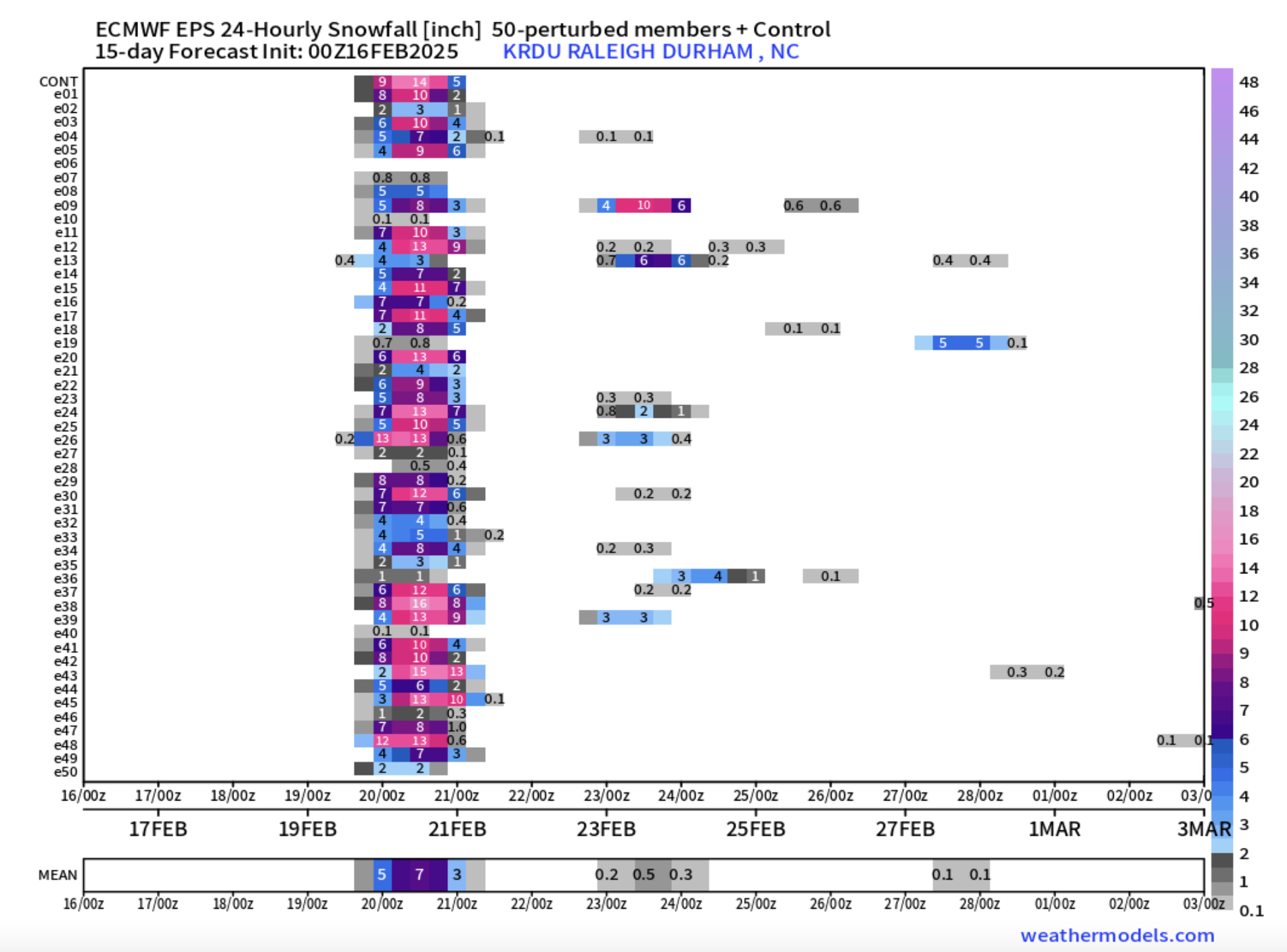
That graphic is only snow amount impacts. Ice would extend much further south . -
February 19-20 Major Winter Storm Threat
PackGrad05 replied to NorthHillsWx's topic in Southeastern States
NWS Raleigh posted this on Facebook with regards to 00z euro: “However, I'm concerned that model may be overdone, given the strong jet streak aloft that may bring in some dry air and push the storm to the northeast rather fast late Wed evening. Both of those would tend to limit overall precip amounts. So perhaps leaning toward the GFS which features less overall precip may be the better way to lean at this particular moment. But of course it's the weather, and things can change either way. It's worth keeping in mind that even the lesser GFS amounts are still impactful to central NC. It doesn't take much wintry precip to cause problems here in this part of the country. Stay tuned!” . -
February 19-20 Major Winter Storm Threat
PackGrad05 replied to NorthHillsWx's topic in Southeastern States
However, this is a much different setup. We seem to be focusing on snow, but it is going to be a huge impact event regardless of precip type. Also, I can't remember the last time the EPS looked like this, this close to the event.
-
February 19-20 Major Winter Storm Threat
PackGrad05 replied to NorthHillsWx's topic in Southeastern States
A weaker system may mean less QPF, but it also means better chance of snow for central NC... vs. a strong system that pulls warm air into the mid levels -
February 19-20 Major Winter Storm Threat
PackGrad05 replied to NorthHillsWx's topic in Southeastern States
Current trends are good but common in this range... Beware of the models going back the other direction to correct a little bit. Common theme... I'm still predicting a mixed bag of ice and cold rain for central NC until I see a few more days of these trends -
At this point (8 days away), it's useless looking at specifics. The pattern is there and that's all that matters.
-
Not all the piedmont. NW Portions.
-
HRRR shows a burst of sleet/freezing rain for RDU Tuesday morning
-
Euro with the classic I-85 signature. After the northwest trend, only the mountains will get anything.
-
Temperatures will definitely warm up. And it will seem "warmer than normal" simply because of how cold it has been. We still have a week of January and the whole month of February. Lots of time.
-
Really nice band setting up along I-95 from Florence to Fayetteville.. moving north.
-
Looks like it’s going to end for wake about 1-2 hours earlier than expected. About an inch here in willow springs. Grass barely poking through .
-
RDU is a poor way to represent Wake County as a whole anyway. RDU is on the very west edge of a county that is 857 square miles. This could easily be a scenario where Garner/Fuquay, etc... see way more than RDU.
-
If I'm local mets, I wouldn't change my forecast much. I'm still going 0-1" for I-85 to Wake, 1-2" for Johnston County east, perhaps 2-3" near the coast
-
GFS was nice.
-
FWIW, the 00Z HRRR was about 50-75 miles west with the edge than 18Z
-
Mike maze just posted the euro ensembles increased. .
-
Watch euro and EPS come back west.
-
The suppression is not the only reason. The storm is less amped and stayed too positive tilt to really ramp up and move north. The path is there if it strengthens .
-
Both euro and eps shifted NW. I’m surprised folks here have given up unless I’m the only one in southeast wake or east of that. Still going to be some pretty snow falling and might surprise some folks. .
-
New blend .
-
Still expecting a trace to half inch for southeast portions of wake and into joco .