PackGrad05
-
Posts
1,778 -
Joined
-
Last visited
Content Type
Profiles
Blogs
Forums
American Weather
Media Demo
Store
Gallery
Everything posted by PackGrad05
-

Mid to Long Range Discussion ~ 2023
PackGrad05 replied to buckeyefan1's topic in Southeastern States
Friday isn't looking quite as bad for RDU based on the track of the low (further north and west). That's a good thing but got to keep monitoring. -
Mid to Long Range Discussion ~ 2023
PackGrad05 replied to buckeyefan1's topic in Southeastern States
The last 2 runs of the EPS have been a nice look for March 9 - 13 time period. -
Mid to Long Range Discussion ~ 2023
PackGrad05 replied to buckeyefan1's topic in Southeastern States
The 00Z EPS really likes the 11-13 time period... Still watching that. Also watching severe potential for Friday. -
Mid to Long Range Discussion ~ 2023
PackGrad05 replied to buckeyefan1's topic in Southeastern States
Turned my attention to March 9-11 now. -
Mid to Long Range Discussion ~ 2023
PackGrad05 replied to buckeyefan1's topic in Southeastern States
Both the latest EPS and GEFS have members showing snow for RDU around 3/4. The EPS has been consistent with it (50% of members or less) for the past couple days. -
Mid to Long Range Discussion ~ 2023
PackGrad05 replied to buckeyefan1's topic in Southeastern States
EPS seems to be trying to sniff something out around the beginning of March. GEFS starting to bite as well. -
Mid to Long Range Discussion ~ 2023
PackGrad05 replied to buckeyefan1's topic in Southeastern States
23rd - 27th looks interesting? -
SREF Link https://www.spc.noaa.gov/exper/sref/srefplumes/ Just now coming into range.
-
Definitely a westward trend. The good thing is we still have a few days.
-
-
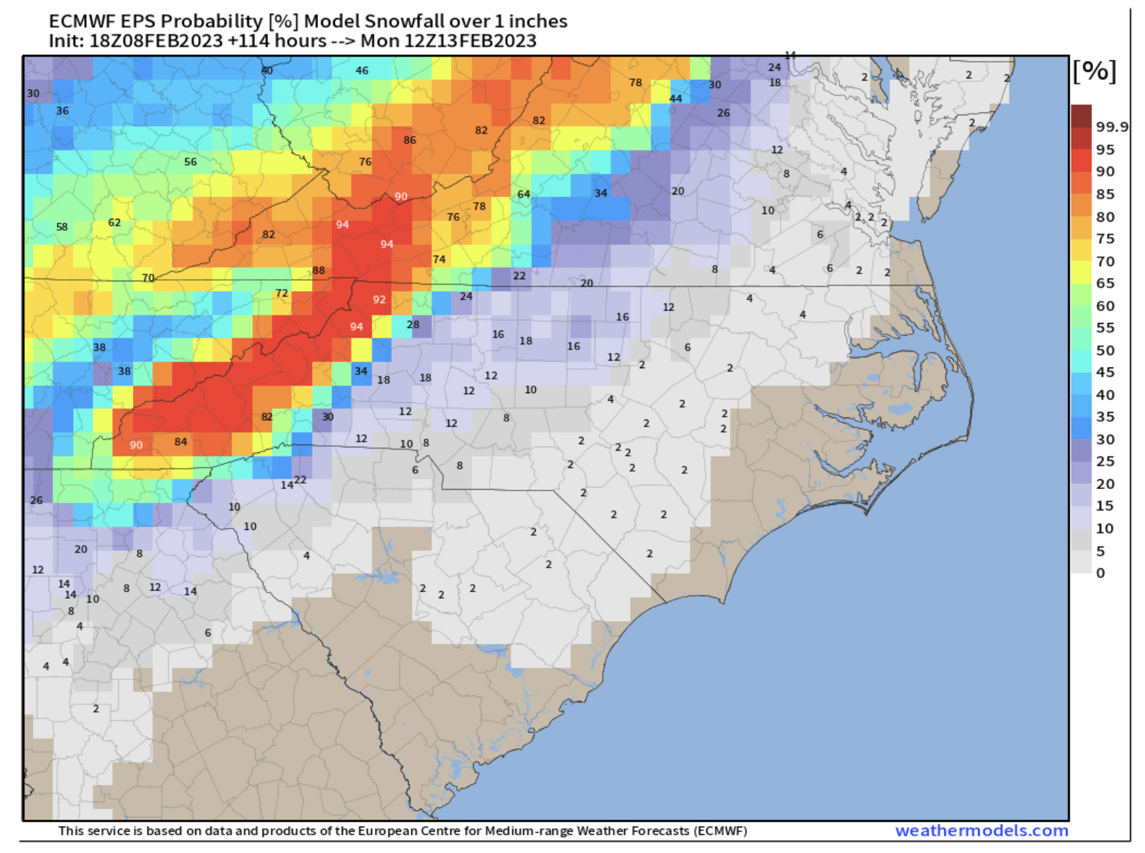
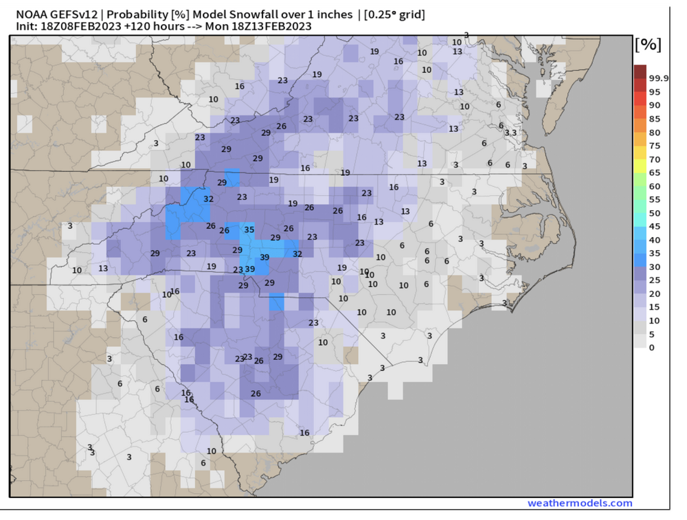
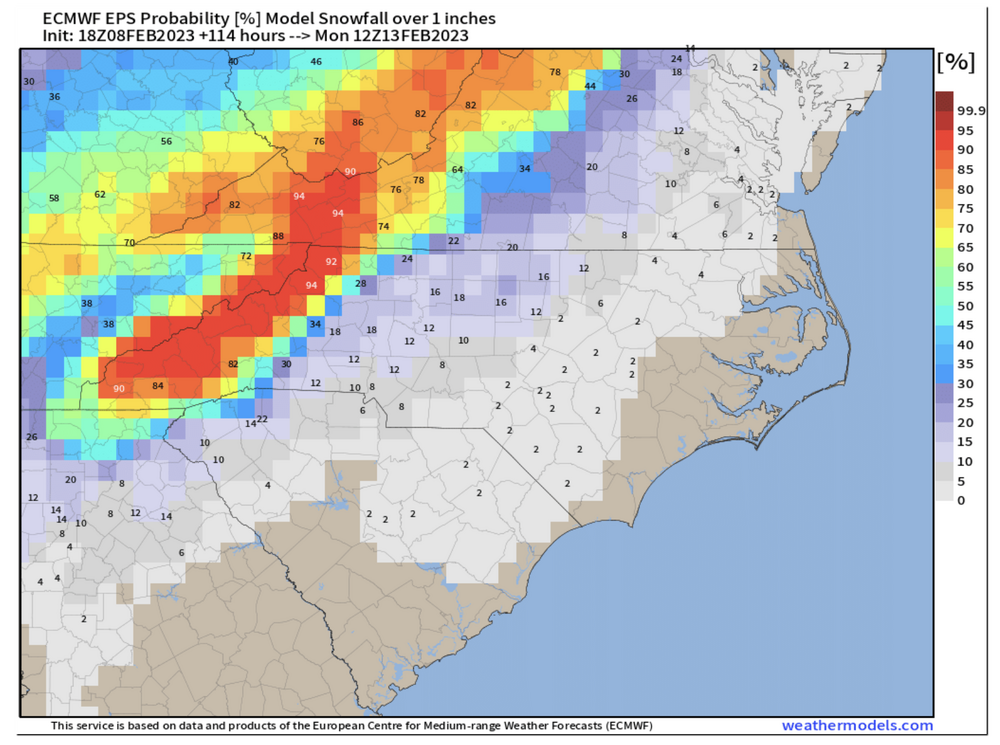
Here are the 18Z EPS and GEFS probabilities of 1" of snowfall.
-
The placement of the low looks good on the NAM to me.
-
Correct. I looked at snowfall, not snow depth. But the way this season has been, I'd love to see a snow fall, even if it doesn't stick!
-
The probability of 1" or greater improved on both the GEFS and EPS (12Z) as compared to previous runs...for most of central NC. Still low, but good trends.
-
GFS isn't good for Raleigh, but there is still time... and I'm waiting on the GEFS too.
-
Mid to Long Range Discussion ~ 2023
PackGrad05 replied to buckeyefan1's topic in Southeastern States
00Z EPS still has a decent chance, but not as good as yesterday's 12Z run. Does anyone know how to view the 06Z EPS on weathermodels.com? I have premium. 06Z GEFS trended in the right direction also and shows a greater chance. Neither is a slam dunk of course... at least it is something to track for once. -
Mid to Long Range Discussion ~ 2023
PackGrad05 replied to buckeyefan1's topic in Southeastern States
As others have mentioned, the 12Z EPS is showing 24 members with something for RDU. That is up from 4 for the 00Z cycle. GEFS also more on board. -
Mid to Long Range Discussion ~ 2023
PackGrad05 replied to buckeyefan1's topic in Southeastern States
I thought RDU already accorded a trace, which counts. -
Mid to Long Range Discussion ~ 2023
PackGrad05 replied to buckeyefan1's topic in Southeastern States
The 00Z EPS rebounded quite a bit from yesterdays 12Z. 25/50 members showing something vs 5/50 last night. GEFS not on board as much. . -
Mid to Long Range Discussion ~ 2023
PackGrad05 replied to buckeyefan1's topic in Southeastern States
12Z EPS decreased a good bit from 00Z, but not a complete wash. 12Z GEFS is still showing a good thump of snow around 2/3. With perhaps more around 2/8-2/10. -
Mid to Long Range Discussion ~ 2023
PackGrad05 replied to buckeyefan1's topic in Southeastern States
12Z EPS looks pretty much the same as 0Z for central NC. 1" of snow is the mean. 12Z GEFS is just as good, if not better. -
Mid to Long Range Discussion ~ 2023
PackGrad05 replied to buckeyefan1's topic in Southeastern States
The good thing is both the GEFS and EPS show "some" snow for central NC in the first week of Feb time frame. -
Mid to Long Range Discussion ~ 2023
PackGrad05 replied to buckeyefan1's topic in Southeastern States
EPS still looks interesting between 2/3 and 2/6. Members all over the place. -
Mid to Long Range Discussion ~ 2023
PackGrad05 replied to buckeyefan1's topic in Southeastern States
EPS has a good number of members showing something around Feb. 5 as well. -
Mid to Long Range Discussion ~ 2023
PackGrad05 replied to buckeyefan1's topic in Southeastern States
I've said it before, but I think we will end up with an event that pops up within the 5-7 day range suddenly and is marginal (as always) but is a surprise. It'll probably be sandwiched between two warm-ups. That's typically the NC way in these types of patterns.