

PackGrad05
-
Posts
1,974 -
Joined
-
Last visited
Content Type
Profiles
Blogs
Forums
American Weather
Media Demo
Store
Gallery
Everything posted by PackGrad05
-

February 19-20 Major Winter Storm Threat
PackGrad05 replied to NorthHillsWx's topic in Southeastern States
the 12Z 3K NAM has a LOT of moisture for central NC. Much longer duration event. -
February 19-20 Major Winter Storm Threat
PackGrad05 replied to NorthHillsWx's topic in Southeastern States
-
February 19-20 Major Winter Storm Threat
PackGrad05 replied to NorthHillsWx's topic in Southeastern States
-
February 19-20 Major Winter Storm Threat
PackGrad05 replied to NorthHillsWx's topic in Southeastern States
EURO continues to look good for central NC. Eyewall, I think that's a good looking map. -
February 19-20 Major Winter Storm Threat
PackGrad05 replied to NorthHillsWx's topic in Southeastern States
Also, beware of looking too closely at globals at this range. -
February 19-20 Major Winter Storm Threat
PackGrad05 replied to NorthHillsWx's topic in Southeastern States
UK snowfall map looks way better -
February 19-20 Major Winter Storm Threat
PackGrad05 replied to NorthHillsWx's topic in Southeastern States
That's a good trend from UK -
February 19-20 Major Winter Storm Threat
PackGrad05 replied to NorthHillsWx's topic in Southeastern States
Based on what I've seen, this was always going to be a mixed bag event for most of Wake. My mind remains unchanged. -
February 19-20 Major Winter Storm Threat
PackGrad05 replied to NorthHillsWx's topic in Southeastern States
I was getting ready to post that the EPS still showed a mighty nice hit for central NC. Much better than anything we've had in 3-4 years at this range. Now that high res models are coming into range, we should get a better look. -
February 19-20 Major Winter Storm Threat
PackGrad05 replied to NorthHillsWx's topic in Southeastern States
Reminds me a lot of this storm -
February 19-20 Major Winter Storm Threat
PackGrad05 replied to NorthHillsWx's topic in Southeastern States
Soil temperatures are fine. The high today and tomorrow will barely reach 50, if that. The low tonight is 29 and the low tomorrow night is even colder. -
February 19-20 Major Winter Storm Threat
PackGrad05 replied to NorthHillsWx's topic in Southeastern States
Everyone slow down with the pessimism. The models are coming into great agreement now that more accurate data can be fed in. This always happens. I expect the large shifts to end and expect models will be rebound slightly the other direction as they come into focus. The last system was barely 1-2 for most of Wake and was still high impact... -
February 19-20 Major Winter Storm Threat
PackGrad05 replied to NorthHillsWx's topic in Southeastern States
Does anyone remember the event within the last [emoji[emoji[emoji638][emoji639][emoji[emoji6[emoji640][emoji638]][emoji640][emoji6[emoji640][emoji637]]][emoji[emoji638][emoji639][emoji[emoji6[emoji640][emoji638]][emoji640][emoji640]][emoji[emoji6[emoji640][emoji638]][emoji640][emoji640]]]][emoji[emoji[emoji638][emoji639][emoji[emoji6[emoji640][emoji638]][emoji640][emoji6[emoji640][emoji637]]][emoji[emoji638][emoji639][emoji[emoji6[emoji640][emoji638]][emoji640][emoji640]][emoji[emoji6[emoji640][emoji638]][emoji640][emoji640]]]][emoji639][emoji[emoji6[emoji640][emoji638]][emoji640][emoji6[emoji640][emoji637]]][emoji[emoji638][emoji639][emoji[emoji6[emoji640][emoji638]][emoji640][emoji640]][emoji[emoji6[emoji640][emoji638]][emoji640][emoji6[emoji640][emoji637]]]]][emoji[emoji6[emoji640][emoji638]][emoji640][emoji6[emoji640][emoji637]]][emoji[emoji[emoji638][emoji639][emoji[emoji6[emoji640][emoji638]][emoji640][emoji6[emoji640][emoji637]]][emoji[emoji638][emoji639][emoji[emoji6[emoji640][emoji638]][emoji640][emoji640]][emoji[emoji6[emoji640][emoji638]][emoji640][emoji640]]]][emoji639][emoji[emoji6[emoji640][emoji638]][emoji640][emoji6[emoji640][emoji637]]][emoji[emoji638][emoji639][emoji[emoji6[emoji640][emoji638]][emoji640][emoji640]][emoji[emoji6[emoji640][emoji638]][emoji640][emoji6[emoji640][emoji637]]]]]] years with this exact same sweet spot? It ended up trending the same way and Raleigh was blanked. I can’t find it. . -
February 19-20 Major Winter Storm Threat
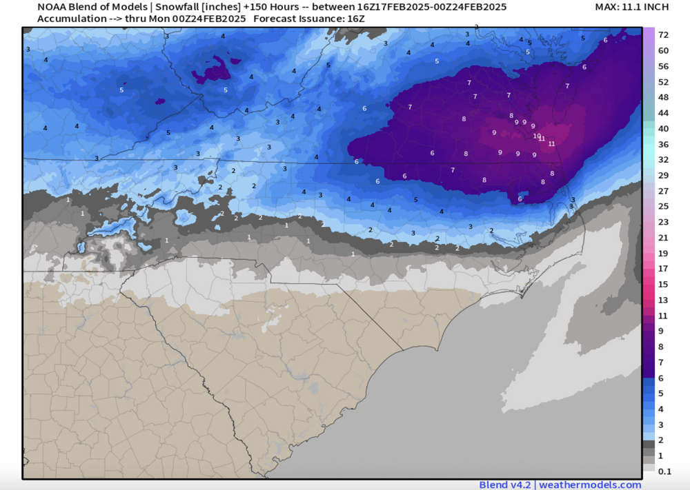
PackGrad05 replied to NorthHillsWx's topic in Southeastern States
It should also be noted that these are all snowfall maps being posted. Outside that snow is still a sleet and fzra corridor. Big impacts regardless. Also, the models are really in great agreement of a maximum over NE NC. The balloon data really helps with the model output. . -
February 19-20 Major Winter Storm Threat
PackGrad05 replied to NorthHillsWx's topic in Southeastern States
-
February 19-20 Major Winter Storm Threat
PackGrad05 replied to NorthHillsWx's topic in Southeastern States
-
February 19-20 Major Winter Storm Threat
PackGrad05 replied to NorthHillsWx's topic in Southeastern States
My general rule with freezing rain is to take model output and divide by 3... Even doing that, that is a still a nasty amount. -
February 19-20 Major Winter Storm Threat
PackGrad05 replied to NorthHillsWx's topic in Southeastern States
Important to look at the jet streaks and favorable right entrance left exit regions . -
February 19-20 Major Winter Storm Threat
PackGrad05 replied to NorthHillsWx's topic in Southeastern States
Agree to disagree. And I never said snow-covered roads... but roads will be a mess. and hazardous. There would likely also be early release or closures of businesses/schools -
February 19-20 Major Winter Storm Threat
PackGrad05 replied to NorthHillsWx's topic in Southeastern States
The GFS shows temperatures in the upper 20s during the afternoon on Wednesday while precip is falling. That would absolutely create hazards on roads. -
February 19-20 Major Winter Storm Threat
PackGrad05 replied to NorthHillsWx's topic in Southeastern States
Roads would be nasty, not just wet.....icy -
February 19-20 Major Winter Storm Threat
PackGrad05 replied to NorthHillsWx's topic in Southeastern States
GFS did trend south, most of Wake would be a sleet/freezing rain mix. As the RAH discussion stated, the GFS would be a moderate nuisance event with impacts during the day Wednesday and lingering impacts Thursday morning from ice on the roads. -
February 19-20 Major Winter Storm Threat
PackGrad05 replied to NorthHillsWx's topic in Southeastern States
I'm on the NWS Raleigh page trying to find previous snowfall maps from past events. I can't find them. Anyone have a link to them? I remember a similar setup to this within 5 years where it kept trending more and more NE and eventually Wake was entirely out of it. -
February 19-20 Major Winter Storm Threat
PackGrad05 replied to NorthHillsWx's topic in Southeastern States
18Z ICON looks almost identical with placement, amounts slightly lower. Still massive gradient across central NC/Wake -
February 19-20 Major Winter Storm Threat
PackGrad05 replied to NorthHillsWx's topic in Southeastern States
As depicted on the GFS, northern wake would be powdery and southern wake would be glazed


