mgerb
-
Posts
273 -
Joined
-
Last visited
Content Type
Profiles
Blogs
Forums
American Weather
Media Demo
Store
Gallery
Everything posted by mgerb
-

July 2020 General Discussions & Observations Thread
mgerb replied to Rtd208's topic in New York City Metro
Absolutely slammed here. Picked up about 2.30" in 45 mins, and 2.60" in an hour. Pretty intense winds (would estimate at least 40-50 mph gusts) that continued for a while. Max rain rate on my Davis of 14.05"/hour, which I think is by far the highest I've ever seen. Definitely an upper-echelon storm among those I've experienced in my 39 years. -
Potential few SVR/FF events parts of NYC forum Wed-Thu 7/22-23/20
mgerb replied to wdrag's topic in New York City Metro
Got around 1.10" from last night's storms, and 1.33" for the day. 7.43" over the past 18 days. But couldn't buy a raindrop for the 30 days prior (0.35"). Summer rainfall is so fickle. -
Potential few SVR/FF events parts of NYC forum Wed-Thu 7/22-23/20
mgerb replied to wdrag's topic in New York City Metro
Not sure. Works for me. Can try this too: https://www.dropbox.com/s/vowbpumt4dt0cjc/2020-07-24 02.45.47.mov?dl=0 -
Potential few SVR/FF events parts of NYC forum Wed-Thu 7/22-23/20
mgerb replied to wdrag's topic in New York City Metro
I took a loop centered on my location, but close enough to you to see much of it. 2020-07-24_02_45_47.mov -
July 2020 General Discussions & Observations Thread
mgerb replied to Rtd208's topic in New York City Metro
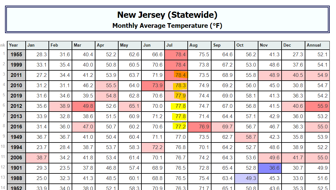
Soon to be 7 of 11. http://climate.rutgers.edu/stateclim_v1/nclimdiv/index.php?stn=NJ00&elem=avgt
-
Potential few SVR/FF events parts of NYC forum Wed-Thu 7/22-23/20
mgerb replied to wdrag's topic in New York City Metro
1.54" from this evening's storms. Sub-severe imby, but a short period of gusty winds of maybe 35 mph. Very satisfying. -
July 2020 General Discussions & Observations Thread
mgerb replied to Rtd208's topic in New York City Metro
Not sure what's up with the Met department page, but we're still bringing in the data through our NJWxNet site. So you should be able to find what you need here! https://www.njweather.org/station/1101 -
How bizarre. *shrug*
-
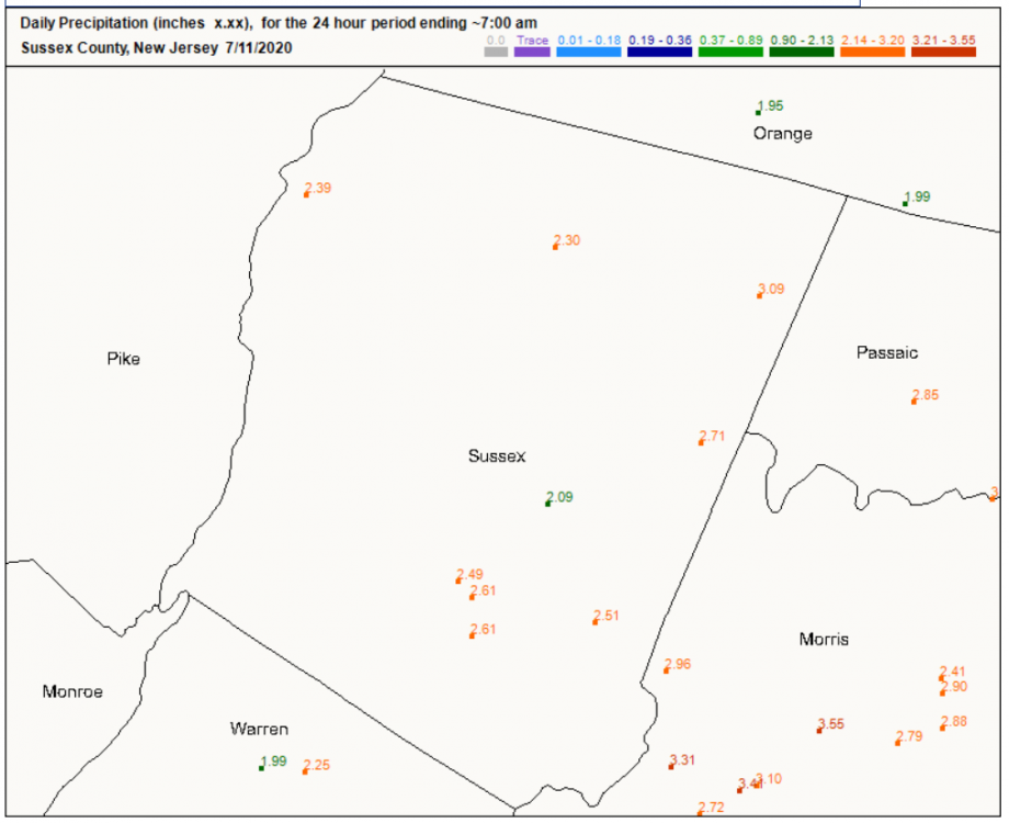
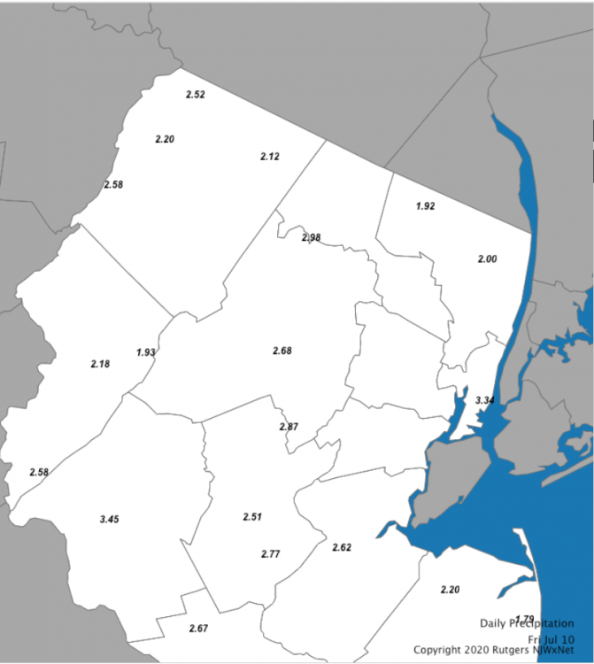
Still at just 1.10" this evening? There's a bunch of gauges in the NJWxNet up your way with 2"+, and I definitely don't doubt what you measured in the plastic 4" gauge (I coordinate the program out of Rutgers; those gauges are top notch). The 2.52" is at High Point (not all the way up, but 1388'), and the 2.12" is our brand new station at the top of the main lift at Mountain Creek (~1394'), which I believe is pretty close to your location? Both are quite similar in elevation to yours, so doesn't seem to be a topographic thing. I'm really surprised by the difference and curious to see what other reports in the area show tomorrow.
-
Hey Walt (Mat from the ONJSC). Saw this yesterday.
-
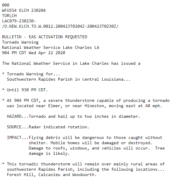
Gotcha. It looks like the storm was continually TOR warned since 9:04, but whether the polygons were inadequate is another issue.
-
For everyone ragging on LCH, I noticed some problems with warnings not displaying in RadarScope this evening. For instance, the post above questions LCH's lack of warning around 9:25 or 9:30 PM, but there was a warning issued back at 9:04 PM. I thing something screwy was happening with the warning polygons (at least in RadarScope).
-
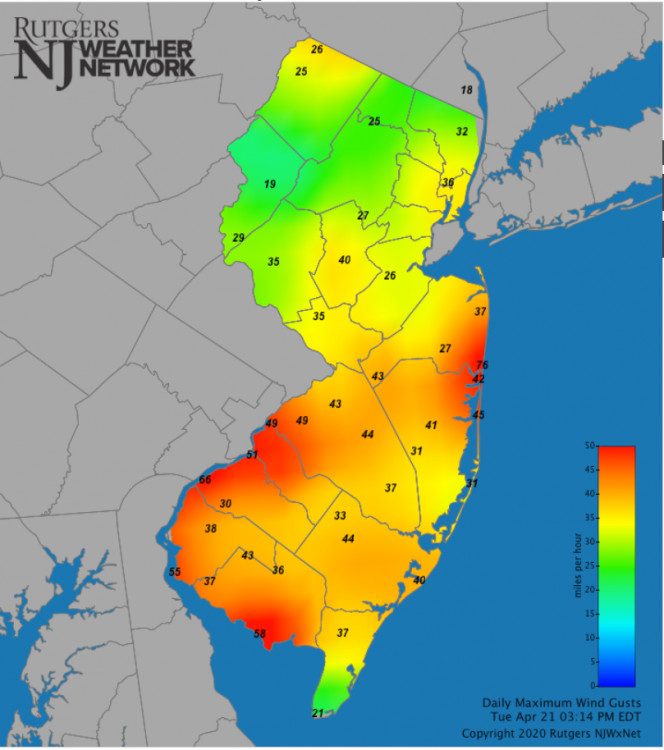
This was a wind-based slight risk. Pretty strong gusts at some NJ sites, including 76 mph at Sea Girt, 66 mph Logan Twp., and 3 other 50+ mph gusts.