
mgerb
-
Posts
273 -
Joined
-
Last visited
Content Type
Profiles
Blogs
Forums
American Weather
Media Demo
Store
Gallery
Everything posted by mgerb
-
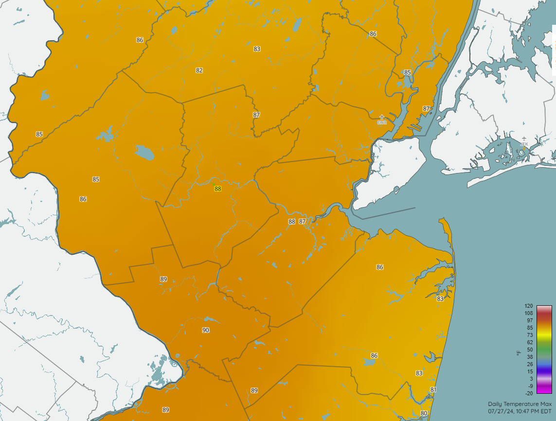
Yes, I have noticed and wondered myself. But it's not a new issue. Ever since it was installed, it seems to be a local warm spot on the hottest of days. And often noticeably warmer than New Brunswick (same sensor type, btw). Aside from any sort of subtle senor bias (which I doubt, but can't preclude with 100% certainty), I think it's probably site related, as the station sits on wide open (and often dry) grasslands, whereas New Brunswick tends to be a more foliated environ. But we'll keep an eye on it. FWIW, it was well in line with other area stations today (granted, not a super hot day).

-
0.06" here. Heavier rain missed to the north and the south.
-
Definitely straight. Microburst no doubt.
-
Mostly missed to my north. 0.01" and some gusty winds with the outflow. Ah well.
-
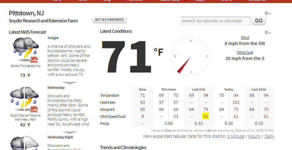
61 mph gust at Pittstown (Hunterdon County).
-
We'll see, but southern flank looks to be strengthening a bit so we may get a good hit here too. Probably will be brief, but very gusty.
-
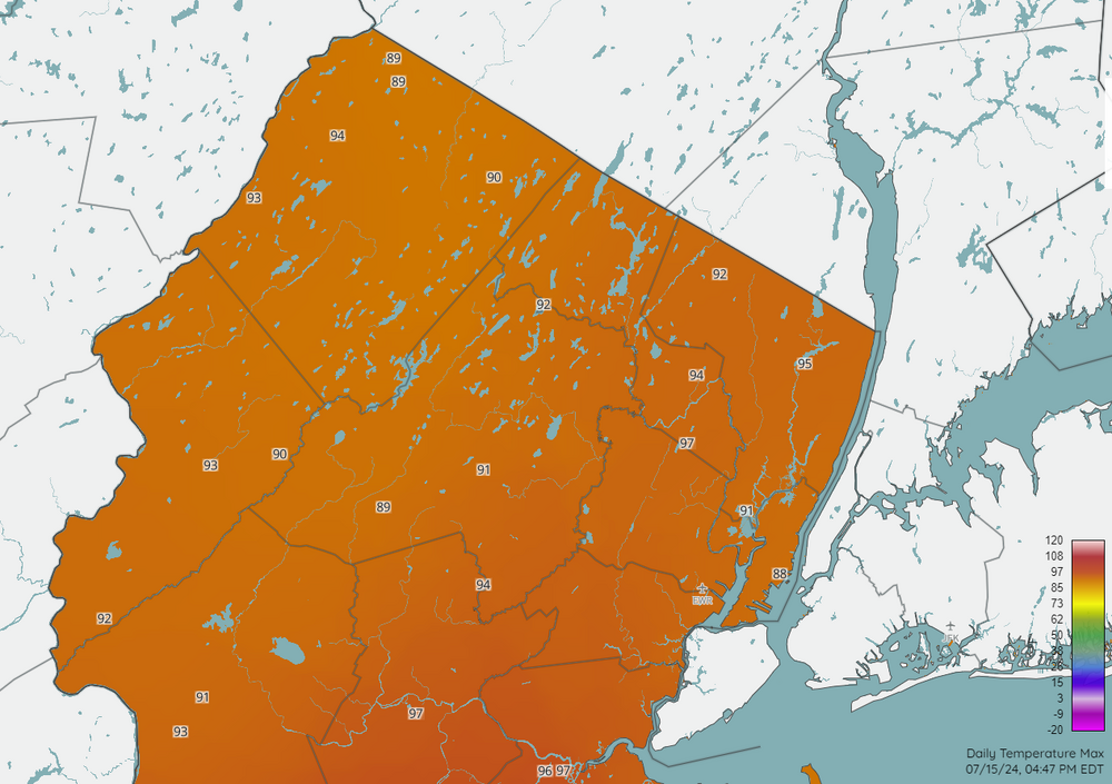
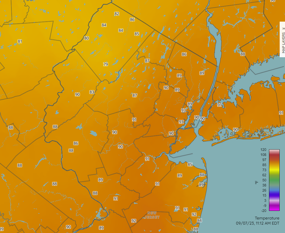
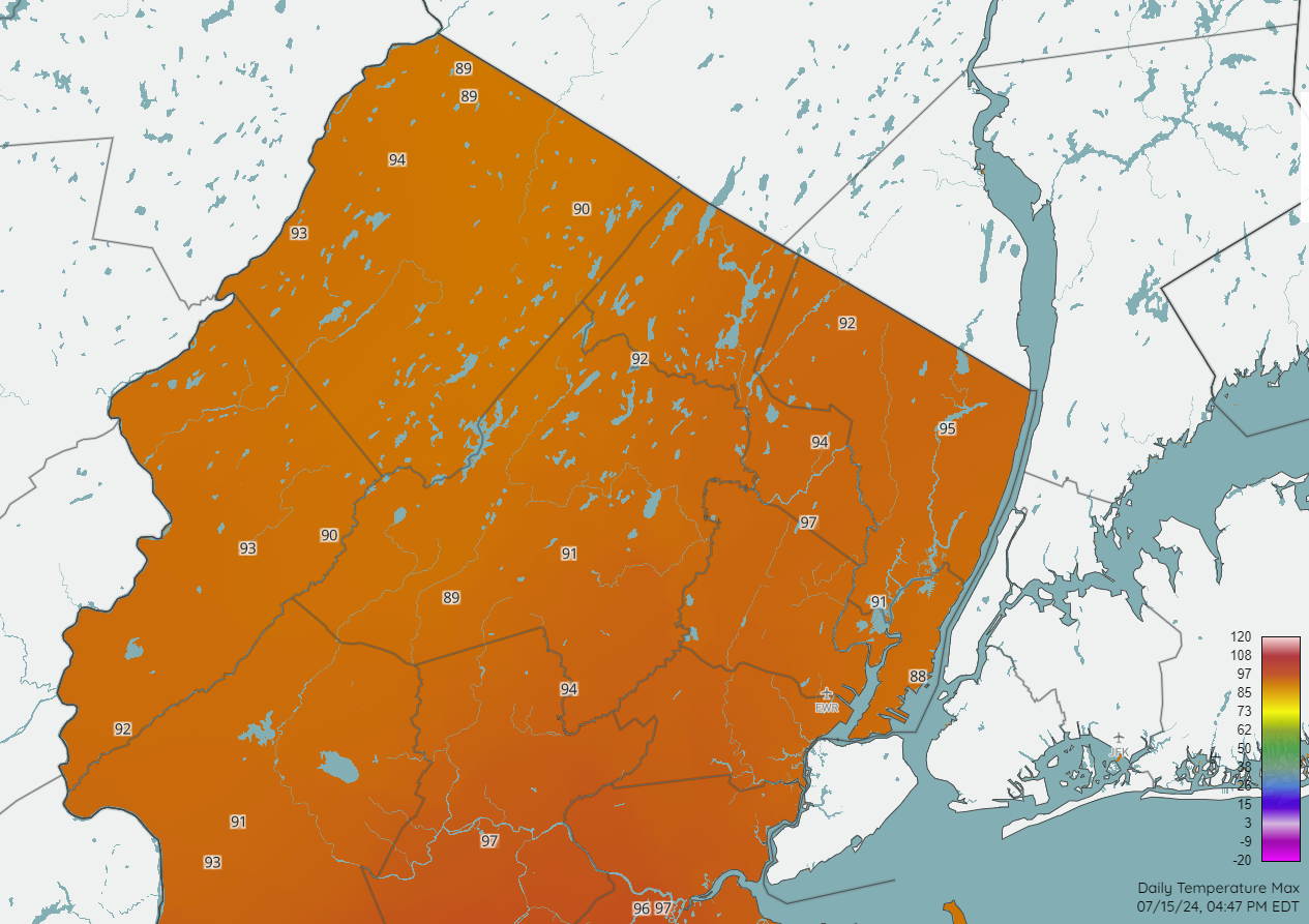
Just posting the same, but zoomed in a bit, as there was at least one site that was not displayed (97 at Little Falls), so did get pretty hot west of the GSP.
-
About the same for me over in Somerset. My Davis shows a maximum rain rate of 13.40"/hr, which may be the highest I've ever seen! Obviously, that magnitude doesn't last very long, but impressive nonetheless.
-
Got about 0.15" just across the river in Somerset. Blew up at the right time to drop some modest heavy rain, but no thunder or any legit torrential rain. Very pulse-y storms and run of the mill.

-
 Dumping pretty good under this band on Somerset. Very fluffy, high ratio. Less than a half inch so far, but let's see this can stick around.
-
Two Mdt to high impact events NYC subforum; wknd Jan 6-7 Incl OBS, and mid week Jan 9-10 (incl OBS). Total water equiv by 00z/11 general 2", possibly 6" includes snow-ice mainly interior. RVR flood potential increases Jan 10 and beyond. Damaging wind.
mgerb replied to wdrag's topic in New York City Metro
1.9" in Somerset upon the changeover to rain (which occurred with no sleet or indication on correlation coefficient). Pleasently surprised as was mainly expecting a dusting or maybe a few tenths.- 3,610 replies
-
- 2
-

-

-
- snow
- heavy rain
- (and 5 more)
-
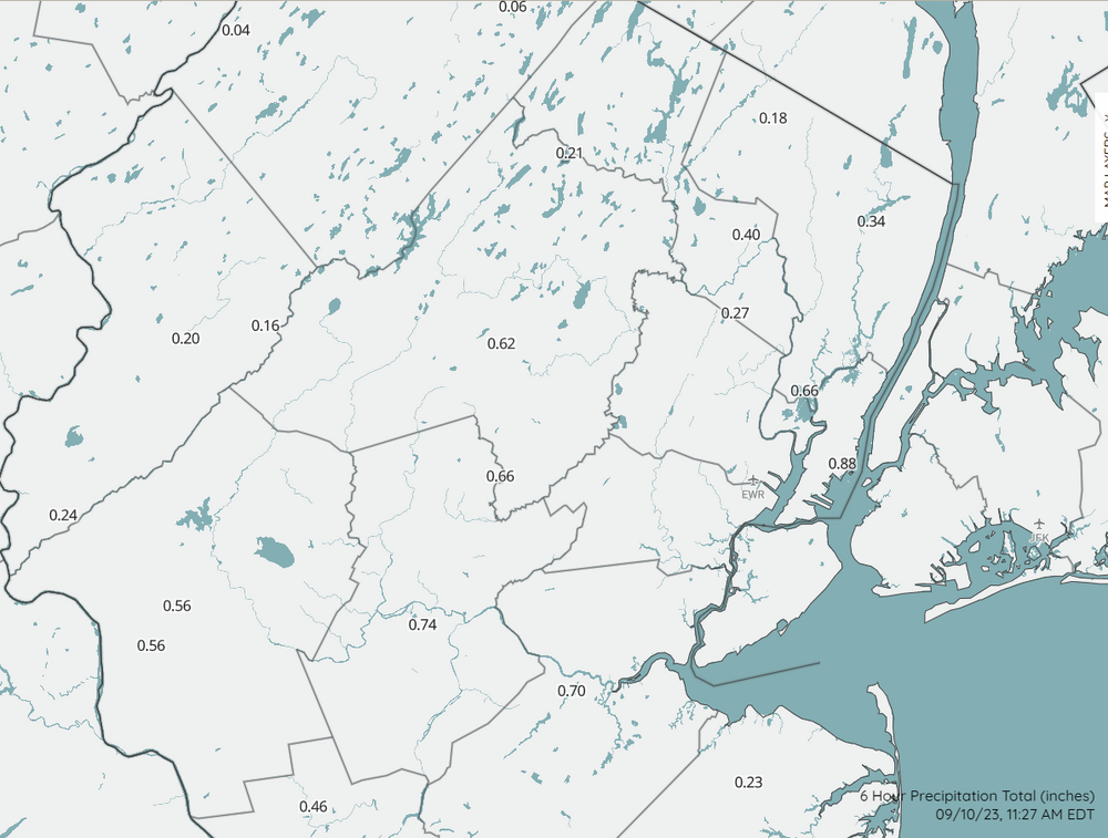
Not airport sites, but there are brand new 1, 3, 6, and 24 precip maps on the new NJWxNet map page here: https://www.njweather.org/maps/ Just select the desired maps in the "map layers" sidebar. Here's 6 hr precip. Over an inch at my home in Somerset from this morning's rain:
-
Hey, I know where that is! That's Landing Lane bridge, right? Just a few miles from me. Was just thinking how awesome it would be to watch today's storm roll in from the southeast way up in one of those buildings. Anyway, strong winds here too (sporadic downed branches), and 5+ minutes of hail, though most was rather small (smaller than dime from what I could tell). Around 0.70" in the bucket. Fun storm.
-
Yup, I'm familiar. I work in the state climate office and sometimes help service the stations. It's mostly a mix of Campbell Scientific EE181 and HC2S3 (more of the former). Then there are 14 stations that use Peet Bros equipment, which is more akin to backyard-type weather stations. With one exception (Harrison) and aside from the Peet Bros stations, we don't pull in any PWS data. We also bring in other professional networks, such as ASOS, AWOS, RAWS, some USGS, and a few others. If you go to any station page (e.g., Little Falls here), near the bottom of the page you can see photos of the site and a list of installed equipment.
-
I have a Davis Vantage Vue that reads high too when in full sun. Non aspirated, and well over 10 years old, so that may be part of the issue, but has read high for as long as I remember. But regarding aspiration, not a single temp/rh sensor (66 in total) operated by the NJWxNet is aspirated, but they don't have that problem. Aspiration is good, but not essential; perhaps has more to do with sensor design or just a biased sensor.
-
Getting pretty bad. This was not underwater 5 mins ago. https://www.mysanibel.com/live-street-cams?utm_campaign=SanCapChamber&utm_medium=referral&utm_source=SanCapChamber Periwinkle and Casa Ybel West. Very strong gusts too.
-
Can see the surge occurring right now.
-
.thumb.gif.98f7f07bdf8d1c2cde2770ae009f0370.gif)
-
Did I miss something? These probs seem insanely high.
-
That guide actually came out in late 2013. Maybe some WFOs disseminated and adopted more strictly than others.
-
You're doing it perfectly right. This is the same that we advocate in CoCoRaHS (I coordinate the NJ program). And yes, also doubling for posting here.
-
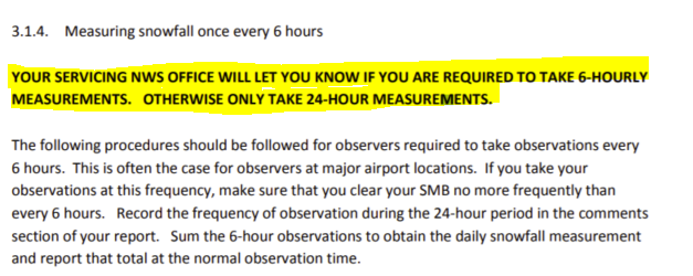
I'd just add that this page is a bit outdated, since it allows for 6-hourly board clearings. Current NWS guidelines have removed that option, unless specifically requested from your local WFO (e.g., airport stations). See pages 6-9 here: https://www.weather.gov/media/coop/Snow_Measurement_Guidelines-2014.pdf
-
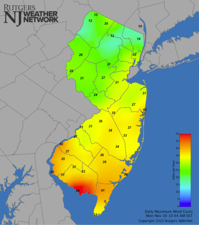
50 mph. All, you can monitor those here (note: problem with maps displaying on Chrome; other browsers should work): https://www.njweather.org/maps/nj-statewide-wind-gusts-daily-max
- 212 replies
-
- 2
-
-
-
- wind damage
- heavy rain
- (and 1 more)
-
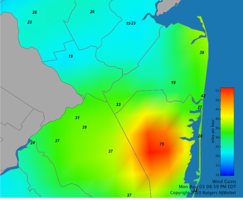
75 mph at Berkeley Twp, which I think is co-located with the Toms River AWOS at Miller Air Park. So they definitely corroborate each other.
- 1,530 replies
-
- 2
-
-
-
- heavy rain
- rip current
- (and 1 more)
-
Can confirm. I was the 2.76" CoCoRaHS in Somerset. 10.31" for the month.
- 1,530 replies
-
- 1
-
-
- heavy rain
- rip current
- (and 1 more)

.gif.53baf181082e20639b68f60741d982ae.gif)
