

ShawnEastTN
-
Posts
1,881 -
Joined
-
Last visited
Content Type
Profiles
Blogs
Forums
American Weather
Media Demo
Store
Gallery
Everything posted by ShawnEastTN
-
Dandridge Dollop 12/24/20 Storm Thread (Winter Wonderland)
ShawnEastTN replied to AMZ8990's topic in Tennessee Valley
Right! Also seen the inverse in recent memory, think in February same year plateau got major icing event a snow event preceded it I think in 2015 or 16 NWS started the day with knoxville forecast of .5" - 1" as the event neared they continually updated amounts all day by that night they issued a graphic of 10"-12" knoxville, Chattanooga got 10" was a huge bust in the positive. Sent from my SM-G965U using Tapatalk- 847 replies
-
- 3
-

-
- cold temperatures
- snow
- (and 8 more)
-
Dandridge Dollop 12/24/20 Storm Thread (Winter Wonderland)
ShawnEastTN replied to AMZ8990's topic in Tennessee Valley
I've always been partial to the RGEM it seemed to be in years past better at sniffing out trailing pieces of energy. I think it did a better job at sniffing out the trailing energy that made the event at the start of the month over perform for most folks. Sent from my SM-G965U using Tapatalk- 847 replies
-
- 3
-
-
- cold temperatures
- snow
- (and 8 more)
-
Oak Moon Upslope/ Upper Low Storm Obs
ShawnEastTN replied to Holston_River_Rambler's topic in Tennessee Valley
Lol they cut accumulations from lower elevations all together in their afternoon update. Sent from my SM-G965U using Tapatalk- 300 replies
-
- 1
-
-
- upslope snow
- upper level disturbance
- (and 3 more)
-
Oak Moon Upslope/ Upper Low Storm Obs
ShawnEastTN replied to Holston_River_Rambler's topic in Tennessee Valley
Peachtree City just expanded their Winter Weather Advisory to include areas outside the mountains of North Georgia all the way down to far northern Atlanta suburbs. Think they might have been caught off guard to the snow showers making that far south. Sent from my SM-G965U using Tapatalk -
Oak Moon Upslope/ Upper Low Storm Obs
ShawnEastTN replied to Holston_River_Rambler's topic in Tennessee Valley
Yeah I see that all the time with snow where I live. Sometimes nothing on the radar for me from MRX, Hytop, or Nashville but snow falling.- 300 replies
-
- 2
-
-
- upslope snow
- upper level disturbance
- (and 3 more)
-
Oak Moon Upslope/ Upper Low Storm Obs
ShawnEastTN replied to Holston_River_Rambler's topic in Tennessee Valley
Really impressed with the amount of upstream moisture still to work through. Still good moisture all the way up in to Illinois and Indiana rotating this direction.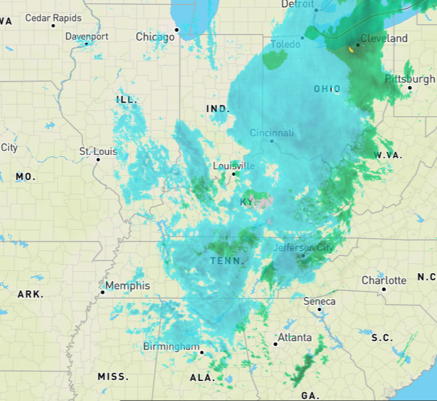
- 300 replies
-
- 4
-
-
- upslope snow
- upper level disturbance
- (and 3 more)
-
Oak Moon Upslope/ Upper Low Storm Obs
ShawnEastTN replied to Holston_River_Rambler's topic in Tennessee Valley
Agree, makes sense considering the good valley flakage here. Normally in NW flow I get very fine flakes that are pretty dried out if I get anything at all. Today I've gotten off and on fluffy flakes that just didn't feel NW flow like. Sent from my SM-G965U using Tapatalk- 300 replies
-
- 2
-
-
- upslope snow
- upper level disturbance
- (and 3 more)
-
Oak Moon Upslope/ Upper Low Storm Obs
ShawnEastTN replied to Holston_River_Rambler's topic in Tennessee Valley
First sort of moderate snow, honestly never expected this in the valley. Sent from my SM-G965U using Tapatalk- 300 replies
-
- 3
-
-
- upslope snow
- upper level disturbance
- (and 3 more)
-
Oak Moon Upslope/ Upper Low Storm Obs
ShawnEastTN replied to Holston_River_Rambler's topic in Tennessee Valley
That's what I'm hoping for too. That's sort of how it started for me then over to flakes that vary in intensity off an on for the last 30 minutes or so. I'm hoping the RGEM is correct in depicting another lobe of energy making its way through after dark, think that will be our best shot in the low elevations at a little dusting since it'll be colder and squeeze out every drop of moisture. Sent from my SM-G965U using Tapatalk- 300 replies
-
- 1
-
-
- upslope snow
- upper level disturbance
- (and 3 more)
-
Oak Moon Upslope/ Upper Low Storm Obs
ShawnEastTN replied to Holston_River_Rambler's topic in Tennessee Valley
Finally getting just flakes now at a nice clip. Sent from my SM-G965U using Tapatalk- 300 replies
-
- 3
-
-
- upslope snow
- upper level disturbance
- (and 3 more)
-
Oak Moon Upslope/ Upper Low Storm Obs
ShawnEastTN replied to Holston_River_Rambler's topic in Tennessee Valley
Can confirm this radar return is mix rain snow and reaching the ground. Still sitting at 38/39 degrees. Sent from my SM-G965U using Tapatalk -
Oak Moon Upslope/ Upper Low Storm Obs
ShawnEastTN replied to Holston_River_Rambler's topic in Tennessee Valley
Had rain graupel/melted snow flake slop a few minutes ago on the Roane/Meigs county line area. Sent from my SM-G965U using Tapatalk- 300 replies
-
- 1
-
-
- upslope snow
- upper level disturbance
- (and 3 more)
-
Oak Moon Upslope/ Upper Low Storm Obs
ShawnEastTN replied to Holston_River_Rambler's topic in Tennessee Valley
0z RGEM seems to have slightly ticked up snow totals across the whole of the area. Running through frames to my untrained eye it seems to pick up on a piece of energy rotating down out of Southern Indiana around 14z monday into Kentucky then Tennessee through the evening and night, even appearing to over come downsloping in the great valley. Sent from my SM-G965U using Tapatalk- 300 replies
-
- 2
-
-
- upslope snow
- upper level disturbance
- (and 3 more)
-
December 2020 Medium/Long Term Pattern Discussion.
ShawnEastTN replied to John1122's topic in Tennessee Valley
Absolutely! At least it used to always be that way right about this timeframe we lose it and hope is dashed then triumphantly comes back about 24 hours later. Hopefully the case here but it is 2020 so probably going to evolve to massive severe event and no freezing precip except damaging hail. Sent from my SM-G965U using Tapatalk -
Wild Speculation for Winter 20 -21
ShawnEastTN replied to Holston_River_Rambler's topic in Tennessee Valley
I smell a AN November coming on... Maybe that'll help with timing of colder blasts at climatological best opportunities of winter. Then again it seems over the last several years the correlations that seemed reliable in years past aren't as reliable today. Sent from my SM-G965U using Tapatalk -
NAM vs the Euro cage match storm, Feb 20 - 21
ShawnEastTN replied to Holston_River_Rambler's topic in Tennessee Valley
Same here maintaining a good N NNE wind at 5 to 10 mph. Looks like the dewpoint battle line is sinking southward also a bit.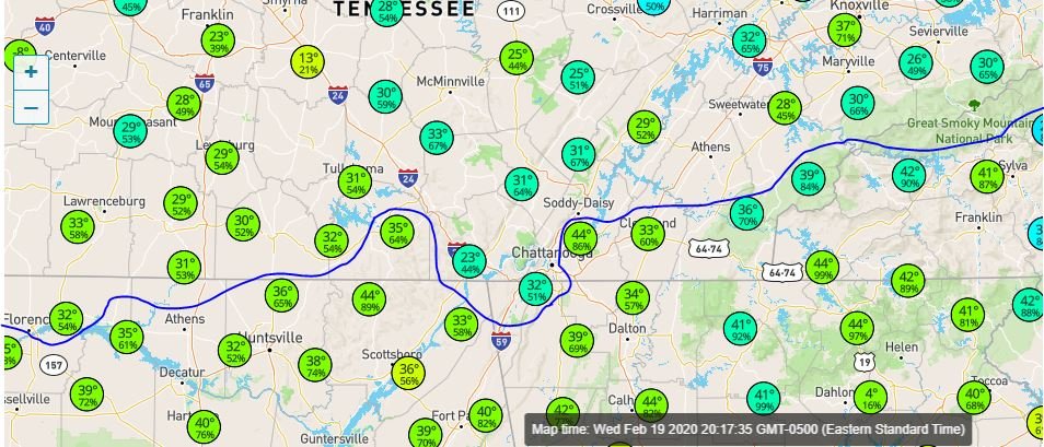
-
NAM vs the Euro cage match storm, Feb 20 - 21
ShawnEastTN replied to Holston_River_Rambler's topic in Tennessee Valley
My dewpoint definitely falling. Was 29 at at 530 now down to 27. Temp 46. Sent from my SM-G965U using Tapatalk -
NAM vs the Euro cage match storm, Feb 20 - 21
ShawnEastTN replied to Holston_River_Rambler's topic in Tennessee Valley
I think this is going to be interesting... Dewpoints around the valley are intriguing. My dewpoint currently is 29, most locations from a line from Dayton to Athens and north are around or below freezing except nearest to the Eastern mountains and far southern valley where dewPoints are in the mid to upper 30's. Sent from my SM-G965U using Tapatalk -
NAM vs the Euro cage match storm, Feb 20 - 21
ShawnEastTN replied to Holston_River_Rambler's topic in Tennessee Valley
Morristown seems to be running a little later than normal on their Afternoon Disco today, bet they are in serious debate at the moment. Sent from my SM-G965U using Tapatalk -
NAM vs the Euro cage match storm, Feb 20 - 21
ShawnEastTN replied to Holston_River_Rambler's topic in Tennessee Valley
Winter Storm Warnings hoisted for the mountains. Sent from my SM-G965U using Tapatalk -
February/March 2020 Winter's Last Chance Thread
ShawnEastTN replied to John1122's topic in Tennessee Valley
I definitely don't expect any watches as in Winter Storm Watches, I would not be surprised to see WWA for far southern counties after 0Z, I know MRX hugs Euro and it's thermals are not great but with neighboring CWA pressure for continuity and the model trends I could see it, however it's far more likely tomorrow after 12z. Sent from my SM-G965U using Tapatalk -
February/March 2020 Winter's Last Chance Thread
ShawnEastTN replied to John1122's topic in Tennessee Valley
I'd say it's possible southern valley tonight after 0z, SPS at minimum, but more likely by 12Z tomorrow if modeling by NAM holds and globals trend as they have in small steps today. Sent from my SM-G965U using Tapatalk -
February/March 2020 Winter's Last Chance Thread
ShawnEastTN replied to John1122's topic in Tennessee Valley
Morristown's first guess. Sent from my SM-G965U using Tapatalk -
February/March 2020 Winter's Last Chance Thread
ShawnEastTN replied to John1122's topic in Tennessee Valley
I think I remember a handful of those over the years, those are the ones that I remember Morristown having to continually up their forecast snow totals for during the actual events. Sent from my SM-G965U using Tapatalk -
February/March 2020 Winter's Last Chance Thread
ShawnEastTN replied to John1122's topic in Tennessee Valley
Would be awesome if we can get that NNE wind down the valley during this event, those have been life savers for these scenarios in the past. Sent from my SM-G965U using Tapatalk

