Huffwx
-
Posts
2,880 -
Joined
-
Last visited
Content Type
Profiles
Blogs
Forums
American Weather
Media Demo
Store
Gallery
Everything posted by Huffwx
-
Jan 5-6 event = 2.5 then buckets of ZR Jan 10-11 event = 2.8 Feb 11-12 event = 5 total with 3.8 snow and 1.2 sleet before bucks of ZR Feb 19-20 event. 2.0 round 1, 1.5 with ULL passage for 3.5 total. 13.8 on season Near climo which is 15-16 ish now and fading fast.
-
We pulled a 2 yesterday and 1.5 this AM up here in Forest. Fine high ratio powder this AM that melted at the first crack of sun. 3.5 total not too shabby.
-
Another Lynchburger.. I'm in Forest. 2.5 then 2.8. Total- 5.3
-
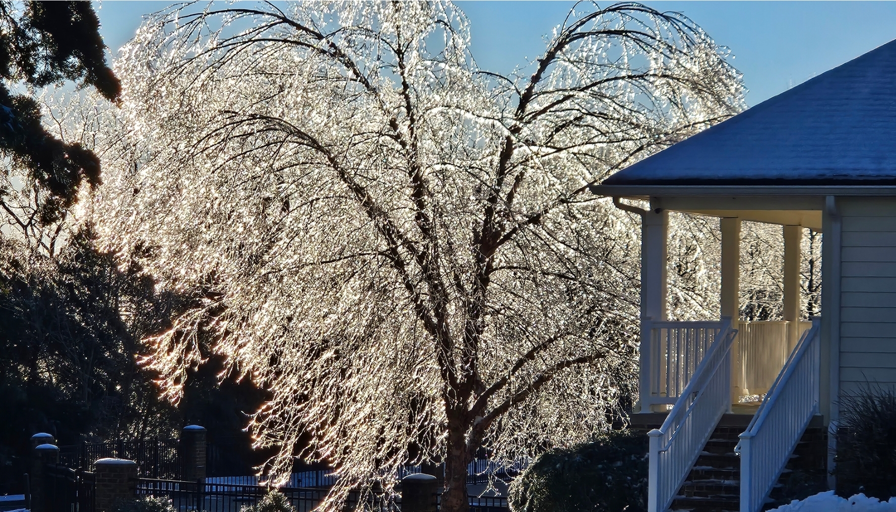
About. 2.5 snow and sleet in Forest, VA then tons of ZR.. had a departing snow shower late afternoon. Would have preferred snow but the trees look phenomenal. Pics not catching the full glimmer from the sun..

-
29 and light snow down here in Forest, VA
-

January: Medium/ Long Range: May the Force be with Us....
Huffwx replied to Weather Will's topic in Mid Atlantic
Hey Howard, I'm doing well- I work FULLTIME telehealth now chatting with my clients. Pretty fun-- I still think about your legendary parking job at G&M's crabcakes-haha. How's life treating you? -
January: Medium/ Long Range: May the Force be with Us....
Huffwx replied to Weather Will's topic in Mid Atlantic
I'm up in Forest but also have a house in Rocky Mount. Welcome to the hood. You picked the non snowy side of the lake. Weve been looking to consolidate near the and I've already states Goodview was my preferred location:) Marginal events lake warmth will hurt.. -
Hey now, Howard. It's been a minute.
-
This. That 500 low goes negative a low forms over South Carolina
-
Most won't remember but when the Jan 2000 storm passed over KC upper air vort (like this one will be close) they had a snow event that caused the icy roads that lead to the car wreck that ending up killing Derrick Thomas, albeit 2 weeks later. Morbid, i get it but I always connect the two.
-
Not that the reverse psychology works, but it seems the Euro and UK seasonal outlooks were promising in the 2 of past 3 winters. I guess last winter had some great features (-nao) with no blocking, so who knows. That be a super warm winter though.. like you said.
-
NYC Central Park has a 40 inch winter and someone complains about it-- Wow.
-
That flat ridge in the GOM isn't helping anyone.
-
Pretty warm out in front-- despite the NAO and lower heights near 50/50. IT's a timing issue where cold air is coming at the same time as the storm. Could end up 300 miles north or south depending on timing.
-
I live just outside Lynchburg. Was 40 the day before and the day after. Snowed all day with temps in the mid 20's. We did have perfect timing with a HP sliding through but the air was more dry than cold. Take out the precip and we would have hit 40 that Sunday as well.
-
Ji showed a graph where the NAO wasn't negative. I said a few times heights were higher Azorors were high as well and that is how they measure ( or use to) A lot of gray on on the calculations but agree base is warmer and PAC isn't helping. In early 02, we had blocking and it got colder as heights lowered. Had a suppressed storm Richmond to RDU.. maybe 12 at RDU again.
-
Heights were high near Azores as well..
-
We have high heights over Greenland but the block extends to near the Azores.
-
GOOD CHANCE OF 1ST LIGHT SNOW EVENT VA / nw NC/ MD DEL MONDAY DEC 7
Huffwx replied to DTWXRISK's topic in Mid Atlantic
Had about .3 at my place in Forest. My office is right behind WSET TV- the official measuring station for Lynchburg. They were shut out last year for the first time ever (We had .3 in Forest last year too) Not sure what fell here at my office counts as more than a trace. -
Mid-Atlantic winter 2020-21 snowfall contest
Huffwx replied to PrinceFrederickWx's topic in Mid Atlantic
BWI: 14 DCA:9 IAD:17 RIC:5 Tiebreaker ( LYH): 12.5 -
Mid January/Mid February Medium/Long Range Discussion
Huffwx replied to WinterWxLuvr's topic in Mid Atlantic
Yeah, only one day out of school with 15 inches where I was. If this vort passes to anyones south, they would get some crazy rates for a while. -
Mid January/Mid February Medium/Long Range Discussion
Huffwx replied to WinterWxLuvr's topic in Mid Atlantic
That was Feb 87. Temps hit upper 40s where i was but were at 37 when it started and hoovered around 32 all storm. Was a triple phaser actually. -
About 1.25 just west of Lynchburg. Crappy ratio..7 to 1 maybe but roads are coveres. Sleet in Roanoke off and on. Hopefully we hold out a few hours.
-
Best Mid-Atlantic winter storm of the last 40 years
Huffwx replied to PrinceFrederickWx's topic in Mid Atlantic
That's high considering the RIC and SW posters. Jan 87 was much better.. -
Best Mid-Atlantic winter storm of the last 40 years
Huffwx replied to PrinceFrederickWx's topic in Mid Atlantic
I raked leaves that afternoon. I remember calling the weatherline that RICH HITCHENS worked Sunday am after a sleepover over and was shocked there was a WsWatch Sunday AM.. Saturday PM had a chance of rain or snow Sunday night. Gotcha. I guess the 00 storm to me was such a drastic shift from no storm out to see to BIG event in 6 hours. Now, Feb 22 87 was actually a triple phaser if I'm not misaken and it bottomed out 965 east of ACY?? So, I guess that was a big miss in that context but more lead time where I was in a lesser model era resonates with me.