ROOSTA
-
Posts
3,009 -
Joined
-
Last visited
Content Type
Profiles
Blogs
Forums
American Weather
Media Demo
Store
Gallery
Everything posted by ROOSTA
-

December 2024 - Best look to an early December pattern in many a year!
ROOSTA replied to FXWX's topic in New England
The never-ending search for the next big one has commenced. A sniff here and sniff there. It stinks so far. Somebody with a good sense of smell needs to chime in! -
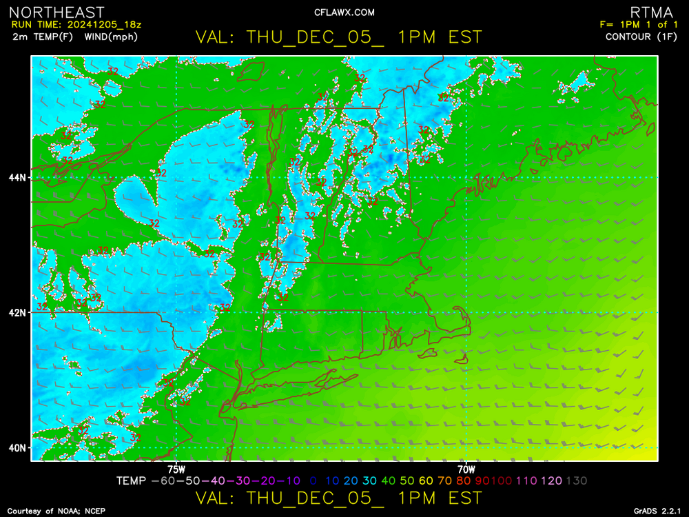
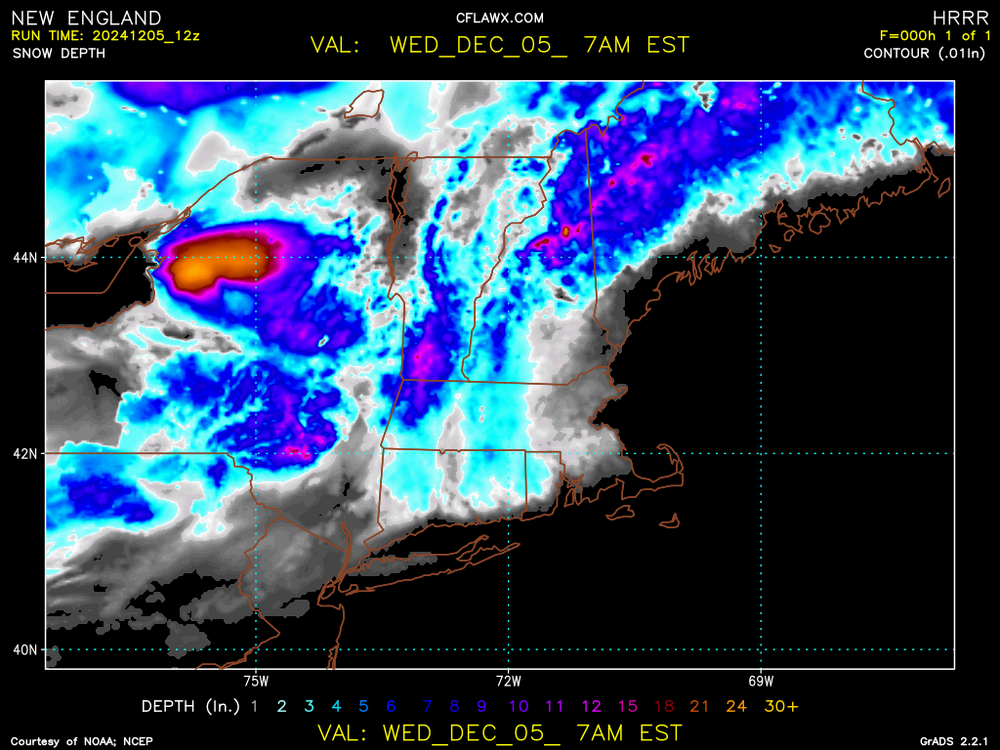
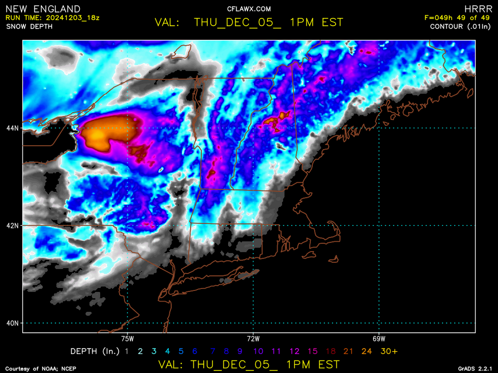
For early December having this event hopefully portends good things to follow. Latest RTMA for SNE.
-
You all are going to know when the front approaches and passes. Mucho instability involved. Wish I was there for it. Some areas will experience 10 minutes or so of whiteout conditions. After passing the winds... Oh, boy fun times.
-
An overachiever. Last minute flags come true for once. I'm happy for all. Windex event sweeping across NY. Hopefully a sign henceforth...
-
I'm thinking maps should go into a separate thread. No two maps are the same. As much as I like posting them anything less than 6" IS Bull Crap. I'll wait till it's worthy of note as in over a foot. ***That's what she said***
-
This looks about right.
-
John, aka Tip I want to state something in that most posters in here don't have a clue, re: Scientific explanations nor take the time to learn. It's always going to be inexact; no forecast or reasoning will be correct. I'm grateful for your logical explanations teaching this old dog on every post. Numerous posters like yourself are appreciated (we know which posters to believe and which to totally ignore) To many good posters have left the forum please don't even think about it.
-
I was hoping to see a modeled Blizzard. D10 or closer. Not so much for New England but anywhere in the CONUS. Clippers just don't seem to cut it. I've always wanted to see some flurries IMBY, maybe this year...hoping anyway!
-
Seems as though elevation will be a major player as in most early/late season events. Soundings are critical if one wants to know what type and how much in YBY.
-
Just so you know, any snow is good snow. First flakes are magical. Now hoping trillions fall upon y'all.
-
December 2024 - Best look to an early December pattern in many a year!
ROOSTA replied to FXWX's topic in New England
For the month? YES Numerous (4 or more) threats will be tracked. Oh, grasshopper just look at the pattern through the trees. -
December 2024 - Best look to an early December pattern in many a year!
ROOSTA replied to FXWX's topic in New England
Potential threats are numerous. Pattern looks good for early snows. Of course, the usual timing, phasing. moisture, air mass and track come into play. Also, any other variable one can think of. -
Blowvember - and not named for wind potential
ROOSTA replied to Go Kart Mozart's topic in New England
A post from my FB presence When trying to "sniff" out storms it's very difficult getting the timing correct. First thing to consider is the larger picture. Hemispheric and Continental patterns must align in general to create conditions that are conducive for just the formation of a storm. I might have jump on this threat to early. Models are not in agreement for a widespread snowstorm. That is a red flag of caution, usually resulting in no storm. The threat is still present but down to (1) Pattern recognition is crucial. This threat seems to be slipping away. Still must watch very closely if things change! Even when conditions are perfect, everything is in agreement the devil in the details on a meso-scale must be considered bringing all the variables into play. Extremely difficult to forecast! -
Blowvember - and not named for wind potential
ROOSTA replied to Go Kart Mozart's topic in New England
Looking very winter-esque. Potential for a few events over the next 2 weeks. Something to track and scrutinize is better than nothing. One at a time, awaiting the thread... AND SO, IT BEGINS -
Without question. Time to get the sharpener out for the upcoming Winter Season threats. Oh, FYI the flooding from Helene and Milton are still ongoing. Move and stop building in low-level areas. People will never learn but rather blame the government officials.
-
It ain't ova till it's ova. Seems that big slow-moving canes have been developing the last few seasons late. This year is no exception. Signal is strong, repeating SIGNAL IS STRONG. Not looking forward to this one in any form it takes. Flooding is still on-going and my tree isn't chopped yet. Taking a 180, first snow in Boston DEC 18th.
-
People are still without power. It's the flooding that has affected most of the area and will continue for weeks to come. Trees are downed everywhere. Takeaway is the most destructive aspect of the storm, FLOODING. I DON'T THINK THE TROPICS ARE OVER FOR FLORIDA! I consider (one tree in front) myself to be lucky. I'll never flood, and the house is sturdy enough build well with a hurricane standard roof. No chainsaw to be had anywhere within 50 miles.
-
Surprise, surprise my power is out. Only one big pine fell, lucky. Only a foot of rain, highest gust 85mph.
-
Meant to post earlier https://www.facebook.com/share/p/B1WTggiDn4ppvrmC/ A variety of cams
-
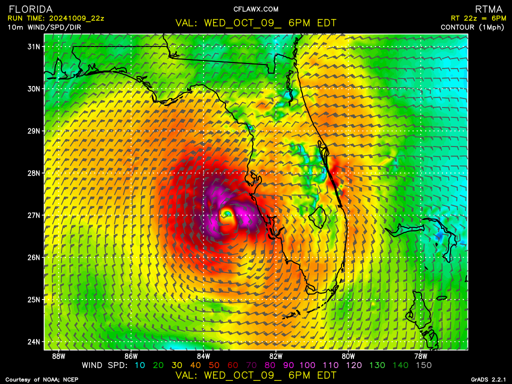
The Inner Core is intact

-
Blitzortung.org - Live Lightning Map Already starting to get some rumbling. This is not good.
-
Discrete cells with definite hooks propagating outward in the first true outer spiral band - RFQ Does anyone know how fast an EWRC has taken place? My expected gusts have dropped for N. Lake County. I just want the power to stay for one good meal Dinner tonight. LF Tampa Bay.
-
Moving slightly N of NE at least by my estimate. TB radar using GR3v2 range rings with marker. Official forecasted track N of previous advisory. GFS (hot stuff) has been steadfast on track. Social Media is bonkers everyone has an opinion, not worth posting anymore.
-
Almost in radar range. Discrete cells - waterspouts galore KBYX. Not a good sign for RFQ EF spin-ups tomorrow.
-
Yes, gaining more LAT than LON presently and not a wobble. My call straight into TB. Call it THE TB12 payback for Pats fans. LOL j/k Serious stuff right there. ****** PSU website has 1 minute refresh with better resolution for SAT