ROOSTA
-
Posts
3,009 -
Joined
-
Last visited
Content Type
Profiles
Blogs
Forums
American Weather
Media Demo
Store
Gallery
Everything posted by ROOSTA
-
GFS 18z: Looks tropical, looks like it has an eye. The worst-case scenario for East Central Florida. Thankfully a week out.
-
I'll still be basking in the 80's. Always a thrill to see at least the threat. Transitional Seasons are the best. I don't think the tropics are done.
-
DO NOT LOOK AT THE L/R OPERATIONAL GFS. And so it begins, a threat of snow over a wide area in SNE. Should garner a topic thread if subsequent runs continue to show.
-
I got lucky. Untouched only 18hrs without power.
-
The exact opposite. Tampa Bay emptied out.
-
Not confirmed but reported on local TV station, gusts near LF in the 170 range. Water rescues everywhere. Moving into feeder band right now. This is knocking power out... see you's all on the otherside. New Smyrna Beach 74G in the last hour.
-
Reverse Surge, Tampa Bay emptied out. What? First strong feeder band knocking. Highest recorded gust 135mph. 4th strongest hurricane in history to hit the US.
-
I'm already gusting into the 30 range. I think my IP address has been blocked from desktop? 2 feet of rain inbound. As ready as I'm ever going to be.
-
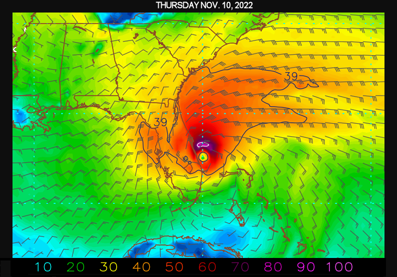
No propane, no gasoline, water flying off the shelves. Highways jammed and then you have the yahoo's who are oblivious and stay even along the coast, D'OH I fear the power will be gone for days. Irma was 6 days prompting a generator purchase. This is going to be stronger, longer. I'm glad the latest are going S. A few runs back tracking right overhead. AFD has 100+ gusts, isolated 24"+ in wordage with a lot of extremes to boot. Venice to Daytona Beach. In at 140 out at 40
-
People get more upset about "their" The Second Amendment Rights then they do about "their" First. I digress. Ian's general movement since entering the Gulf is approx. (per radar) at 16.3 degrees which if extrapolated places LF just S of Venice.
-
The width is expanding. Whom ever gets into the eyewall is in for a wild ride, damaging too. So wide the State is becoming dwarfed. Not often do you see H force winds gate to gate across.
-
Having some fun with the software.

-
I wish I had a faster connection to the Internet. 130mb to complete download. GOES-East ABI Mesoscale 1 - 0.64 um - Band 2 (nasa.gov) One-minute updates, detailed structure of the eye. Can see the stadium effect and the hot towers. Behold the Power, WOW
-
EYE diameter at LF in Cuba @15 miles across. Interaction with land should turn this beast to the right ever so slightly. Implications on LF location. Wondering if Ian can obtain CAT5 strength? Oh, hell I'm all in for wanting to experience an eye passage. I'm going to have to get more supplies. Getting anxious bordering on nervous.
-
Eye is present on KBYX radar. Sleeping is over-rated.
-
OVER/UNDER 20" of Total Precipitation? ________________ Roo- OVER
-
Several Thunderstorms moving across the peninsula general motion from the SE moving toward the NW. An Outer-Outer band, great, a nice PRE event. Stakes are extremely high as is my anxiety starting to rise. Many people are going to be shockingly surprised if they don't heed evacuations. A disaster waiting to happen.
-
I'm well inland. Presently, latest model forecasts "if correct" re: Ian's track will be 75-100 miles to the W. Sustained TS winds will begin WED night and not abate till FRI morning. THAT'S A GOOD POUNDING.
-
Finally going NUCLEAR. BOMBS AWAY! LOL
-
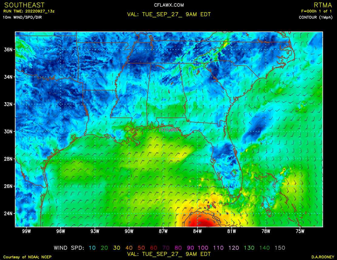
One thing I've noticed on the model graphics in particular 10m wind none of them get inland speeds correct. Like the wind stops at the coast?
-
Come on down WU KFLALTOO10
-
Wait. With all the forecasted precipitation, won't take much wind to bring down trees and cut transmission lines. Widespread outages for days. I went 6 days without on just a brush-by a few years ago.
-
Hey Steve, Altoona LAT 28.97 LON 81.63 ASL 108FT. Wide-open area so there will not be flying projectiles. I'm going to have to stock-up on water and non-perishables. The stores should open back-up quickly. It's the electric I'm really worried about. Other concerns to lesser degrees. Big Old Southern Oaks surround the house, I mean huge they must be over 200yrs. old. No window protection. Need a battery back-up for at least 1 computer to run observations and keep the camera running.
-
I'm going to need a boat. From the onset of this tropical system as a threat since what a week, 10 days ago I've really tried to avoid the run-to-run model craze. It's crunch time, it's coming, I'm hooked. It was the GFS that in one run had 40-50" of TOTAL-P, that run also featured a direct hit. Whew! A weakening system with landfall near the Big Bend on the present trajectory is still a severe hit for my location. Ian appears to be getting its act together and because of that the trend to track into the Pan Handle are diminishing. Time to stock-up.
-
Since moving to FL. I've experienced several Tropical systems luckily; I'm located well inland and not taken a direct (severe) hit per se. 89mph. has been the highest recorded wind speed. I moved 2 yrs. ago down-the-street. Previous dwelling was a hand-build log structure, could and will withstand Category 4 for many years to come. I outfitted with a generator, new roof, a pool the buyer purchased a special home. Moved to an expansive property (10 acres) surrounded by cut pasture with few trees. House is brick circa '78, 2400sq ft. All because I chased some tail, that Beast-of-burden is long gone thankfully...anywho... my health has prevented me from enjoying all the new place has to offer. The GFS has been consistent trending W for several runs. The EURO has been steadfast S and E with slight adjustments to the track W. Given the timeframe and the storm has finally formed the BADBOYS seem to be coming to a compromise. A W coast scrapper? Still time to prepare, still time for the models to (models to do what models do) slight E track trend on the GFS, slight W track on the EURO. ROOSTA ON WATCH.