ROOSTA
-
Posts
3,010 -
Joined
-
Last visited
Content Type
Profiles
Blogs
Forums
American Weather
Media Demo
Store
Gallery
Everything posted by ROOSTA
-
 BOMBS AWAY Need this to be inside D5. As is I might get to a flurry. "The road is long with many a winding turn." Looking mighty fine!
 -
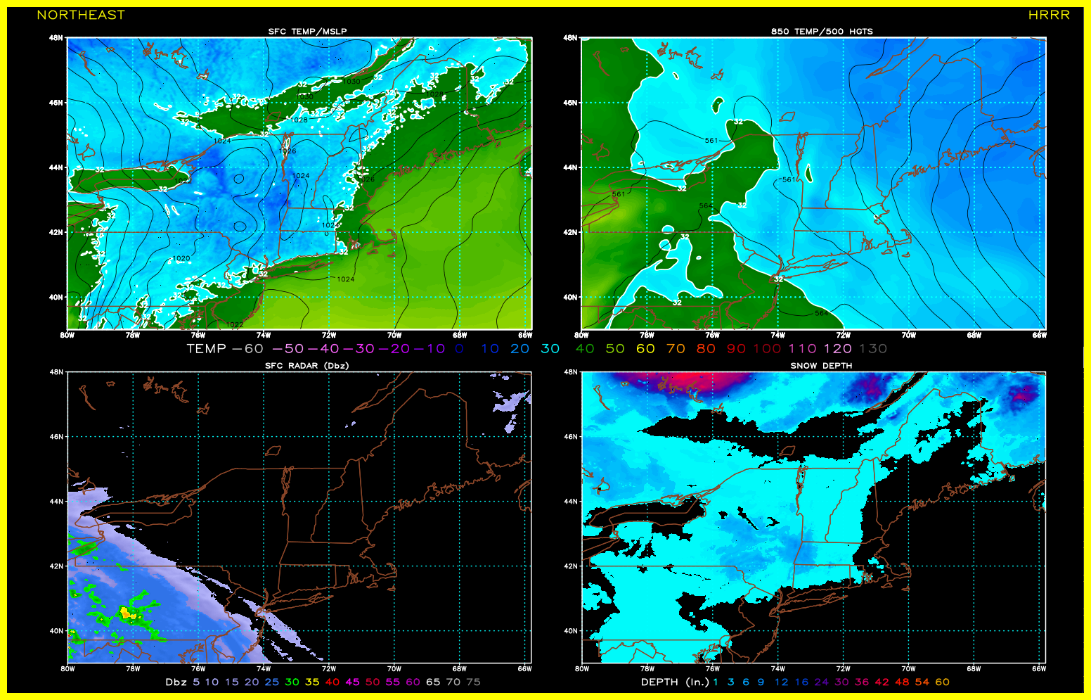
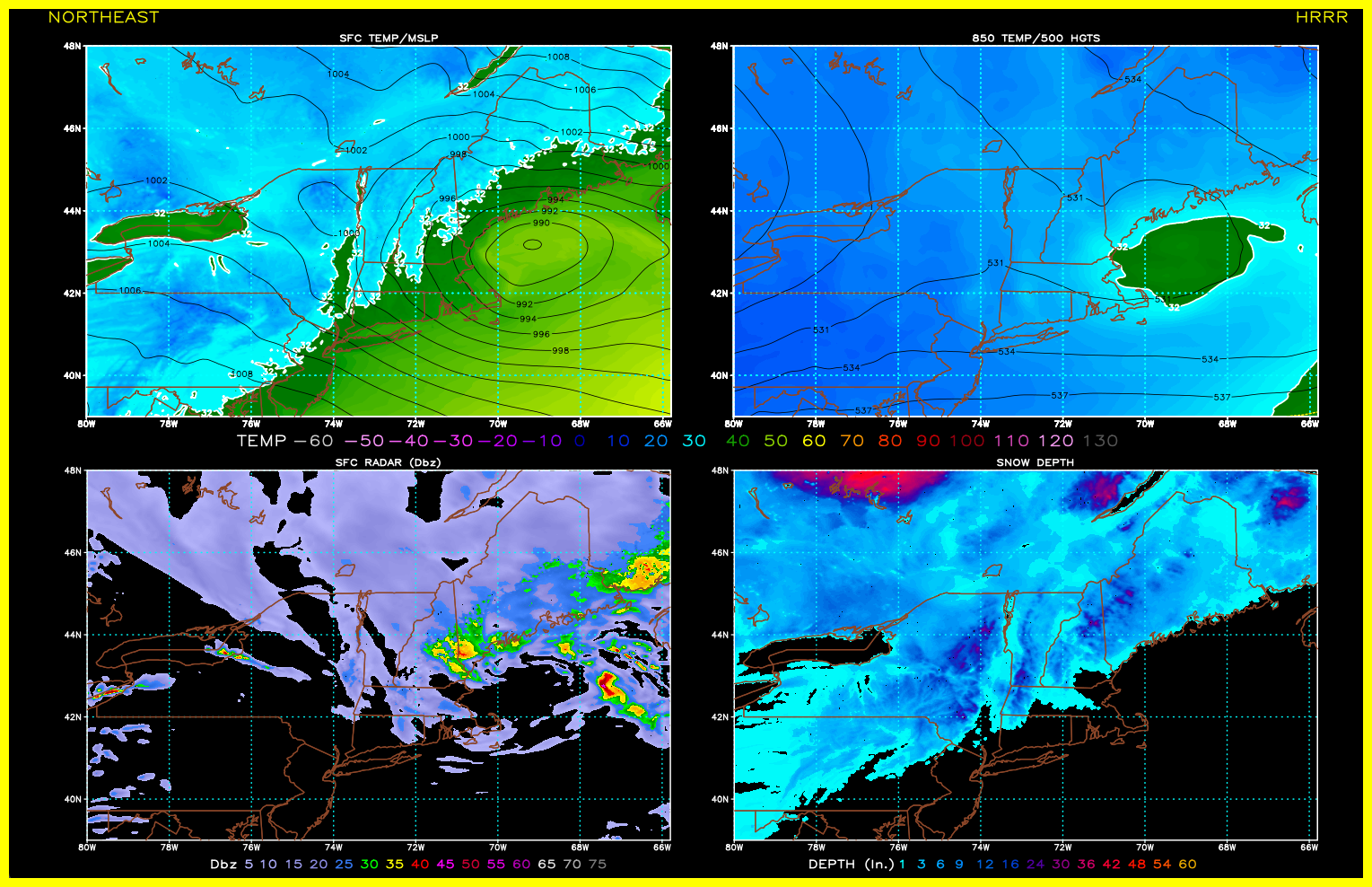
Preliminarily ... a medium impact partial Miller B, Friday
ROOSTA replied to Typhoon Tip's topic in New England
12z HRRR Initialized To t 49 Not much gain in the snow department. NEXT

-
Just bend-over easy. I mean break 'em easy. It's officially a Big-Dog Zeus is in the house!
-
George001, Slow down buddy. You're getting way out ahead of your skies. Odds of verification <10%. There's about 30 model runs before it should be taken seriously. Strong signal, yes but all your doing is setting yourself up for a let-down. Read more, play the devil's advocate, ask self what could go wrong? Play it conservatively till it's inside D5.
-
The big ones most always present themselves with a huge signal even in LaLa Land. Anything close to verifying would be Major...details to be worked out.
-
Preliminarily ... a medium impact partial Miller B, Friday
ROOSTA replied to Typhoon Tip's topic in New England
Just looked at the 12z GFS. Looks like some good frontogenesis at the height of passage. Temps look a bit high at 850, 925 include surface out to about ORH, that could be where the CF sets-up. Surface reflection tracking a little too far N and W but might be enough time to correct for a score. Going to be close. haves to have nots with a huge gradient. -
Preliminarily ... a medium impact partial Miller B, Friday
ROOSTA replied to Typhoon Tip's topic in New England
Appears there is still hope for the Coastal Plain. Trends look promising. I only have a frontal passage with what their calling a temperature "plunge" 80 to 65F. A slight chance of severe mid-day tomorrow. -
Preliminarily ... a medium impact partial Miller B, Friday
ROOSTA replied to Typhoon Tip's topic in New England
12z NAM A little Paintshop Fun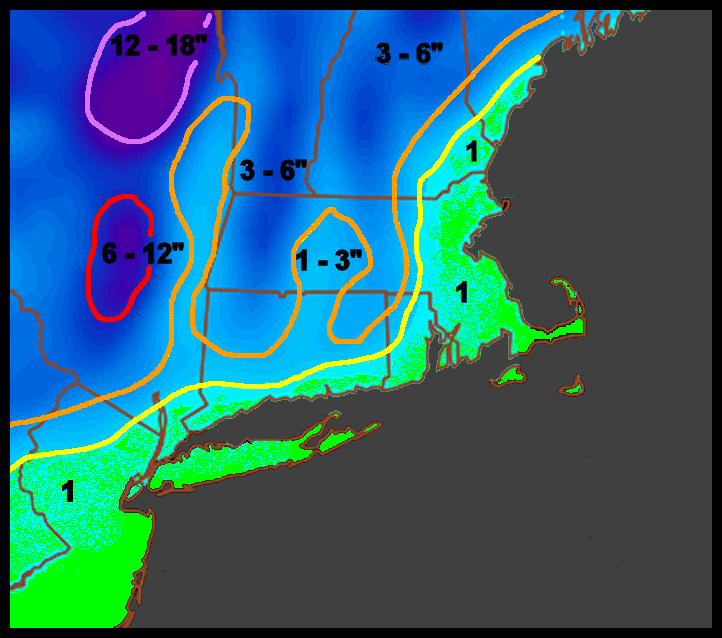
-
Preliminarily ... a medium impact partial Miller B, Friday
ROOSTA replied to Typhoon Tip's topic in New England
For the sanity of many a whiff could be the best medicine. Blasphemy! Just accept if you don't have a combo of LAT and elevation this isn't the storm. NEXT -
Personal observations analyzing R2R models. Comparing knowing the individual bias of each. ML's are torch city ATT. Parent Low doesn't transfer the energy in time to get the Coastal cranking. #1 Rule on Miller B's (circa 2010) Somebody is always going to get screwed. #2 As long as it's not a Miller Lite Discussed Ad nauseum. Miller A vs Miller B - New England - American Weather (americanwx.com)
-
It's going to be a lonnnggg week ahead. The emotional Roller-coaster of despair to elation. The "storm" is exactly why it's the best group of Weeners out there and when this forum shines. I'll state the obvious. Go ensembles, watch the trends AND avoid the pissin as-to-say from the OP's until Wednesday. Let the freak flags fly. Read more from the METS, try to keep the IMBY bellyaching to a minimum. It doesn't look bad for a crush-job.
-
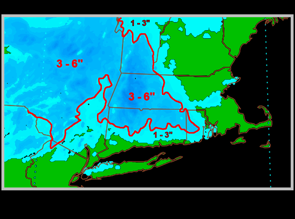
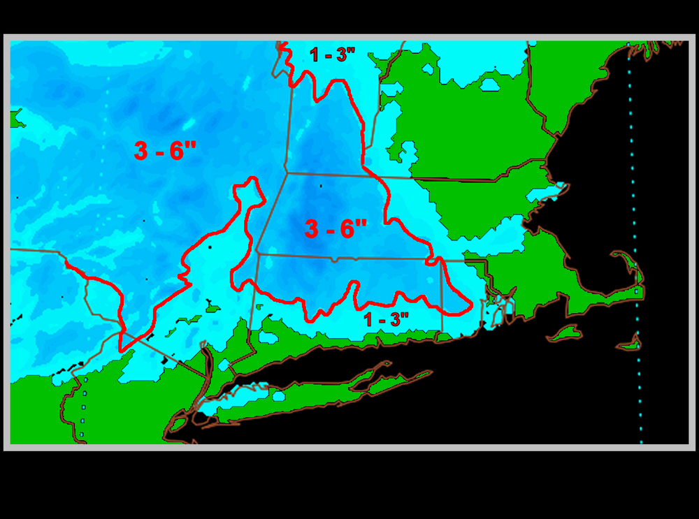
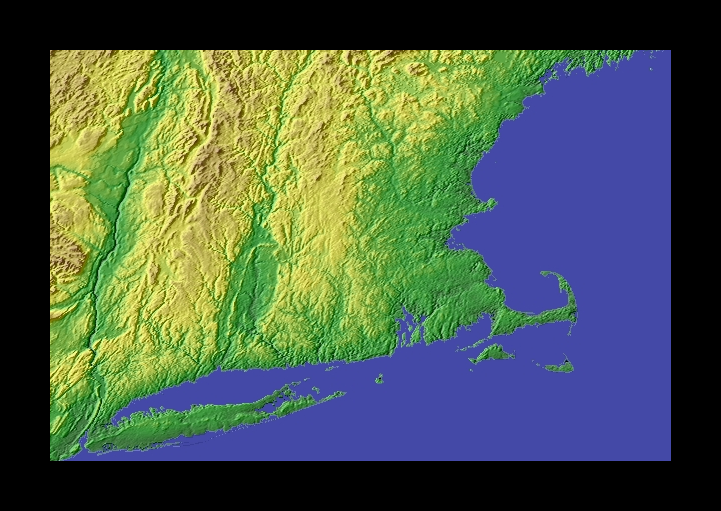
And there you'll find the nice 3-6" accumulations, maybe a lolli or two, max in around 8" probably somewhere in Tolland County. Wanna bet? It has never snowed where I live. I find that hard to believe because flurries have been recorded in the Keys. All I want for the Holidays is a flurry. Y'all are spoiled
-
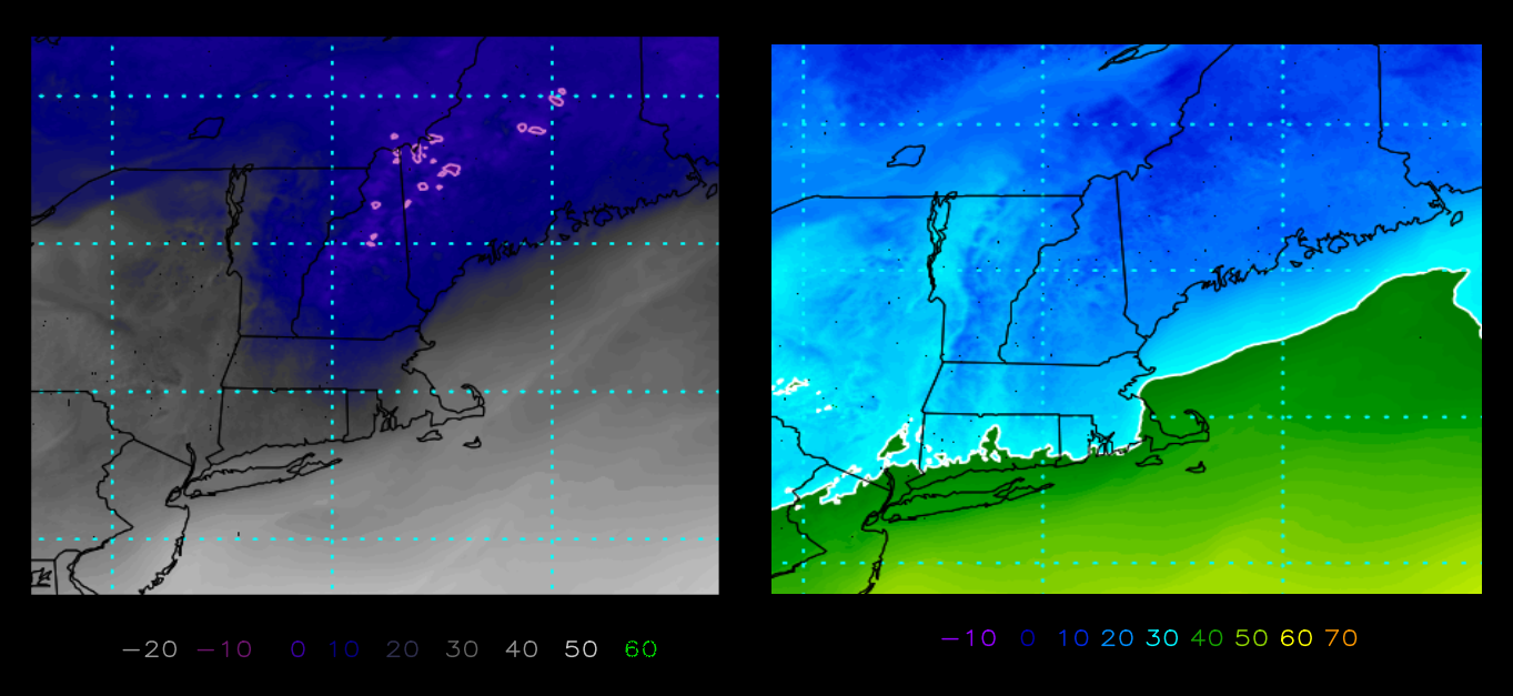
A LITTLE DRY OUT THERE. Teens and twenties. Question is: Does the column saturate in EMA?

-
With that OES banding in PLY County. I can recall cweat going from exit-to-exit reporting conditions. Some white lawns down that-away!
-
The obligatory weenie snow map Latest HRRR
-
Great pictures many familiar, many have never met. Someday... one of the first gtg was on CC for Noel in Oct, 2007. Combo gathering and chase. Always good times meeting! Meanwhile bring on WINTER.
-
Any SNOW is good SNOW! I'd be going to the GTG in a heartbeat only if I lived 1k miles closer. Today I can envision the uproar when the 12z comes rolling in reminiscent to the gathering in the South-end of Boston years ago, (almost booted out) LOL
-
December rarely delivers the goodies. Disappointment waits for those who think so. It's more a transition Month for most of the time in the three southern states. Cashing-in Winter because of a bad early start? All it will take is one or two blockbusters in a 6–8-week timeframe. I used to despise the 1-3" pinpricks, hours of wasted time for what? Someone should post soundings for assorted cities by model and run time. First place, well maybe second or third place in a storm threat to look at. Crunch time it's soundings less the slam-dunks.
-
Multiple threats going forth, staggered sleeping, run to run nuances to diagnose, TILL FURTHER NOTICE! There's a widespread big one in there. Probably before the New Year. Great looking pattern for New England.
-
So much, more and more as the years pass. Almost as if "why bother posting anything useful?" Such are the times of free speech. Other than that,.. IT GON SNOW maybe, might, could it be. I'll awake when the 1ft'r threatens. Oh, by the way it was 80F here today. I gots to move!
-
Stakes rising with every model run. In years past many a threat has come and gone. I'm getting antsy! Seems the time invested (Climo Winter) 3 months' worth of... just doesn't seem to pay off. One can surmise "winter" is a month's timeframe. Early Jan. to mid Feb., and for myself it's always been the chase, still holding on to my bias. I'm ready, going forth (curse of death) may "we" all get the fix we deserve and want.
-
Instead of waiting, wanting, wishing for first snow. Y'all (I think that's how to say it) come on down to the Cape and watch the most powerful rocket launch into the heavens. It's 60 miles to my ESE. Put it on your bucket list, most assured you will not be disappointed. Appearing first snows for most is going to have to wait. This is not the event.
-
As in Spring also in Fall, elevation will be a determining factor as a general rule.
-
Wind gusted to 100mph. atop Artemis. I'm getting frequent gusts in the 60 range. Oh, that sound a ferocity greater than Ian. Power going out all over the place.
-
TS wind field. HUGE On the current forecasted track my location will be in the RFQ for an extended period of time. I'm about 40miles W. abeam of DAB. Already observing gusts in the 30mph range