high risk
-
Posts
2,801 -
Joined
-
Last visited
Content Type
Profiles
Blogs
Forums
American Weather
Media Demo
Store
Gallery
Everything posted by high risk
-
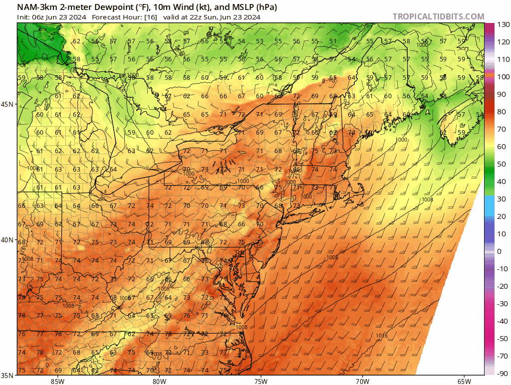
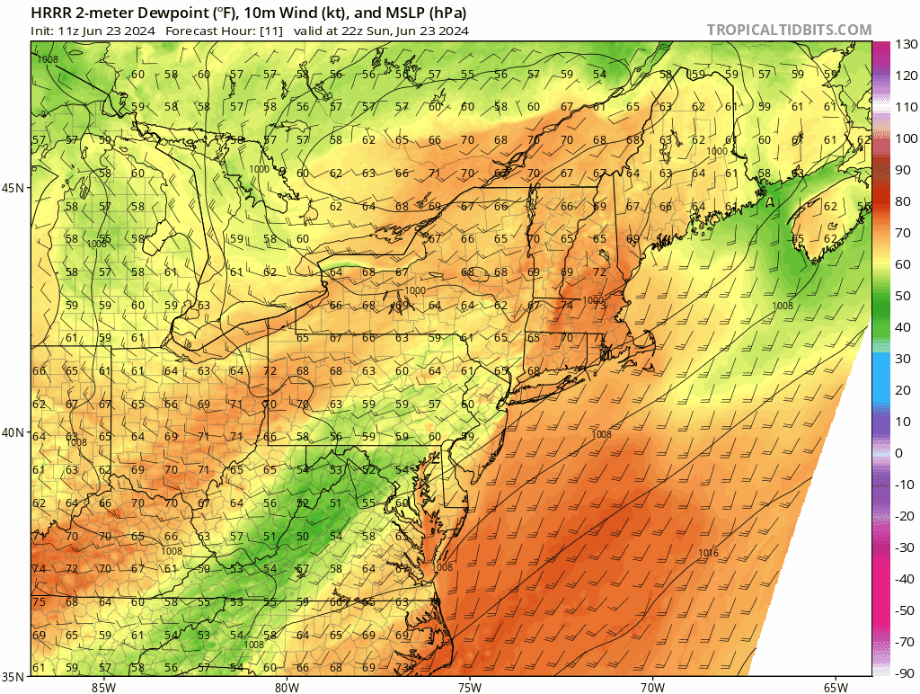
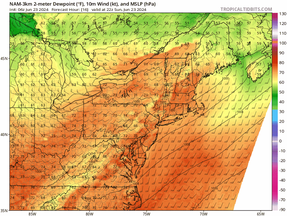
Yep. You have to toss the HRRR solutions, because it has no instability to work with when it tries to initiate convection.
-
Maybe. The HRRR is on its own with such an early round 1. Its doing weird things with the mixing again, but I'm not sure if that is driving the early show, or if it's just different handling of the forcing. If things hold off until later when the shear increases, I think there is some higher end wind potential. Heck, if just we boost the dew points in the HRRR but keep its timing, the still sizable downdraft CAPE might overcome the weak shear and give some pockets of higher winds.
-
Correct. The HRRR is the earliest with convection, and the shear won't increase until later in the day, so its early afternoon storms are not exciting. That said, I'd take its solution in a heartbeat, as it has multiple rounds of storms and good rainfall. The 18Z NAM Nest has severe storms, as it waits until later when the shear has improved a lot, but some people (me!!!) miss out, and there is no round 2 later in the evening or overnight. That run legitimately pissed me off.
-
One problem, though, is that the better flow aloft seems to be lagging behind and may arrive until after the front passes. Still, I would take the GFS timing of the shortwave. The 00Z NAM timing is slower, which is not what we want for this system.
-
The HRRR definitely won't be right, but even the NAM Nest lowers dew points a couple of degrees this afternoon (before a rise again later in the day). Mid-level temps are fairly warm, so if there is some truth to the idea of mixing, but at a far lower magnitude than shown by the HRRR, that could make the difference between convection firing or not.
-
This is what we call a "difference of opinion"
- 1,696 replies
-
- 8
-

-
- severe
- thunderstorms
- (and 5 more)
-
I think that our best bet for severe and more widespread coverage is the scenario shown by both the 12/18Z NAM Nest. Storms fire in the mid to late afternoon along some sort of pre-frontal trough and get organized as they sweep east, in an environment with modest shear and good downdraft CAPE. At least some coverage of damaging winds would be likely. A second line tries to form behind it a few hours later, but that affects areas generally east of I-95. The HRRR goes for a couple of rounds in the early to mid evening, which would be great for rainfall potential, but the fact that the reflectivities are low and the rainfall is super light give me a lot of doubts about that scenario.
- 1,696 replies
-
- 7
-

-
- severe
- thunderstorms
- (and 5 more)
-
Sunday has some potential, I guess, although flow looks to be very light. But I guess that there would be a localized downburst threat with the deep, well-mixed boundary layer. One thing I don't like: the signal seems to be focused more east of here, and I've seen too many scenarios in which storms initiate over us but don't really mature until cross the Bay. At this point, though, I just want some freaking rain.
- 1,696 replies
-
- 2
-
-
- severe
- thunderstorms
- (and 5 more)
-
Interesting that Dulles has been at 59 for a couple of hours now.
-
KDCA dew point is still 68, but KBWI and KIAD have dropped into the low 60s
-
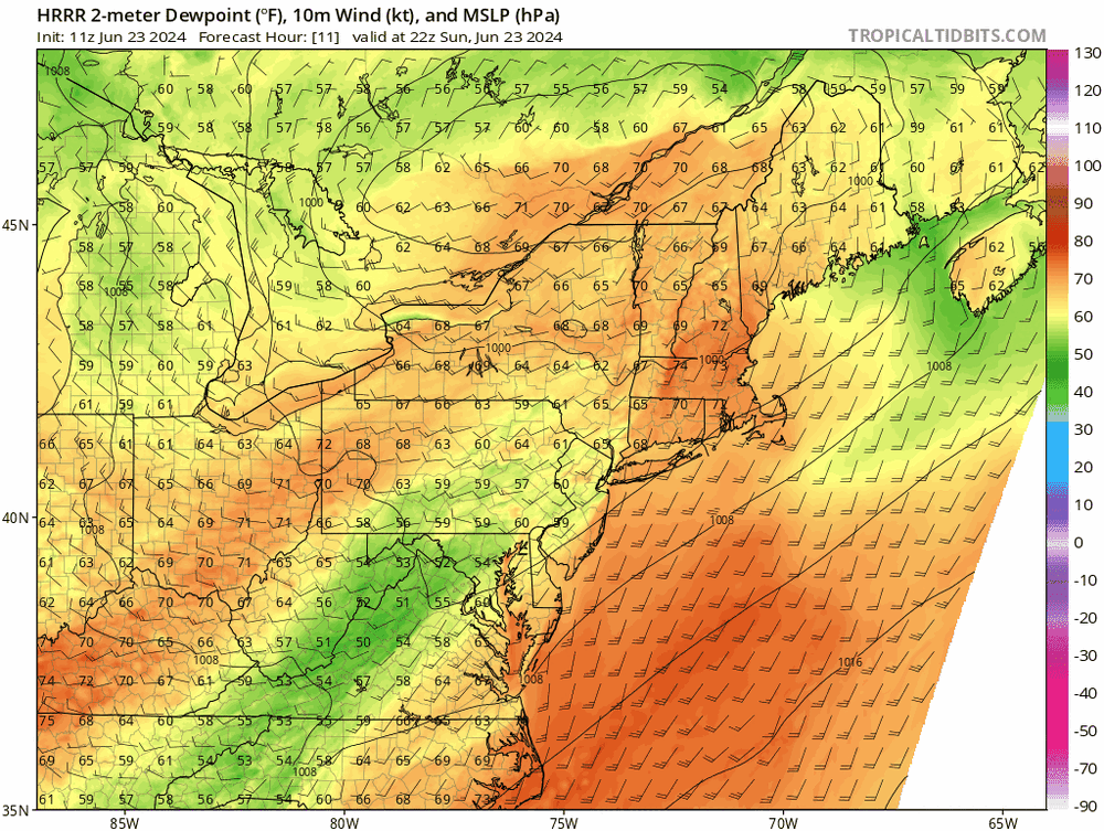
Trend in the CAMs for today has not been good. Falling dewpoints ahead of the front and lack of convergence seem to be the problems. I think that the key is to watch the dew points - are they really going to fall into the low 50s this afternoon area-wide as shown by the HRRR? (FWIW, the HRRR is likely overdone with the mixing, maybe by a lot, but I'd be surprised if dew points don't fall for a while. All of the other CAMs have the dew points falling - just not nearly as much as the HRRR does.)
-
Really interesting that they changed the Montgomery County tornado into 2 separate paths instead of a single 26 mile path, but based on the reports on that map, it's clear that there was an occlusion (left turn) as the tornado approached Gaithersburg, with a new tornado forming quickly to the east.
- 1,696 replies
-
- 1
-
-
- severe
- thunderstorms
- (and 5 more)
-
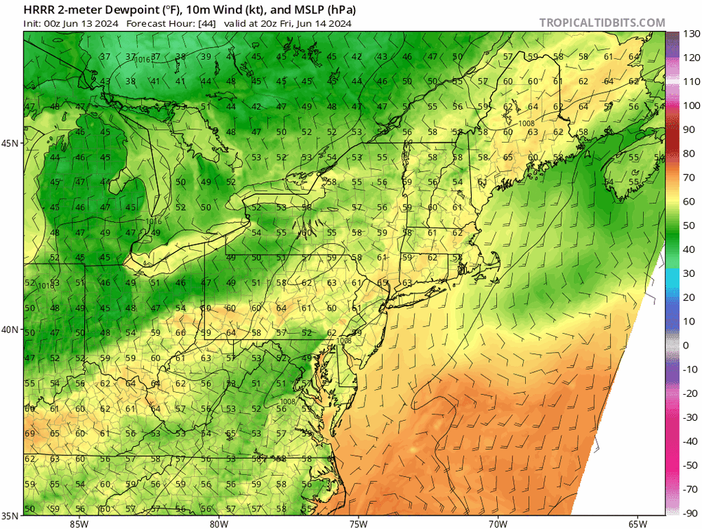
Really interesting forecast for later Friday. Deep layer shear is adequate for severe, but there are big differences in moisture evolution. There is a lot of agreement that there will be some strong low-level drying in the early afternoon (mixing? downsloping? subsidence?), but the extent of the drying differs a lot among the models: Both forecasts have a local min in the DC area with higher dew points surrounding that min; they both moisture things back up later in the afternoon as the front approaches. The HRRR, however, can't recover enough from that pretty serious drying (both in magnitude and coverage), while the NAM Nest has "less work to do" to get dew points back up into the mid to upper 60s by the time convection tries to initiate. I'm pretty sure that the HRRR is significantly overdone, but if it's at all on the right track, frontal convection will struggle. If we can moisten up by late afternoon, it would probably be a SLGT risk day.

- 1,696 replies
-
- 4
-
-
- severe
- thunderstorms
- (and 5 more)
-
Agreed, but I was I was feeling pretty good about frequency of general thunderstorms this year up until early May. I think I had heard thunder 5 times before May 1, and there was one year a few years ago (2020?) when I didn't hear my first thunder until the first week of May. But it has certainly been a disappointing May and first 10 days of June.
-
It's *possible*, but right now, 1) the GFS mixes out the already-limited low-level moisture 2) the flow is somewhat downslope ahead of the front 3) the height falls are all north of here Still time, I suppose, for things to trend better. I did well on rainfall on Wednesday, but it's going to dry out quickly here.
-
The LWX forecast has some showers and storms around later this evening, but the CAMs show that initiation will occur much earlier. Not expecting widespread coverage or any concern about severe, but it looks like it be more active later today than initially thought.
-
Friday definitely looks steamy (the Euro is the hottest, but all guidance seems to be in the 90s for most of the area), BUT there seems to be growing agreement that a cold front will roll through Friday evening, bringing in a lovely air mass for next weekend. The GFS has been leading the way with that idea, and other guidance seems to be either explicitly showing that or trending towards it.
-
Not to trivialize the environment that was in place, as it clearly supported tornadoes, but that sounding had 78/77 at the surface; that dew point value was significantly higher than any value in the area and contributed to the supposed great CAPE. I don't consider that a reasonable representation of the instability anywhere in the area at that time. 4000 CAPE would have led to many instances of large hail.
- 1,696 replies
-
- 3
-

-
- severe
- thunderstorms
- (and 5 more)
-
very respectable (but sub-severe) outflow here in southern Howard County
- 1,696 replies
-
- 2
-
-
- severe
- thunderstorms
- (and 5 more)
-
The SLGT risk should have been drawn farther west. As suggested by the MD, the severe box will likely include at least some of the counties along I-95 in Maryland.
- 1,696 replies
-
- 3
-
-
- severe
- thunderstorms
- (and 5 more)
-
Things definitely trended faster with the boundary overnight. Recent HRRR runs look slightly slower again - we'll see if the storms fire just west of I-95 or just east of it
- 1,696 replies
-
- 1
-
-
- severe
- thunderstorms
- (and 5 more)
-
I think that tomorrow will be a SLGT for most of the area except western and far northern counties. Good agreement now among the CAMs that storms will erupt along the front early tomorrow afternoon in an environment with decent shear and instability.
- 1,696 replies
-
- 6
-
-
-
- severe
- thunderstorms
- (and 5 more)
-
That dew point is high, but the LCLs were clearly very low, and the low-level shear was quite respectable.
- 1,696 replies
-
- 3
-
-
- severe
- thunderstorms
- (and 5 more)
-
My lawn is super thirsty, so I'm pleased to see the CAMs coming into agreement for two rounds of storms tomorrow (late afternoon and late evening) for a lot of us, especially on the north side of DC.
-
It's not a great setup, but in the department of beggars being unable to be choosers, Wednesday seems to have potential to be a MRGL risk day here.
- 1,696 replies
-
- 4
-
-
- severe
- thunderstorms
- (and 5 more)