high risk
-
Posts
2,801 -
Joined
-
Last visited
Content Type
Profiles
Blogs
Forums
American Weather
Media Demo
Store
Gallery
Everything posted by high risk
-
The signals there are encouraging for sure, and it's indicative of a chance of beneficial rains for a larger part of the area that's higher than we've seen in a while. The worry, though, is that these are the low-res models that aren't suited for capturing mesoscale details, and the CAMs show that despite what looks like a soaking for everyone in the global models, this will still be an event with winners and losers.
-
I wasn't paying attention to the location of that boundary at the time, but it's certainly possible in theory.
-
It's really getting its act together on the east side of DC, but that's far too late for those of us further west and northwest.
- 1,696 replies
-
- 2
-

-
- severe
- thunderstorms
- (and 5 more)
-
I'm pretty shocked by the lack of intensity and lack of lightning.
- 1,696 replies
-
- 2
-
-
- severe
- thunderstorms
- (and 5 more)
-
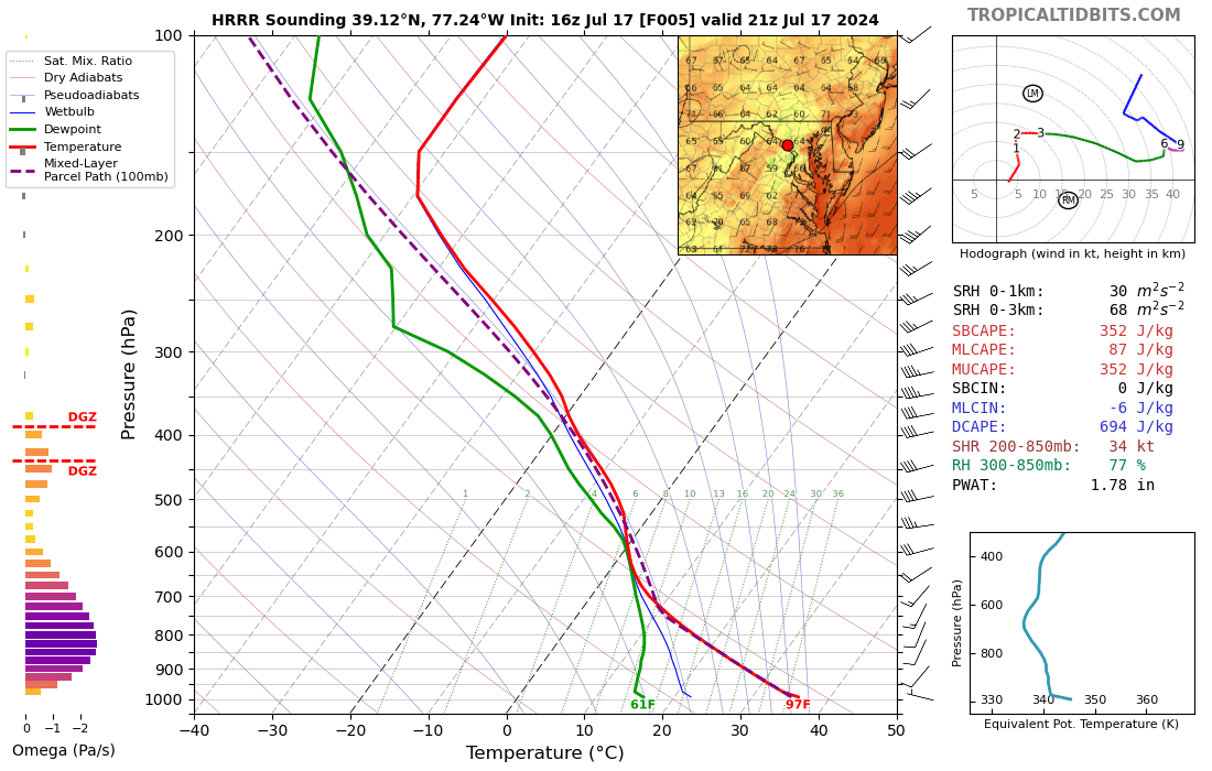
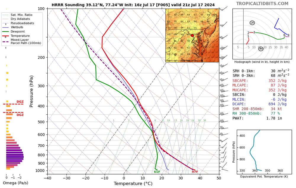
Absolutely. The HRRR is capturing the forcing and initiating convection, but because of the extreme issue with low-level drying, it can't possibly generate widespread, intense storms. This is the environment it has the storms moving into: With that low of a surface dew point, it can't possibly show impressive storms, but we all know that the actual dew point will be at least 5 degrees higher.
-
I understand questioning the watch, given the dry antecedent conditions, but I don’t understand the comment about most guidance giving us no rain. Toss the HRRR completely, because it’s doing its usual overmixing thing here and drops our dew points into the 50s this afternoon. The rest of the CAMs all have a heavy rain signal *somwhere* in the metro area and suggest a training scenario.
-
HRRR again reduces dew points into the upper 50s this afternoon. The fact that it's still able to generate a weak line in that environment certainly suggests that there will be forcing available to work with the "real" instability.
- 1,696 replies
-
- 4
-
-
- severe
- thunderstorms
- (and 5 more)
-
That midwest derecho won't make it here, but the CAM signal for widespread convection Wednesday in a fairly healthy environment is quite strong in this evening's runs. Would think we should wake up to a Day 2 SLGT in the morning.
- 1,696 replies
-
- 8
-
-
- severe
- thunderstorms
- (and 5 more)
-
This seems super unlucky. I got 0.35" from this evening's batch.
-
For sure. I think that western areas have the best chance of heavy Wednesday evening convection, and areas east have the best chance of the steadier Friday rain. That in-between zone along I-95 could get screwed on both (although we could “win” on either or both too).
-
Getting really concerned about trying to get meaningful rainfall this week. It’s still on the table, but it’s far from a sure thing, and lowering model QPF reflects that. It looks like 2 chances: 1) a line of convection on the front Wednesday evening which has potential for big localized totals, but will there be breaks in the line, and might it weaken if it arrives too late? 2) moisture moving from coastal areas back to the northwest Friday. The best rains will be east and southeast of us, but can we still get a modest soaking? Models now still have us within the “good” rain, but we’re getting dangerously close to the back edge, and any further shift east could really screw us. I wouldn’t want to be too far west of DC, as things currently look, for round 2.
-
Credit the CAMS which were hinting at a few showers developing along the front after dark. Heavy downpour in the Columbia/Ellicott City area.
-
They're dry, but I wouldn't say "suddenly". Things have been trending towards very limited coverage over all runs from the past couple of days. Still some small chance this evening, but I don't see how we generate storms tomorrow with lowering dew points and (light) north winds.
-
Several consecutive HRRR cycles show convection, focused mainly northwest of I-95 but with some possibility for those further east in central and northern MD, after dark.
-
MRGL for the 4th. There will be convection in the area later in the day, but shear is really meh. Still, with a hot, well-mixed boundary layer, a few stronger wind gusts can't be ruled out. What's interesting is that there is a a weak consensus for this being an event for DC and points south, but there are still a few CAM solutions that get points north of DC in on the action too.
-
Sign us up for tonight's GFS. Everyone in the forum scores, but Howard County gets drowned.
-
CAMs have swung back and again look decent for the I-95 corridor, BUT those solutions are contingent upon heating into the 90s. It does look like there is some clearing approaching, and I would expect us to rapidly torch if the sun emerges, but we'll see how this plays out.
- 1,696 replies
-
- 12
-
-

-
- severe
- thunderstorms
- (and 5 more)
-
I'm right on the edge and getting massively disappointed. It's worse, because the 00Z CAMs took a huge step in the wrong direction for tomorrow.
-
Huge spread in CAM solutions for both today and tomorrow. After looking at the HRRR and NAM Nest, I was ready to write off severe potential this evening and hope for a weakening area of storms to arrive from the northwest later tonight. But all 3 HiRes Windows have significant convective signals for the early evening hours with modest instability and deep-layer shear (and even a bit of low-level shear, if you're really feeling frisky). Do we trust the 2 better models or the agreement of the other 3? For Sunday, being further south and east will ramp up your severe probabilities considerably, but there is still a healthy overall signal for the I-95 corridor in an environment with stronger instability and deep-layer shear than today.
- 1,696 replies
-
- 15
-
-
-
- severe
- thunderstorms
- (and 5 more)
-
Of course, right after I blow off Saturday, the 12Z HRRR pulls me back in with an impressive convective evolution for northern MD with some interesting wind profiles.
- 1,696 replies
-
- 3
-
-

-
-
- severe
- thunderstorms
- (and 5 more)
-
Yeah, I'm still worried about this being an Eastern Shore show on Sunday - hoping that the slower trends continue.
- 1,696 replies
-
- 1
-
-
- severe
- thunderstorms
- (and 5 more)
-
Other than a couple of isolated morning showers and maybe a few dying late evening showers, I'm not seeing a lot of legit rain chances on Saturday unless something changes. I've resigned now to pulling for Sunday. I was surprised to the SLGT, but the Euro is much slower with the front, and the GFS/GEFS seem to be trending that way. Would be a decent SVR (and possibly a heavy rainfall) event Sunday if the slower front idea is correct.
- 1,696 replies
-
- 4
-
-
-
- severe
- thunderstorms
- (and 5 more)
-
The timing of the front looks awful. We need it to slow down, as a Sunday morning frontal passage won't bring the goods, and we'll watch things like up for the beaches of MD/DE/southeast VA. Our best hope is that there are indications of a modest lead shortwave Saturday evening. Organized storms may fire Saturday afternoon to our west/northwest and roll through during the evening.
- 1,696 replies
-
- 3
-
-
- severe
- thunderstorms
- (and 5 more)
-
Only if the main show fizzles out too, which looks unlikely. The models had the idea of forcing for a small-scale round 1, but they put it in northern MD instead of southern. They've been very consistent about a more widespread area of storms rolling in from the west later this evening, and that appears to be on track. If the models are off and that craps out, then a post-mortem will be needed.
- 1,696 replies
-
- 5
-
-
- severe
- thunderstorms
- (and 5 more)
-
There is actually some very solid agreement now in the 12Z guidance. There is a round 1 in the 21-23Z time frame which has a cluster or broken line of cells, focused mostly north of DC, which would have some significant wind potential. There is then a more widespread round 2 later in the evening that would bring welcome rain to most of the area.
- 1,696 replies
-
- 4
-
-
- severe
- thunderstorms
- (and 5 more)