high risk
-
Posts
2,801 -
Joined
-
Last visited
Content Type
Profiles
Blogs
Forums
American Weather
Media Demo
Store
Gallery
Everything posted by high risk
-
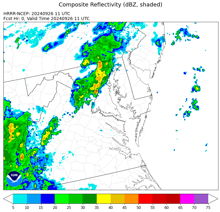
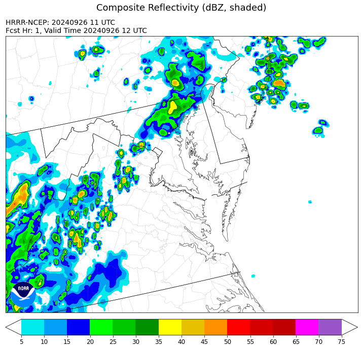
Exactly. Even when the HRRR initialized it well: It dramatically weakened within only one hour: When this happens, it's a clear indication that the forcing to drive the rain area is largely not being captured in the model. It has no reason to think that heavy, organized rain should be there, and it works to wipe it out.
-
Definitely not handled well at all by the guidance. Closing in on 1” here.
-
Already 1/3 of an inch here, and I haven't even gotten into the "good stuff" for more than a few minutes. This is not how convection usually behaves here after dark, but the shortwave looks great in the guidance. Should be some very impressive totals in north-central and northeast MD overnight.
-
Heavy 11pm shower at my home. The main batch up in PA looks to be headed for northeast MD. We'll see if there is back building on the western flank as it comes south.
-
The best shot at a soaking in the Baltimore area was always round 2, after midnight. Last several runs of the HRRR really like central and northeast MD.
-
That’s my worry for sure, but we still have a shot at something from the evening batch.
-
I'll say this: with that NAM3 focus of heaviest rain, there is some (but not complete) model agreement for northeast MD to get soaked early Sunday
-
Seems to be some modest model agreement in a small MCS (or closer of cells) coming into the DC area in the very late afternoon or early evening hours. Perhaps less certainly for north-central Maryland. Second batch of showers, covering some part of the area, towards sunrise.
-
Agreed. Looks more like a Saturday frontal band now, and while it does appear to have decent moisture and convergence, such that we might maximize its potential, it's not the overrunning soaker we wanted.
-
I understand the SLGT, but it's highly conditional, as several of the CAMs are a shutout for most of the area. It would be a late threat if it materializes, possibly after sunset for the central MD crew.
-
1.15” in southern Howard County
-
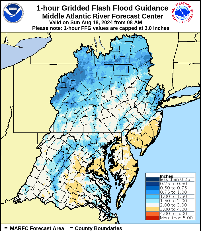
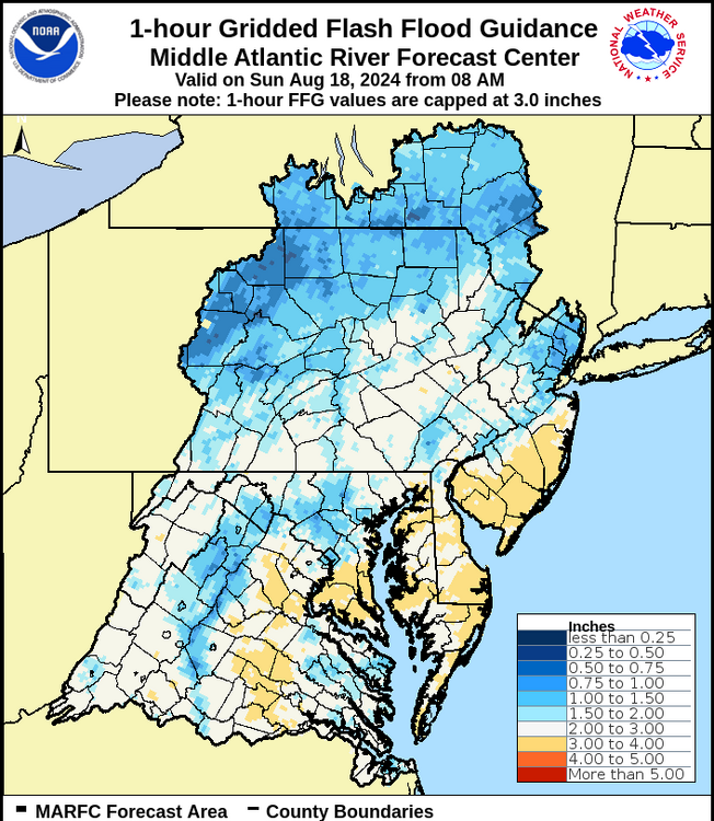
Yes, the labeling shows that the product covers today, and it absolutely does include recent precip and accounts for the fact that some areas can achieve flash flood risk more than others (independent of recent precip).
- 1,696 replies
-
- 1
-

-
- severe
- thunderstorms
- (and 5 more)
-
Would only take about 1" in an hour to cause problems in parts of the area, per flash flood guidance. That seems achievable, even if storms are progressive.
-
Can confirm that it's absolutely pouring in southern Howard County with a good amount of lightning
-
Also, a secondary cold front is passing through - the leading air of the truly drier air mass. Dew points were still in the upper 60s today.
-
Tomorrow will be better than it has been, but dew points may still be in the mid or upper 60s. A second front goes through Saturday evening (HRRR blows up a batch of showers), and then the real dry air arrives Saturday night.
-

Tropical Storm Debby: Mid-Atlantic Impacts
high risk replied to WxWatcher007's topic in Mid Atlantic
Over 2" at my place a few miles south of yours. -
Tropical Storm Debby: Mid-Atlantic Impacts
high risk replied to WxWatcher007's topic in Mid Atlantic
This band is the real deal in terms of rainfall. Lightning and thunder too. -
Tropical Storm Debby: Mid-Atlantic Impacts
high risk replied to WxWatcher007's topic in Mid Atlantic
Worth noting that the model gust products (at least for the American models, not sure about Euro) are showing a gust potential, not necessarily what will mix down. If there is high wind speed in the PBL, and it's ever so slightly unstable at the surface, it will mix a chunk of that momentum to the ground. I'm unconvinced that we'd mix efficiently in the tropical air mass, but I guess we'll see. -
Tropical Storm Debby: Mid-Atlantic Impacts
high risk replied to WxWatcher007's topic in Mid Atlantic
I'm not too concerned about winds, except for the EF-1 tornadoes on Friday. -
Tropical Storm Debby: Mid-Atlantic Impacts
high risk replied to WxWatcher007's topic in Mid Atlantic
I get what you're saying, with the seeming growing likelihood of the core synoptic rains shifting west, but there will be a multi-day period of very high PW values over the Mid-Atlantic with waves of scattered convection. There will absolutely be areas that get a ton of rain, and even some that will get a ton of rain before the "main day" on Friday. -
Tropical Storm Debby: Mid-Atlantic Impacts
high risk replied to WxWatcher007's topic in Mid Atlantic
Yeah, Friday will be a convective deluge in the warm sector. We'll see if the NAM is correct with the western track, although it does have the support of the Euro -
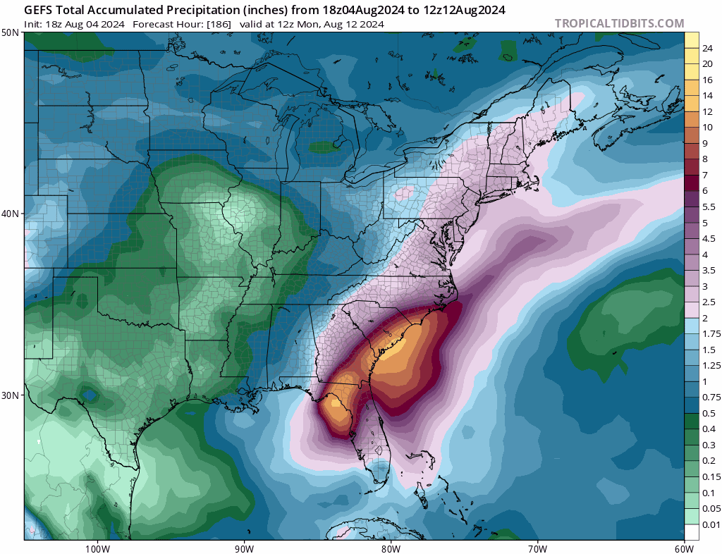
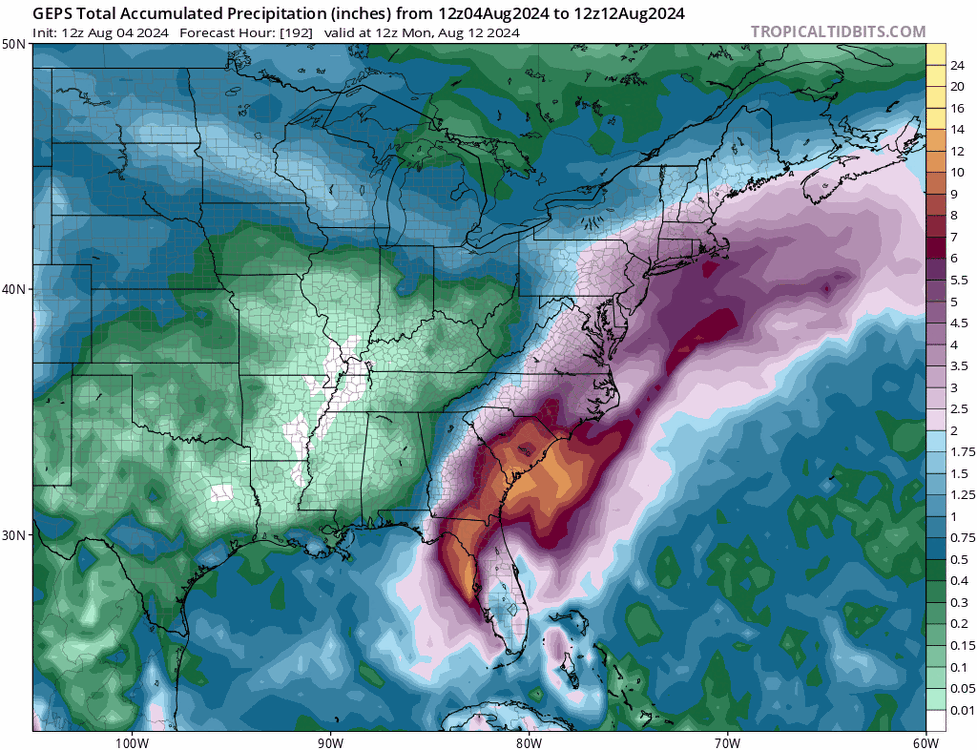
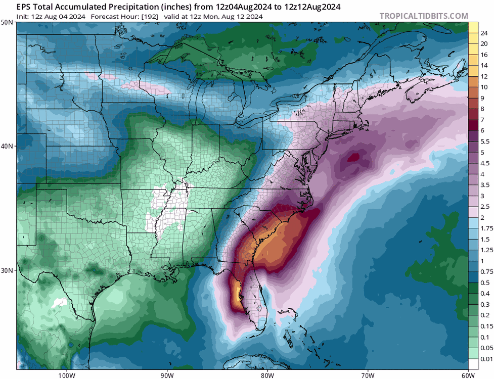
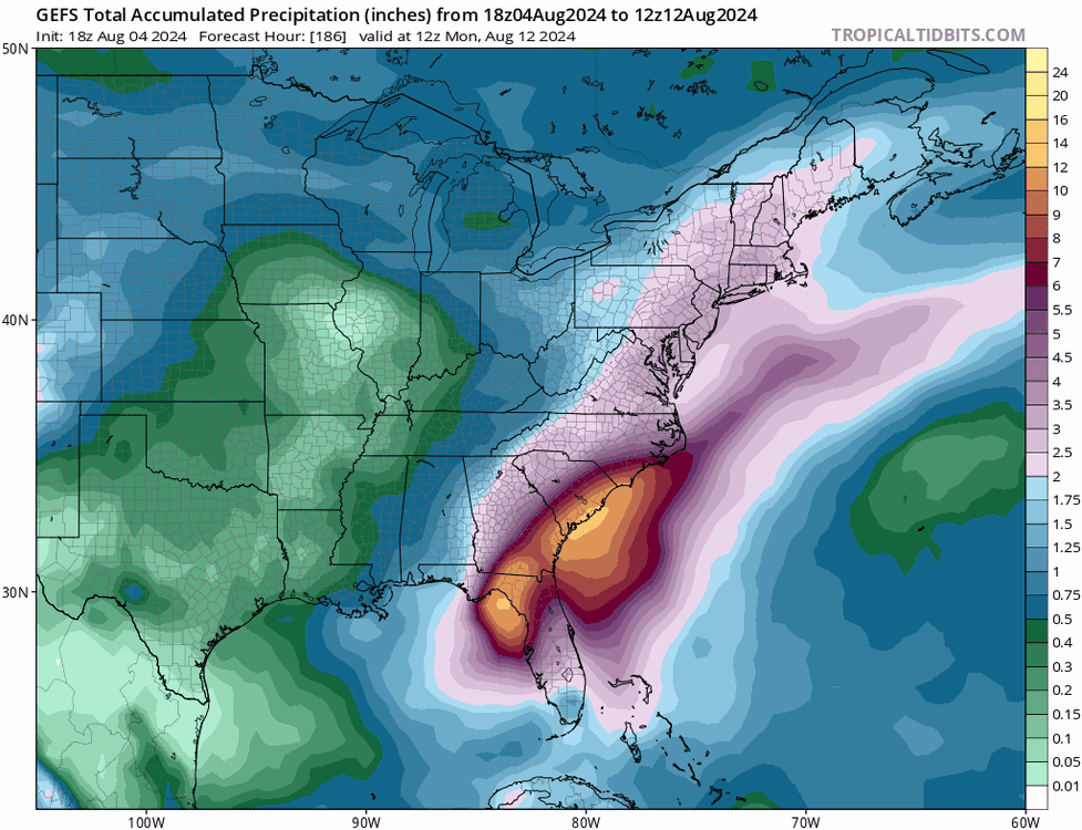
While the many individual members take multiple different paths to get there, the ensemble means for precipitation through the end of next weekend are all very wet for our area, without the east-west gradient seen in some recent deterministic solutions.
- 755 replies
-
- 13
-

-
Several CAMs have isolated moist blobs late Monday as well.
-
looks like perhaps an MRGL for Thursday
- 1,696 replies
-
- 5
-
-
- severe
- thunderstorms
- (and 5 more)