high risk
-
Posts
2,802 -
Joined
-
Last visited
Content Type
Profiles
Blogs
Forums
American Weather
Media Demo
Store
Gallery
Everything posted by high risk
-

2020 Mid-Atlantic Severe Weather - General Thread
high risk replied to Kmlwx's topic in Mid Atlantic
alarming, to say the least. But the HRRR and HiResWindow ARW2 still like DC and areas north. -
2020 Mid-Atlantic Severe Weather - General Thread
high risk replied to Kmlwx's topic in Mid Atlantic
time to invoke this forum's scale for level of interest by user. It won't be any sort of high end day for sure, but I'm still feeling good about some organized line segments with severe potential tomorrow. -
2020 Mid-Atlantic Severe Weather - General Thread
high risk replied to Kmlwx's topic in Mid Atlantic
yep. about 70. -
2020 Mid-Atlantic Severe Weather - General Thread
high risk replied to Kmlwx's topic in Mid Atlantic
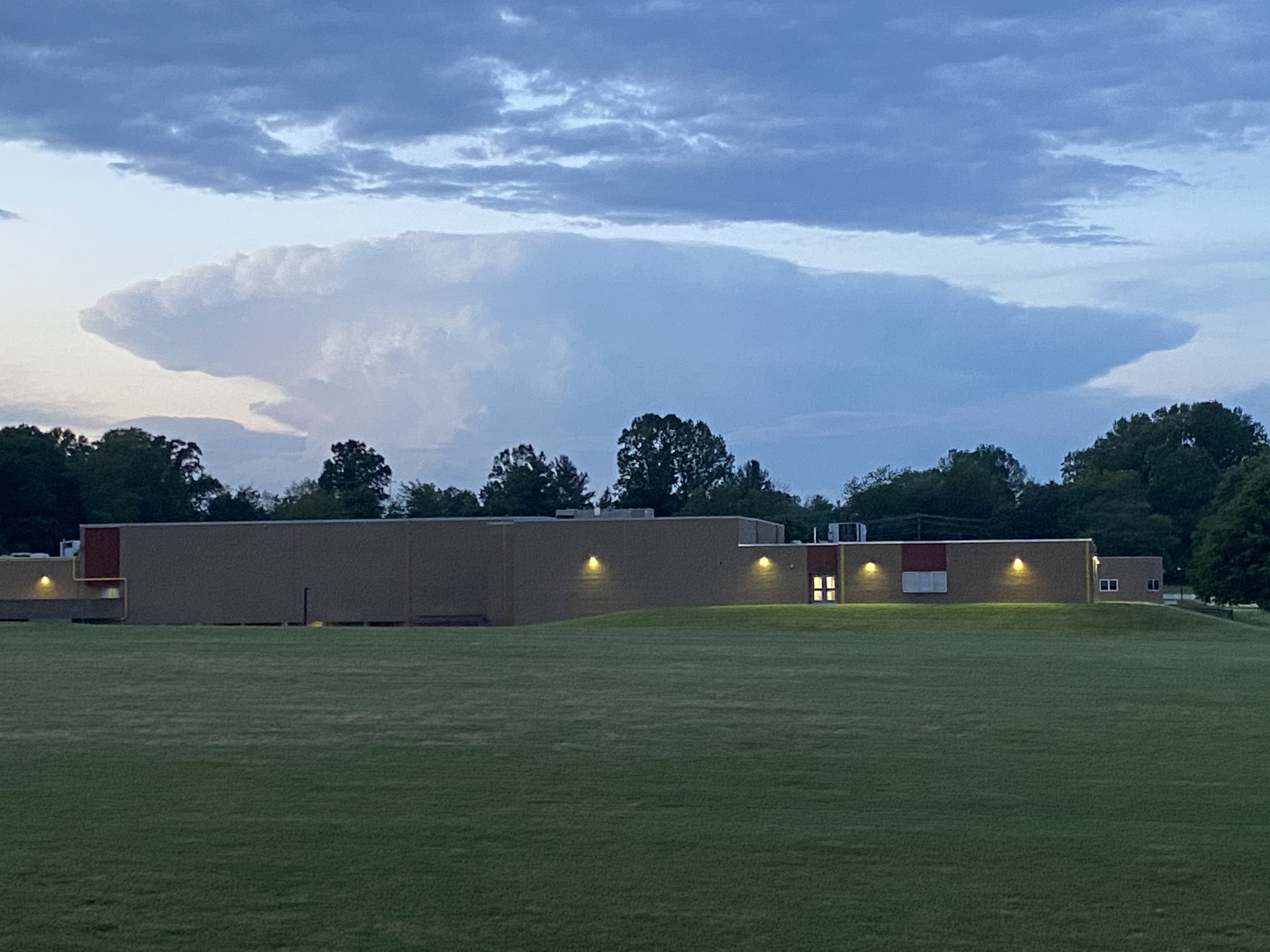
Had a glorious view of that York cell from southern Howard County. Could see a fair amount of lightning within it too.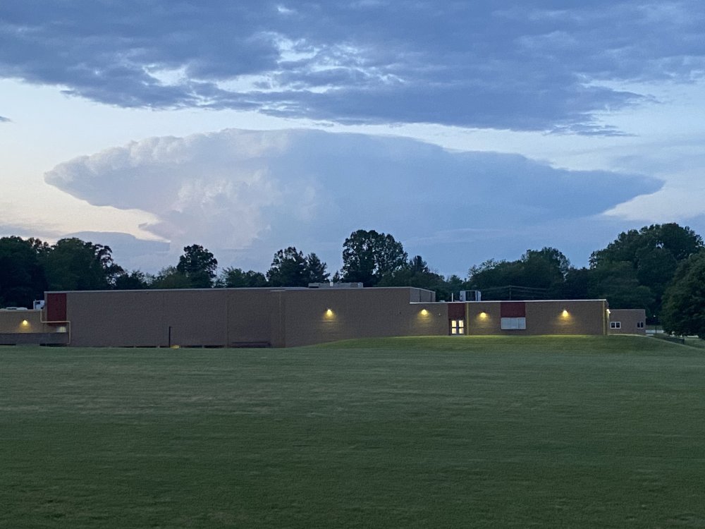
-
2020 Mid-Atlantic Severe Weather - General Thread
high risk replied to Kmlwx's topic in Mid Atlantic
yes, but there is still some organization and a clear sfc cold pool. Deep layer shear isn't quite as good as in some other CAMs, but the inverted-V sounding structure will definitely promote robust cold pool formation. I think we'll wake up tomorrow in a SLGT. -
2020 Mid-Atlantic Severe Weather - General Thread
high risk replied to Kmlwx's topic in Mid Atlantic
The next few hours are when a drop in dew points would occur if it does. The HRRR was most aggressive with that southwest of DC - will be worth watching. Still 65 here. Also, the day 2 kept MRGL here, but the discussion specifically mentioned a potential upgrade for our area in later outlooks. I personally think there was enough in the morning guidance to give us a day 2 SLGT, but I'll defer to the experts -
2020 Mid-Atlantic Severe Weather - General Thread
high risk replied to Kmlwx's topic in Mid Atlantic
Yes. The new MD mentions potential back building into north-central MD. Very little guidance has a good handle on the ongoing convection. -
2020 Mid-Atlantic Severe Weather - General Thread
high risk replied to Kmlwx's topic in Mid Atlantic
It's not going to be a huge day, but most of the various CAMs show about 40 kt of deep layer shear and inverted-V soundings, so some organization of cold pools is quite possible. The explicit reflectivity solutions across the hi-res windows, NAM nest, HRRR do show some organization. -
2020 Mid-Atlantic Severe Weather - General Thread
high risk replied to Kmlwx's topic in Mid Atlantic
Agreed. The 12z CAMs continue the idea of fairly good coverage of storms tomorrow. Deep layer shear isn't awesome, but it's probably enough for at least scattered SVR. The updated day 2 will maintain the MRGL for sure, and I wouldn't rule out a SLGT. -
2020 Mid-Atlantic Severe Weather - General Thread
high risk replied to Kmlwx's topic in Mid Atlantic
agreed. if something can race south earlier than progged, and the instability isn't killed by lowering dew points, northern and central MD could still be in the game. -
2020 Mid-Atlantic Severe Weather - General Thread
high risk replied to Kmlwx's topic in Mid Atlantic
We didn't have too many CAMs back then. The NAM nest was running, and it whiffed badly on that event. The HRRR did ok, but it was experimental, and not many people saw it. A key for today will be dew points. The HRRR is most aggressive in mixing them out (downsloping factor?). Most guidance mixes them out to some extent but try to have them recover closer to 00z, especially across northern MD. I certainly can't disagree with everyone ready to punt today, but I'm not ready to close the book quite yet, at least for those of us north of DC. -
2020 Mid-Atlantic Severe Weather - General Thread
high risk replied to Kmlwx's topic in Mid Atlantic
There will be some drying, due to what looks like modest downscoping, but the HRRR tends to overmix. I think that's why its dew points are a fair amount lower than most of the other guidance here tomorrow. -
2020 Mid-Atlantic Severe Weather - General Thread
high risk replied to Kmlwx's topic in Mid Atlantic
yes, but several other hi-res models look pretty good, especially for areas north of DC -
2020 Mid-Atlantic Severe Weather - General Thread
high risk replied to Kmlwx's topic in Mid Atlantic
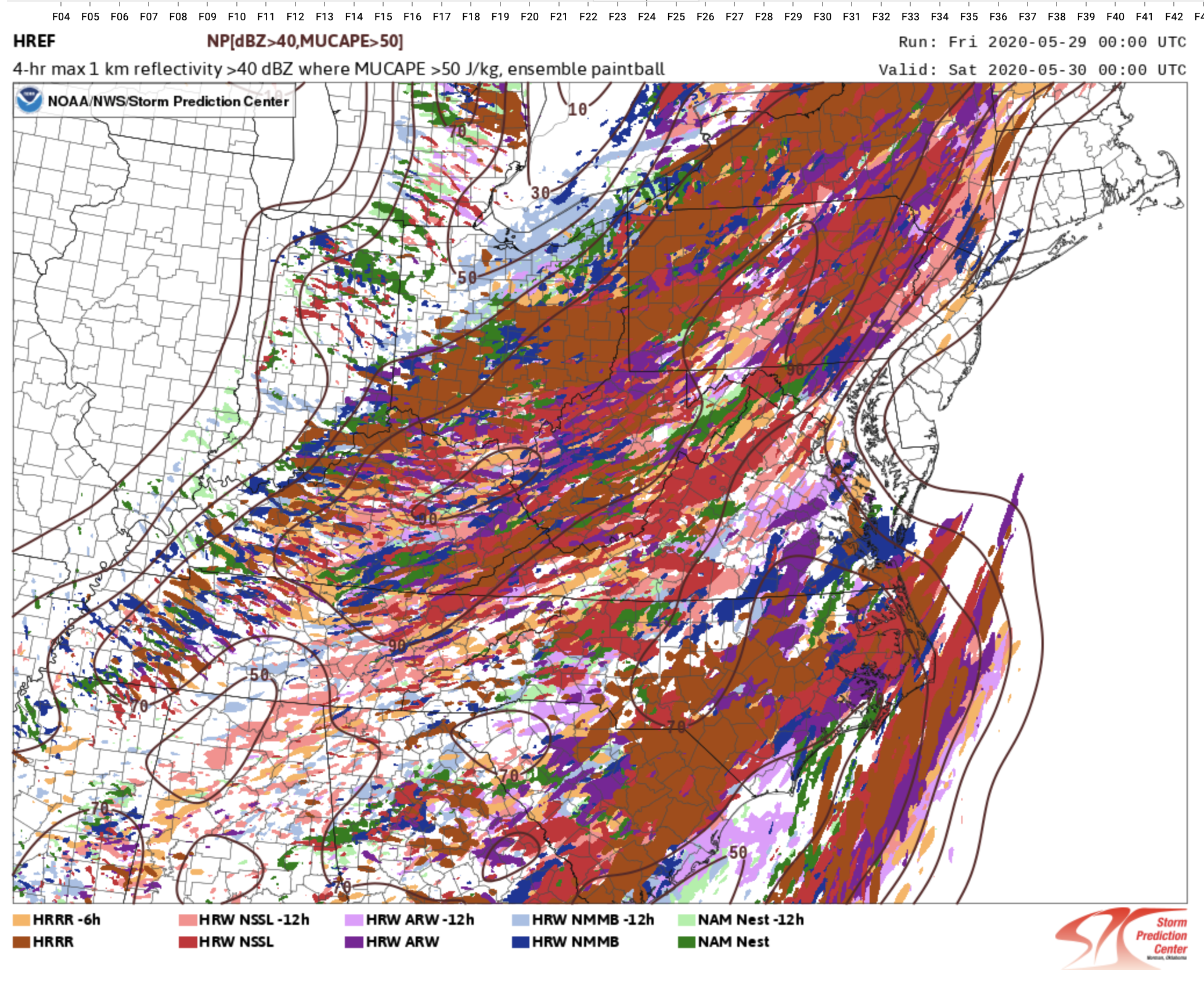
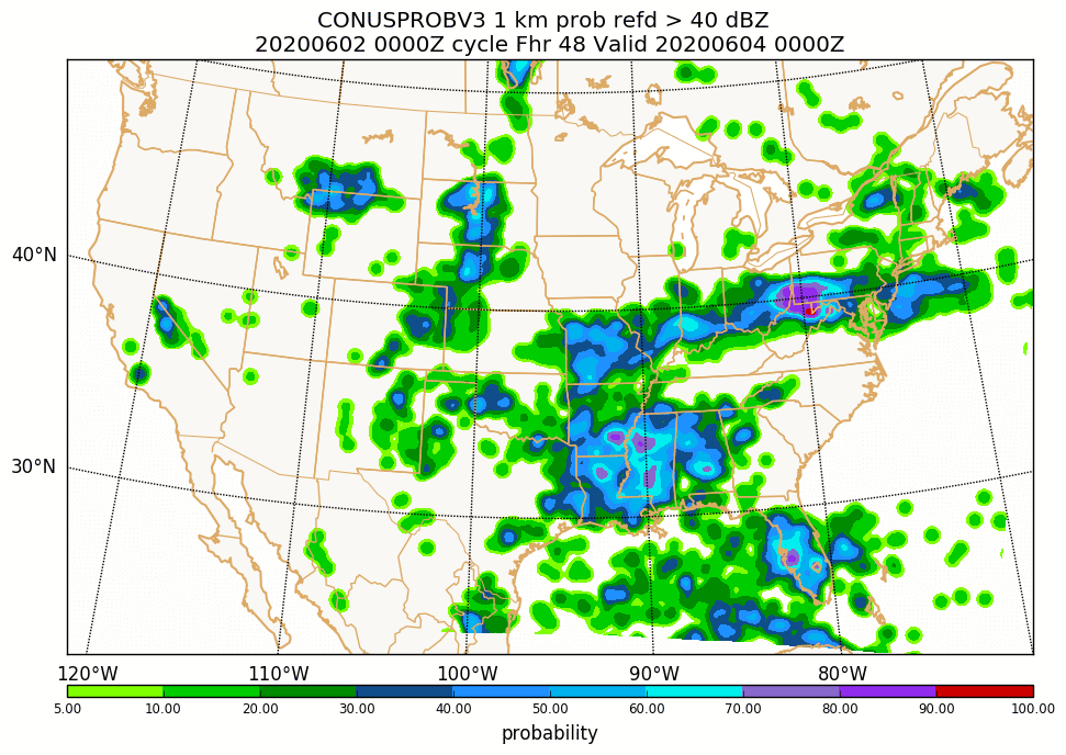
I actually thought that the overnight guidance took a nice step forward for tomorrow, with several CAMs bringing activity through the area either late Wednesday or Wednesday evening. It's reflected in the HREFv3 (updated version coming later this year with extension to 48h) that shows decent changes of 40 dbz at both 21 and 00z tomorrow: (to be clear, these aren't huge probs, but it's a step forward for sure)
-
2020 Mid-Atlantic Severe Weather - General Thread
high risk replied to Kmlwx's topic in Mid Atlantic
went back through the thread, and I'm officially issuing my mea culpa. -
2020 Mid-Atlantic Severe Weather - General Thread
high risk replied to Kmlwx's topic in Mid Atlantic
Soundings for Wednesday definitely look great. Shoutout to Kmlwx for noting this threat way in advance. While the dynamics as currently progged aren't great, a nearby front and small height falls could be enough. If we can trigger storms, the setup for SVR will be pretty robust. -
definitely weakening. The evening period was always our best shot (if you back in the SVR thread, the guidance was pretty clear about this) at storms, but it's arriving just too late, as nocturnal cooling has really kicked in.
-
2020 Mid-Atlantic Severe Weather - General Thread
high risk replied to Kmlwx's topic in Mid Atlantic
nice work, everyone! I remember that event quite well. I was warning people at work not to be on the roads at rush hour. That alert didn't work out too well...... -
2020 Mid-Atlantic Severe Weather - General Thread
high risk replied to Kmlwx's topic in Mid Atlantic
The EML is definitely essential here if we want a wind system to survive its trip over the mountains. In 2000, a bow echo was racing east towards us, and SPC put out the rare PDS severe thunderstorm watch, and it completely crapped out trying to cross the mountains of West Virginia and Virginia. We ended up with showers that gusted to 30 kt. -
2020 Mid-Atlantic Severe Weather - General Thread
high risk replied to Kmlwx's topic in Mid Atlantic
Blue box issued. Montgomery and Howard are in the far southeastern corner, consistent with the idea that this first show will mainly be a fair distance northwest of the I-95 corridor. -
2020 Mid-Atlantic Severe Weather - General Thread
high risk replied to Kmlwx's topic in Mid Atlantic
I'd say overall that southern PA has a slightly higher threat for SVR than the DC area, with a clear CAM consensus for a batch of storms to develop by mid afternoon over far eastern WV and northwest MD and track northeast towards the York and Harrisburg area. -
2020 Mid-Atlantic Severe Weather - General Thread
high risk replied to Kmlwx's topic in Mid Atlantic
https://www.spc.ncep.noaa.gov/exper/href/ (under forecast tools) and if you want information on the upcoming HREFv3 upgrade: https://www.emc.ncep.noaa.gov/users/meg/hrefv3/ -
2020 Mid-Atlantic Severe Weather - General Thread
high risk replied to Kmlwx's topic in Mid Atlantic
Still unsure whether storms will make it into the DC metro area. There is a better signal for storms moving northeast through northern MD, but anything in DC metro may be an iffy late evening show. It's reflected in last night's HREF members showing 40 dbz which show a clear minimum of members showing storms for DC and points east between 4 and 8pm. (Yes, the 6z NAM came in with a better solution, as shown in the previous post).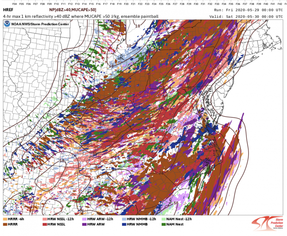
-
2020 Mid-Atlantic Severe Weather - General Thread
high risk replied to Kmlwx's topic in Mid Atlantic
The outlook is pretty legit, but as Amped noted above, the timing now definitely favors those west of the a line from Fredericksburg to Frederick. I'm not really seeing the tornado potential in the forecasted wind profiles, but there is definitely enough deep layer shear (accompanying the modest instability) for SVR. -
impressive tropical downpour here over southern Howard County just before 2pm