high risk
-
Posts
2,802 -
Joined
-
Last visited
Content Type
Profiles
Blogs
Forums
American Weather
Media Demo
Store
Gallery
Everything posted by high risk
-

2020 Mid-Atlantic Severe Weather - General Thread
high risk replied to Kmlwx's topic in Mid Atlantic
Nice research on this! 2008 was an active svr season for sure, but SPC was handing out MDT risks like Halloween candy. This was back before ENH existed, and they used MDT more liberally to try and distinguish from the run-of-the-mill SLGT days. In that respect, adding in the ENH was a very good move, as it allows them to represent those days with a larger coverage of lower end events and save the MDT for days with a decent concentration of higher end events. June 4, 2008 was a legit MDT for us, and it's a day I'll always remember. I guess that June 10 verified as a MDT over upstate New York and New England, although there weren't any high end reports; the MDT here didn't verify. May 31 and June 16 definitely would have worked fine with ENH, had that been an option. -
2020 Mid-Atlantic Severe Weather - General Thread
high risk replied to Kmlwx's topic in Mid Atlantic
hahaha! The bottom line is that with a big trough sitting to our west during a chunk of next week and moving towards the coast, there will be opportunities for severe in the east, with timing and other details obviously impossible to nail at long forecast lengths. -
2020 Mid-Atlantic Severe Weather - General Thread
high risk replied to Kmlwx's topic in Mid Atlantic
Interesting. Seems like the f144 would be the best shot at svr.... In terms of the progged 500 maps, you have to get excited when you see the day 5 maps showing an impressive trough to our west. The problem is that instead of it overspreading the mid-Atlantic, most guidance either lifts it to the northeast, weakens it, or both. As a result, the progged height falls over our area are really meh in the GFS, GEFS, and Euro ensemble. The deterministic Euro, though, is better and would imply svr chances here on day 6. -
2020 Mid-Atlantic Severe Weather - General Thread
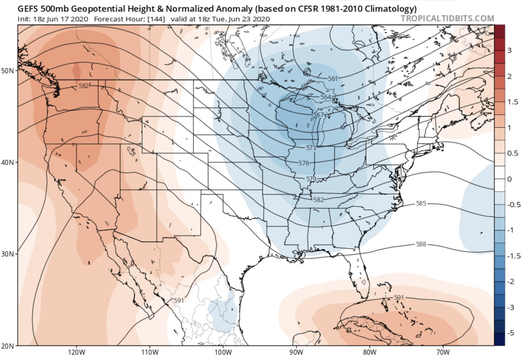
high risk replied to Kmlwx's topic in Mid Atlantic
Trying to make some sense of the CIPS lighting up. It's based off of the GEFS, and some of the recent GEFS means for next week look healthy. I grabbed the 18z (the analog was from the 00z cycle, but the 18z 500 map is arguably a bit better....). Anyhow, this is a great look at 500 mb, but of note, neither the Euro ops or ensemble looks anything close to this amplified.
-
2020 Mid-Atlantic Severe Weather - General Thread
high risk replied to Kmlwx's topic in Mid Atlantic
gotcha. and yeah, the 12z guidance seems to be moving the heaviest rain south - we'll see if that's a blip or a legit trend. Either way, the flooding threat will probably be there for some (i.e. lots of rain adding up over a multi-day period); whether it's a flash flood threat will depend upon whether we can get some clearing and heating near the upper low for convection. Right now, it just looks cloudy and cool. -
2020 Mid-Atlantic Severe Weather - General Thread
high risk replied to Kmlwx's topic in Mid Atlantic
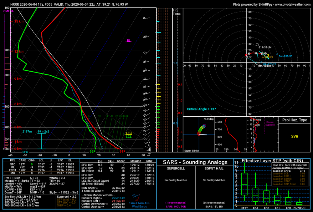
And I should note that part of this subforum is still in the game today, with cape and modest deep layer shear still in place. The CAMs show the threat as mostly DC and points south and east, but I still have a 71 dew point here in southern Howard County, so I'm not totally ready to write things off for those just north of DC either. -
2020 Mid-Atlantic Severe Weather - General Thread
high risk replied to Kmlwx's topic in Mid Atlantic
Since I assume you're referring to severe potential here in the severe thread, there's no severe potential this weekend or anywhere on the horizon. While there could be some convective elements in the Sunday-??? period within the rain, it looks like easterly flow over a deep layer and cool surface temperatures. -
2020 Mid-Atlantic Severe Weather - General Thread
high risk replied to Kmlwx's topic in Mid Atlantic
it's gone now, but it looked to me like there was weak rotation for a few scans -
2020 Mid-Atlantic Severe Weather - General Thread
high risk replied to Kmlwx's topic in Mid Atlantic
I think it's definitely a supercell or at least has supercellular characteristics. -
2020 Mid-Atlantic Severe Weather - General Thread
high risk replied to Kmlwx's topic in Mid Atlantic
definitely not done with storms for the evening and overnight. shear is marginal, but still some decent instability around. -
2020 Mid-Atlantic Severe Weather - General Thread
high risk replied to Kmlwx's topic in Mid Atlantic
yeah, it will be interesting to see whether it maintains this solution. The NAM nest has been semi-consistent with an evening threat a couple of hours earlier. The NSSL-WRF (ARW2) is the only model that has convection in the metro area before 00z. -
2020 Mid-Atlantic Severe Weather - General Thread
high risk replied to Kmlwx's topic in Mid Atlantic
A wind-driven MDT is certainly the type of event that might see the issuance of a PDS severe box. Curious to see how this plays out, with severe storms well-established already in western Michigan during the morning. The next box that gets issued out ahead of it might be PDS. -
2020 Mid-Atlantic Severe Weather - General Thread
high risk replied to Kmlwx's topic in Mid Atlantic
Thank you. I'm not aware of any correlation between the severe season and summer temperatures, but it's a great question. Some severe seasons are tempered by all of the flow being displaced north into Canada which usually implies a hot pattern. Some seasons like this one are tempered by anomalous blocking which kept a lot of people cool. And we all know that patterns can quickly break down. Looking at some of the longer range forecasts, they are showing a big ridge over the central U.S. and more troughing in the east (as you noted). This would imply fairly frequent frontal passages for us, with breaks in the heat, potential severe weather along the fronts, and maybe even some northwest flow severe events. -
2020 Mid-Atlantic Severe Weather - General Thread
high risk replied to Kmlwx's topic in Mid Atlantic
exactly. the entire SVR season has been ridiculously tame almost everywhere. there hasn't been a MDT for tornadoes since those April events in the southeast -
2020 Mid-Atlantic Severe Weather - General Thread
high risk replied to Kmlwx's topic in Mid Atlantic
Any threat in the DC-Baltimore area looks to be along and northwest of I-95 in Maryland, and the ARW2 and NAM nest are the models to hug. Haven't seen any HRRR runs get any convection of note into our region today, for what that's worth..... -
2020 Mid-Atlantic Severe Weather - General Thread
high risk replied to Kmlwx's topic in Mid Atlantic
The issue is that the best wind fields stay well west of here, which is why LWX talks about a threat west of the Blue Ridge That said, for those of further east, the wind fields aren't great but will be improving through Wednesday night. But the instability will be deceasing through that period, mitigating the threat of severe. There might be a period of overlap with decent shear and instability across northern VA early Wednesday evening. I am, however, thinking that people along and northwest of the I-95 corridor have a good chance of getting at least one round of northeast-moving heavy rainers with lightning later Wednesday evening. -
2020 Mid-Atlantic Severe Weather - General Thread
high risk replied to Kmlwx's topic in Mid Atlantic
Gonna bump my earlier post. Looking at the 00z guidance, there is a pretty healthy combination of cape and deep-layer shear progged for tomorrow afternoon. The limiting factor is downsloping and overall lack of convergence on the front, which explains the very limited coverage of storms in the guidance, but any storms that do form have wind potential (and perhaps hail potential) for sure. If later runs show greater storm coverage, it's a SLGT risk day. -
2020 Mid-Atlantic Severe Weather - General Thread
high risk replied to Kmlwx's topic in Mid Atlantic
We're obviously focused on the current day, but don't sleep on tomorrow. While the CAMs are not in agreement about whether there will be any storms, some guidance does (12z NAM nest, 18z HRRR....) bring fast-moving storms through on the front during the afternoon. Coverage would be limited, but the cape/shear combo is sufficient for a wind/hail threat in any storm that develops, consistent with the MRGL threat from SPC. -
2020 Mid-Atlantic Severe Weather - General Thread
high risk replied to Kmlwx's topic in Mid Atlantic
The HRRR Is better than you think. It's unfortunate that Tropical Tidbits shows only 1 km HRRR reflectivity, as the model rarely shows its best signals at that level. Pivotal Weather shows composite reflectivity, which always looks much better. (Composite will always be "hotter" than 1 km, but for the HRRR, it's usually a more realistic representation.) The composite reflectivity in recent runs suggests a lot of outflow interactions with potential for multiple rounds of storms well into the evening again. -
2020 Mid-Atlantic Severe Weather - General Thread
high risk replied to Kmlwx's topic in Mid Atlantic
I'm definitely down with the heavy rain threat later today. I'm not as excited about SVR potential (not that yesterday's SVR was off the charts, but the watch was a good one, IMHO) due to the shear being even weaker today, but the forecasted soundings still have a bit of an inverted-V structure, suggesting that a few local microbursts are possible. -
2020 Mid-Atlantic Severe Weather - General Thread
high risk replied to Kmlwx's topic in Mid Atlantic
-
2020 Mid-Atlantic Severe Weather - General Thread
high risk replied to Kmlwx's topic in Mid Atlantic
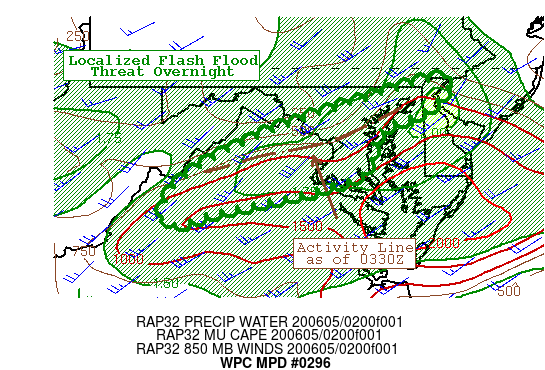
and now the flash flood watch has been issued. events like this show the huge challenges with hi-res, short-range modeling...... -
2020 Mid-Atlantic Severe Weather - General Thread
high risk replied to Kmlwx's topic in Mid Atlantic
getting drowned with this batch right now in southern Howard County with a lot of this batch still to move through. Watching the line along the I-81 corridor as well. Thinking that the recent dryness will prevent widespread flash flood potential but would not be surprised to see a FFW or two overnight. -
2020 Mid-Atlantic Severe Weather - General Thread
high risk replied to Kmlwx's topic in Mid Atlantic
This was always going to be a later event here, and that hasn't changed. Interesting now that the cell north of Harrisburg has a TOR warning, and the one near Gettysburg may have one soon. -
2020 Mid-Atlantic Severe Weather - General Thread
high risk replied to Kmlwx's topic in Mid Atlantic
for everyone talking this down, there is no doubt that if you require supercells or a big ugly bow echo (like in PA) yesterday to be validate a threat, it's not a day for that. but there will be convection moving through the area later (maybe most likely from DC and points north), and our forecast soundings have that inverted-V structure which favors a downburst threat (it's shown in the high downdraft cape values). Shear and instability are modest for sure, but the watch is totally justified, IMHO.