high risk
-
Posts
2,802 -
Joined
-
Last visited
Content Type
Profiles
Blogs
Forums
American Weather
Media Demo
Store
Gallery
Everything posted by high risk
-
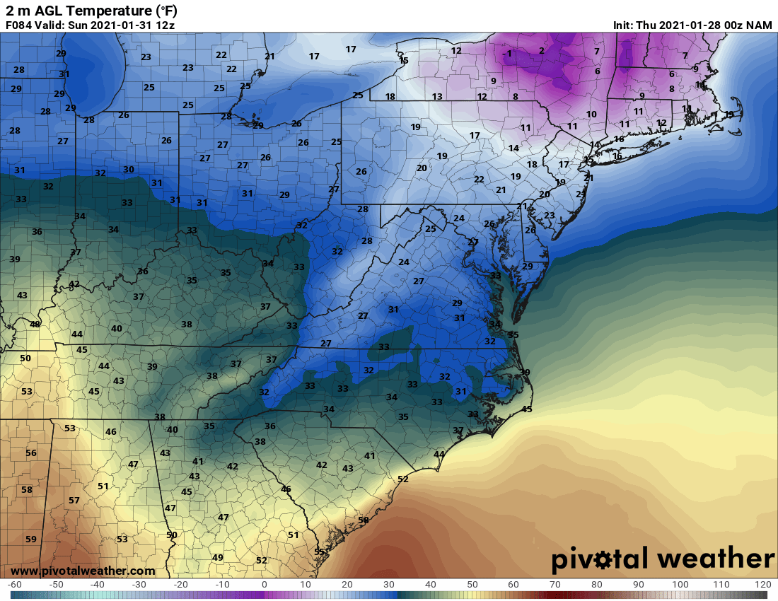
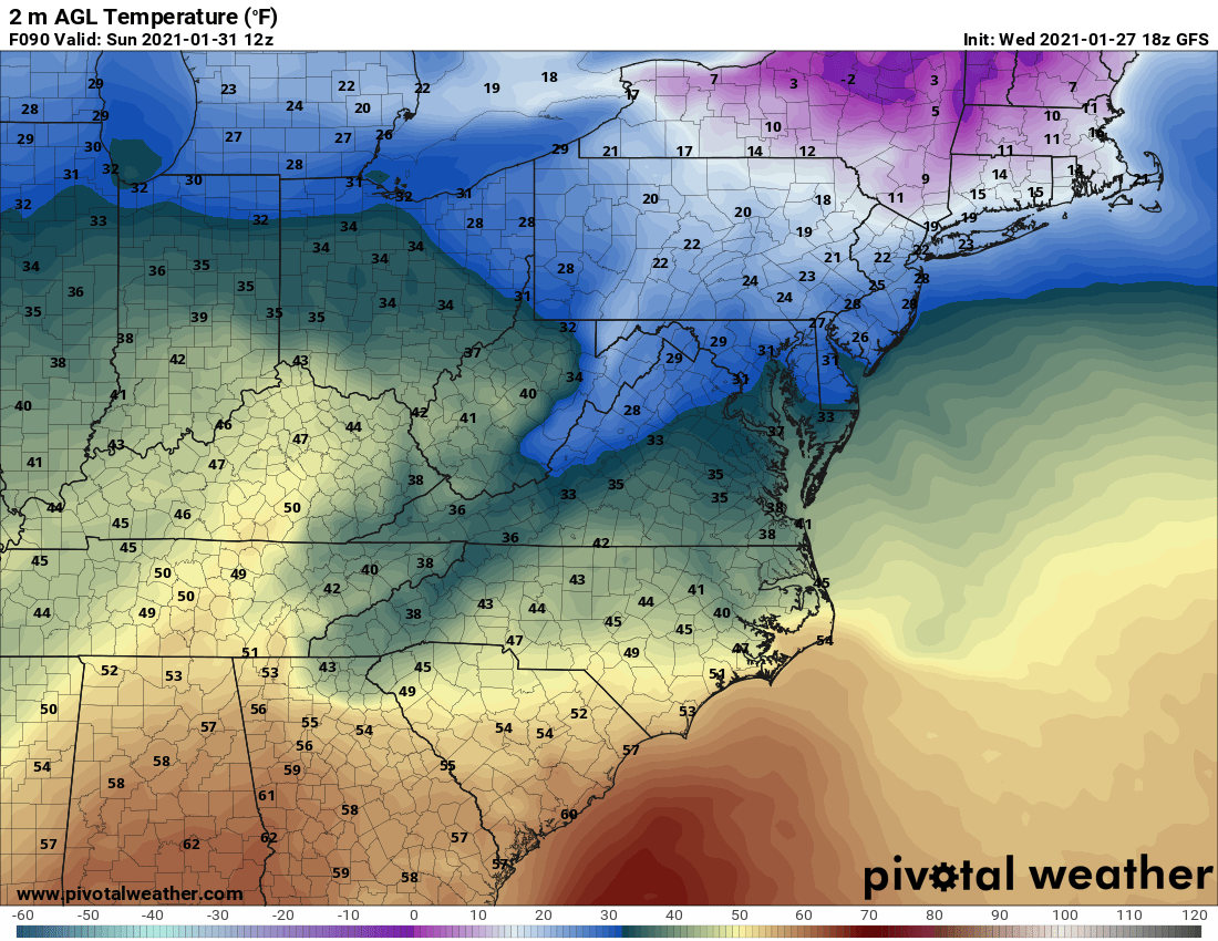
Look at how they handle the cold air damming over the Mid-Atlantic. The NAM consistently resolves this low-level cold air so much better than the GFS.


-
Very clear that the 00z NAM has a much stronger wave moving across the midwest than the 12/18z GFS did - looks much closer to the 12z Euro. It's also not as progressive as the GFS, but it's a little faster than the 12z Euro/Canadian.
-
yes, it accounts for the uncertainty in precip type in the transition zone
-
sh*t just got real.
-

January Storm Term Threat Discussions (Day 3 - Day 7)
high risk replied to WxUSAF's topic in Mid Atlantic
If we're going to parse ICON details, the 2m temps show that at some of what is being presented as "rain" would fall into a sub-freezing air mass, with the freezing line barely to DC by 09z Monday. -
January Storm Term Threat Discussions (Day 3 - Day 7)
high risk replied to WxUSAF's topic in Mid Atlantic
Some of us had two follow-up snowfalls. That Friday was another synoptic snowstorm, but there was a vort that Tuesday afternoon that put down a band of heavy snow across DC and the east side of town. I got another 6" out of that unexpected event. -
January Storm Term Threat Discussions (Day 3 - Day 7)
high risk replied to WxUSAF's topic in Mid Atlantic
All of the standard caveats apply (duh), but I find it very interesting that three different modeling systems (ECMWF, CMC, GFSv16) have now shown the idea of a capture and long-duration event for some part of the mid-Atlantic or northeast in at least one cycle. -
As bleak as the radar looks now, the models are pretty insistent that it will fill in again later this evening. I don't think that most of us will have the the thermals for snow by that point, but I'm at 29 right now, so sleet or freezing rain seems likely here in Howard County.
-
January Storm Term Threat Discussions (Day 3 - Day 7)
high risk replied to WxUSAF's topic in Mid Atlantic
You ain't kidding. Looks similar to the 12z CMC. -
Sleet here in southern Howard County. We knew from the forecast soundings that we had little margin for error with the profiles. Let's give this a little time to see whether rates can cool that pesky warm layer aloft just enough.
-
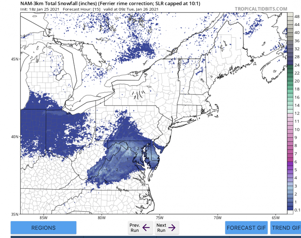
Very glad to see the dearth of 10:1 maps! Kuchera is a step up, but those will still be a bit generous in an event with such a sizable depth of the lower atmosphere with temps close to 0. It's also worth noting that the 18z NAM and NAM nest both cut down their QPF a bit, relative to 12z... I'm still going with the NAM nest as my model of choice here, and the Ferrier maps will best account for some accumulation being lost to riming with temps so close to 0 at several levels. DC people will be happy that it wants to whiten things there. For the rest of us north of DC, I think it's best to plan on 1-2 and hope that a few places overperform. Anyone expecting widespread 2-4 will likely be disappointed.
-
They're not, though. They have support with the HRRR and all 3 hi-res windows.
-
12z ops and para GFS have trended in a slightly snowier direction too.
-
I think they'll be making some changes in their next update....
-
Your thermal profile will certainly support snow, but you'll be fighting reduced QPF that far north. Some snow, though, seems quite likely.
-
To be clear, I'm saying to discount the heaver NAM12 QPF, and always discount the 10:1 maps in an event with marginal temperature profiles. But I would absolutely not discount the NAM nest, for which the reasonable snow products have 1-2" for areas north of DC (and maybe some snow inside the DC Beltway too for a little while). Look at the other CAMs rolling in this morning: the HRRR and all 3 hi-res windows have snow for a few hours at the start. The NAM idea is not an outlier.
-
Use the NAM nest, and use the snow depth or Ferrier product for an event like this. Shows the idea of a 1-2" event from northern Loudoun across Montgomery and Howard into Baltimore which matches the HRRR nicely.
-
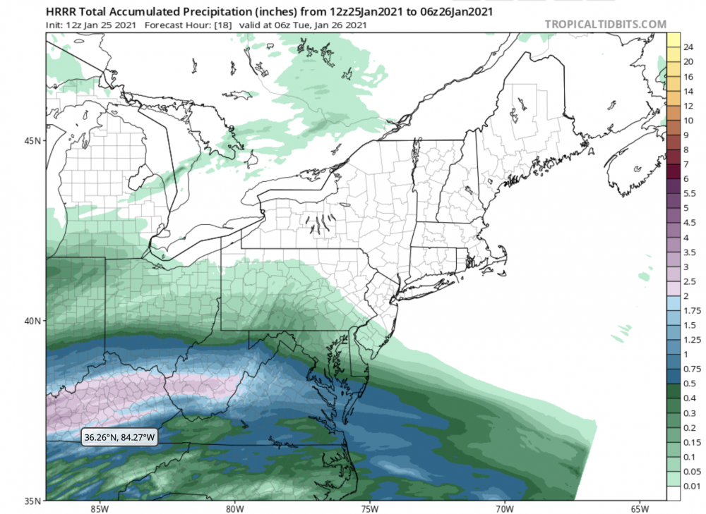
exactly. Here is the HRRR QPF during the time when it shows mostly snow for areas north of DC: And the vertical profiles show that temps are just barely cold enough aloft to stay as snow until you get further north in MD. Ugly tradeoff here: You need to go southwest to get higher QPF, but the better profiles will be further north. There *may* be a sweet spot somewhere in the middle (Howard-Montgomery deathband, anyone?) where they get into the slightly higher QPF and have a profile that just barely supports snow
-
January Storm Term Threat Discussions (Day 3 - Day 7)
high risk replied to WxUSAF's topic in Mid Atlantic
When an upgrade for any model is being prepared, the newer version has to be run in retrospective mode (to generate stats on performance for past years and to recalibrate historical guidance) and then in parallel mode. NCEP simply doesn't have the computer resources to run retrospectives and then a real-time parallel for both the GFS and GEFS at the same time. Ultimately, having the GFS and GEFS not be the exact same model is not ideal at all. Combining them into a single system will eliminate that flaw. -
January Storm Term Threat Discussions (Day 3 - Day 7)
high risk replied to WxUSAF's topic in Mid Atlantic
A single global ensemble system. In other words, we right now have a deterministic GFS that is run at a different resolution than its ensembles and can have a very different configuration. In ~2024, they'll be updated together. There will still effectively be a "GFS", but it will be control member of the ensemble. -
January Storm Term Threat Discussions (Day 3 - Day 7)
high risk replied to WxUSAF's topic in Mid Atlantic
Yes, the GEFS will not be updated when GFSv16 is implemented. The good news is that the GFS and GEFS will be merged into a single system in 2024. -
January Storm Term Threat Discussions (Day 3 - Day 7)
high risk replied to WxUSAF's topic in Mid Atlantic
probably sometime in March now. -
Fair point. I think I'm at close to my breaking point because of Weather53's crusade against NWP.... Honestly yes. The NAM is colder than the GFS which is notoriously crappy with low-level temperature profiles, and the NAM (in conjunction with the HRRR and some other meso models) is telling me that if I'm north of the Beltway tomorrow evening, I have a decent shot to see a modest accumulation of snow. I personally rarely look at the 12 km version of the NAM, because the NAM nest is a much better model, and I think that is a good strategy here this evening with the 00z cycle.
-
Ok, that was my snarky answer. The better answer builds on that a little more. It's still one of the best models for handling shallow cold air masses and things like terrain-induced wind storms in the west and fog. Ultimately, the NAM nest is a way better model, but it's driven by the 12 km NAM, so that's another reason to keep running it. Ultimately, the NAM nest and parent are frozen (no more development is being done on them) and will likely be retired in ~3 years.
-
Because there is way more to judge it by than whether it's too cold and wet for DC area mixed precip events.