high risk
-
Posts
2,802 -
Joined
-
Last visited
Content Type
Profiles
Blogs
Forums
American Weather
Media Demo
Store
Gallery
Everything posted by high risk
-

2021 Mid-Atlantic Severe Weather - General Discussion
high risk replied to Kmlwx's topic in Mid Atlantic
It's possible, but the threat would be after dark this evening, and most sfc-based instability should be gone by then. -
2021 Mid-Atlantic Severe Weather - General Discussion
high risk replied to Kmlwx's topic in Mid Atlantic
That was a nice start to the convective season this afternoon. As for Sunday, my guess is that we wake up in the morning to a Day 2 MRGL. Seems quite likely that there will be some storms around later in the day (especially north of DC), and parameters aren't great, there is probably just enough low-level and deep-layer shear to get some decent wind gusts and hail. This will become a more robust threat if the higher NAM dew points (low 60s) are attained. -
c'mon over to the April obs thread.
-
moderate graupel shower here in southern Howard County
-
I actually wouldn't totally rule out snowflakes in some of the heaviest cores.
-
The freezing levels are really low, so I'm pretty sure that any heavier cores like that would put down some hail or graupel here in the metro areas.
-
One potential bit of sneakiness for tomorrow: while most guidance seems to have backed off on the chances of the early morning precip ending as a period of wet snow (although it still seems like a few mangled flakes are possible north and northwest of DC), they are more bullish on the idea of some showers in the afternoon as the upper trough axis swings through, especially on the west side of DC. If you squint at the P-type maps, you can see a little blue in the heavier cores, and the forecast soundings have very low freezing levels and a little bit of instability. I would not be surprised to see some heavier graupel (or even briefly wet snow) showers around.
-
maybe 50s Saturday and near 70 Sunday? 850 temps still look pretty low on Saturday......
-
2021 Mid-Atlantic Severe Weather - General Discussion
high risk replied to Kmlwx's topic in Mid Atlantic
500 j/kg of CAPE will do that.... -
2021 Mid-Atlantic Severe Weather - General Discussion
high risk replied to Kmlwx's topic in Mid Atlantic
Back in town now, and while this is nowhere as good of a setup as it looked like it might be a couple of days ago, it's not dead. The instability is of course the big question, but with strong forcing on the front and pretty good shear, there will likely be a line of convection ahead of the front. (It is clearly getting organized now). If we get up near 70 over the next few hours, there is probably some wind damage potential. The better chances are certainly further south, but I'm not totally writing it off north of town. -
2021 Mid-Atlantic Severe Weather - General Discussion
high risk replied to Kmlwx's topic in Mid Atlantic
I fully agree. The shear on all guidance is incredibly impressive - I'm even seeing big, looping hodographs and PDS TOR on some forecast soundings. Still some questions about instability: the parent NAM by far looks the best. GFS keeps showers and clouds around for much of the day, limiting heating. NAM nest seems to mix out the low level moisture a bit during the afternoon, although even that model has an impressive QLCS approaching late in the day. -
2021 Mid-Atlantic Severe Weather - General Discussion
high risk replied to Kmlwx's topic in Mid Atlantic
I'm totally out on this one. Honestly, I'm not sure that discussion makes sense unless they're talking about the very southern part of the CWA. We do not get anything close to SVR here from elevated storms above a stable boundary layer. I'll consider it a big win if I hear thunder Thursday evening. -
It's my day!!! I'm humbled, but I can't help but think that a high-end MDT would have worked fine for today..... In other news, this may have been covered elsewhere, but the NCEP "critical weather day" means that GFSv16 can't be implemented today (or tomorrow with the MDT). As a result, it has to wait until next Monday.
-
We’re getting close, but implementation is actually on Wednesday morning.
-
all 3 major airports already getting close to 70!
-
big flakes mixing in here in southern Howard County
-
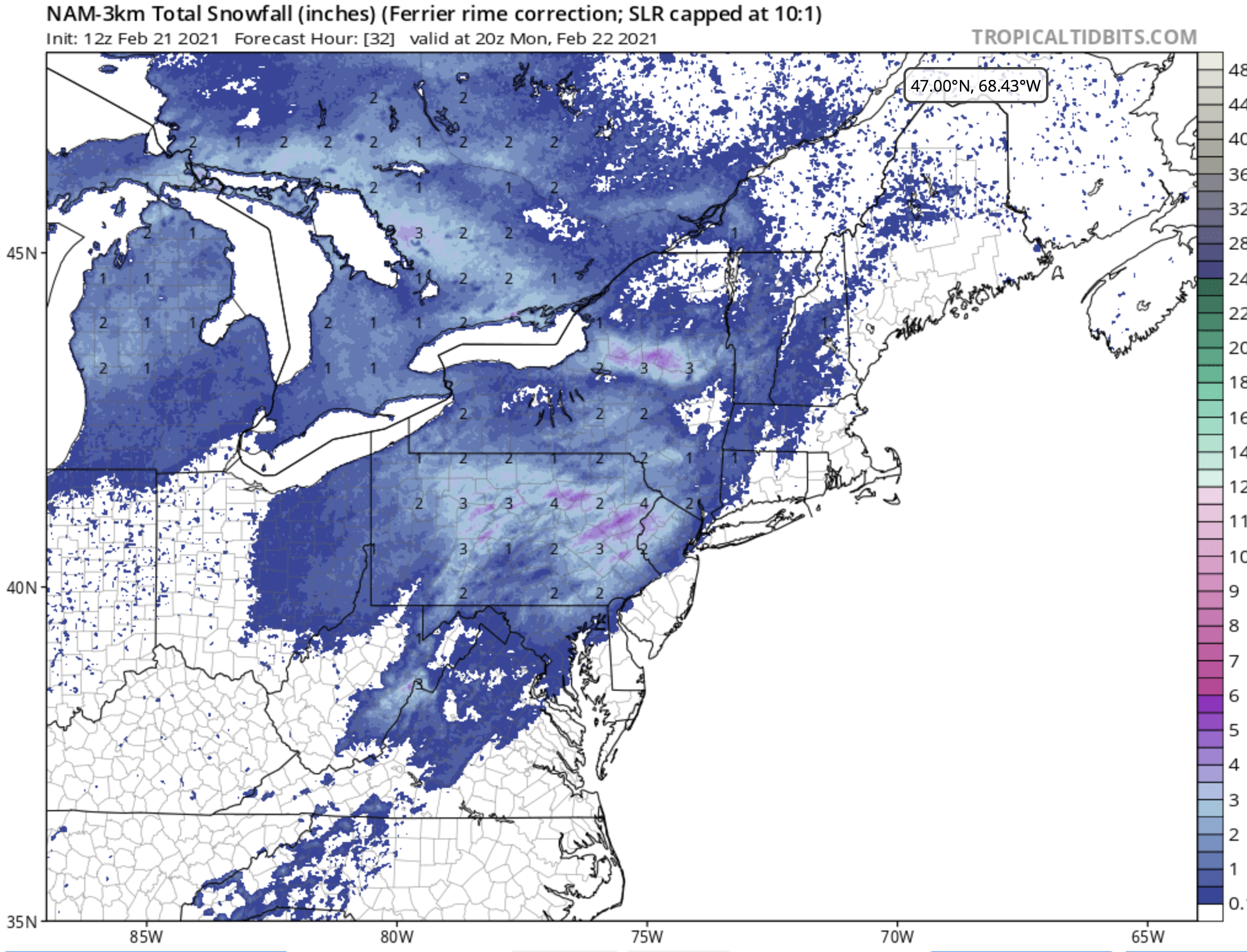
This product from the NAM nest (based off what the model microphysics thinks about how "pure" the snow is as it reaches the surface) has worked really well in some recent events, and it looks pretty reasonable to me for tomorrow (1-2 inches in northern MD). IF the NAM nest is too slow with the arrival of the precip (a common bias, but a lot of the other guidance doesn't look *too* much faster), then we can potentially take more advantage of the colder profiles in place at the start of the morning.

-
@MillvilleWx likely has a way better feel for this than I do, but the largest drift is going to be at the upper levels where the winds are stronger, and some drift has already taken place during the ascent. The amount of drift by the time the sonde reaches 850 is much less.
-
It absolutely accounts for balloon drift. The GPS sensors in the sonde relay lat/lon info at each level, and the data is assimilated at the actual location.
-
two things to note from the 6z NAM nest: 1) it still has the heaviest precip falling during the mid to late morning hours. It's not going to be a snowfest, and we all thought that the precip shield would come in with a much greater thump, but the current scattered nature of the steadier precip doesn't warrant all of the 'busted QPF' calls. 2) it now has a period of (modestly) accumulating snow for a lot of us Friday morning
-
If we're going to post the HRRR maps every hour, please use the Pivotal Weather Total Accumulated Snowfall (not the 10:1 or the Kuchera). This is the true snow output from the model with an SLR that it computes based on low-level temps. You'll see clear differences between it and the other two.
-
the GFS has a remarkable amount of precip fall after 18z tomorrow along and east of I-95 (including a crazy amount of ice), but it's alone on an island. The NAM is at the other end of the extremes with perhaps the GFS para offering a more realistic middle ground (and more of a light sleet to light snow for most of us scenario, instead of freezing rain)
-
I've learned to not ebb and flow too much with the hourly HRRR runs in winter precip. There always seems to be lots of run-to-run fluctuation with precip amounts.
-
Besides the NAM nest (and the parent NAM, but I'm focusing on hi-res), the HiResW ARW and ARW2 this evening both also favor the earlier transition to sleet. The HRRR and the HiResW NMMB are both snowier, but they both tend to be too snowy in these setups. I won't abandon hope since the forecasted soundings are walking such a tightrope with the warm layers, but I don't like what I've seen so far from the 00z suite for a healthy snow accumulation in most of the area.
-
I remember that storm really well. That was an incredible thump - the precip arrived like a wall of white.