high risk
-
Posts
2,803 -
Joined
-
Last visited
Content Type
Profiles
Blogs
Forums
American Weather
Media Demo
Store
Gallery
Everything posted by high risk
-

Feb 24-25, 2022 Ice/Sleet/Rain/Snow (yeah sure) Storm Thread
high risk replied to WinterWxLuvr's topic in Mid Atlantic
I'm calling complete and total b.s. here. There isn't a model that gets 40 degrees to DC or even close by midnight tomorrow night, much less mid to upper 40s. This isn't some 995 sfc low blasting by to our northwest; it's a weak surface system with an accompanying weak pressure gradient, and the cold wedge will take time to erode. -
Feb 24-25, 2022 Ice/Sleet/Rain/Snow (yeah sure) Storm Thread
high risk replied to WinterWxLuvr's topic in Mid Atlantic
Surface temps around the metro area tomorrow evening, and the precip totals won't be huge, but there is a pretty clear signal for a period of sleet or freezing rain for a lot of us. Even if sfc temps warm up above freezing, there is a still a cold layer immediately above in pretty much all guidance for at least a few hours. -
Feb 24-25, 2022 Ice/Sleet/Rain/Snow (yeah sure) Storm Thread
high risk replied to WinterWxLuvr's topic in Mid Atlantic
I don't know for sure, but I think that they're at least using the precip type information directly from the models and not computing it themselves. Regardless, it's applying an instantaneous precip type to an accumulated precip. -
Feb 24-25, 2022 Ice/Sleet/Rain/Snow (yeah sure) Storm Thread
high risk replied to WinterWxLuvr's topic in Mid Atlantic
Right! It's most pronounced for the NAM beyond 48 hours or the GFS beyond day 5, as those models have hourly output through those times, although that assumes that the various sites are actually pulling in the hourly data. The bottom line, though, is that it definitely inflates freezing rain and sleet totals. -
Feb 24-25, 2022 Ice/Sleet/Rain/Snow (yeah sure) Storm Thread
high risk replied to WinterWxLuvr's topic in Mid Atlantic
This is a fair point. None of these accumulation computations is making any attempt to determine how efficiently the ice can accrete. They're just looking for freezing rain as the precip type at the top of the hour, and if that is found, all of the QPF from the past hour (or in some cases, 3 or 6 hours!) goes into the freezing rain bucket. In fact, only the RAP/HRRR actually have a true tallies of freezing rain and sleet. -
Feb 24-25, 2022 Ice/Sleet/Rain/Snow (yeah sure) Storm Thread
high risk replied to WinterWxLuvr's topic in Mid Atlantic
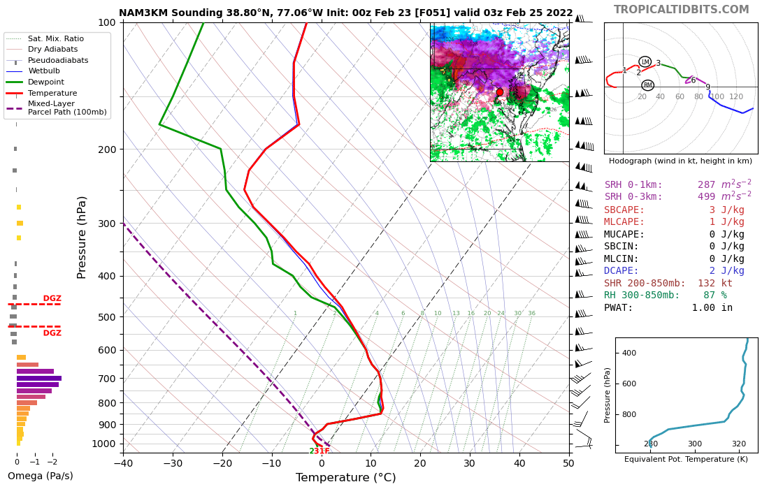
I think I'm buying on sleet and freezing rain for at least a while in much of the area. Even if the sfc temps are too cold in the NAMs (and I'm not convinced that they are), it's pretty clear that there will be a fairly deep layer below freezing just above. Shows up really well on the NAM Nest: Even the GFS has the same idea - the cold layer isn't as cold or as deep, but it's there. The winds in that cold layer are southeast, so it won't be able to hold in for the whole night (until you get further north), but I think that the idea of a cold layer near the ground during the late afternoon and evening could very well be correct. The biggest wild card is actual precip, as there is still limited agreement on the QPF details.
-
A number of the CAMs either explicitly show a similar feature or hint at it. The Saturday front is really strong, and the environment ahead of it will have healthy lapse rates, so I think that the chance of a forced line of convection along the boundary is fairly high. Temperatures would support rain showers quickly changing to snow.
-
2022 Mid-Atlantic Severe Wx Thread (General Discussion Etc)
high risk replied to Kmlwx's topic in Mid Atlantic
So nice to see this thread! Cheers to a great 2022 severe season! That said, I'm not very excited about later tonight. Temperatures should stay up overnight, but we need every degree we can get, and having the threat in the afternoon would have helped. The shear is awesome, but the lapse rates suck, and there just isn't much chance of getting even a few hundred joules of cape. There will be convective enhancement of the rain early Friday, but it seems like the SVR threat is really, really low. -
Feb 12/13 Event Quest for Blues to Envelop More Rather Than Less
high risk replied to North Balti Zen's topic in Mid Atlantic
Some reasonable agreement between the 18Z NAM Nest and GFS - my confidence level always goes up with they align. -
The precip shield is pretty clearly going to extend further to the northwest than initially thought. The problem for weenies, however, is that even with "close" sfc temps, the forecasted soundings overall don't seem to support snow on the northwest edge. That said, some of the temperature profiles wouldn't require too much cooling to become wet snow, so I suppose that a few surprises are possible.
-
I can't argue with this thinking, and it seems like the 18Z NAM is moving towards that idea.
-
The 18Z HRRR laughs at our thread
-
FWIW, and I say this with every caveat about no two events being the same, the ARW and ARW2 Hi-Res Windows were the coldest (and most erroneously cold) models for the January 20 rush hour bust. The GFS and Hi-Res Window FV3 were the next coldest. NAM and NAM Nest were next "best" but still a bit cold. The Canadian models did the best. Again, it was a single case, but it did involve shallow cold air spilling into the area.
-
Late January and February Medium/Long Range Discussion
high risk replied to WinterWxLuvr's topic in Mid Atlantic
Oh, F*ck yes!- 4,130 replies
-
- 13
-

-
- prime climo
- cold canada
- (and 1 more)
-
Late January and February Medium/Long Range Discussion
high risk replied to WinterWxLuvr's topic in Mid Atlantic
Way more SREF information than anyone ever wanted or needed, but in addition to initial condition differences, the members are comprised of two different cores, and there are some other physics differences too. And one of those model cores is a system that has mostly been retired, so as noted, it's very much an outdated system.- 4,130 replies
-
- 4
-

-

-
- prime climo
- cold canada
- (and 1 more)
-
Late January and February Medium/Long Range Discussion
high risk replied to WinterWxLuvr's topic in Mid Atlantic
I'm really surprised by what I've seen from the guidance so far today, as while the GFS is documented to do a poor job with shallow cold air masses, it's usually *slow* to bring them in. Seeing the GFS be faster than other guidance with the arrival of the cold into our area is not what I expected to see. The bottom line is that I need to see another model show the same idea before I'm going to get anything close to being on board.- 4,130 replies
-
- 18
-
-
- prime climo
- cold canada
- (and 1 more)
-
January 28-29 2022 Miller abcdefu Storm Obs/Discussion
high risk replied to mappy's topic in Mid Atlantic
I lean towards lower totals in the jackpot zone too, but as some of the cooler heads (or major weenies) have noted in that discussion, there was a storm in 2015 (I think) where the models kept the huge snows out of southeast New England despite an amazing look at h5, and they ended up getting crushed. -
January 28-29 2022 Miller abcdefu Storm Obs/Discussion
high risk replied to mappy's topic in Mid Atlantic
H5 looks super, but several models show a bit of a strung-out mess at the surface. The New England forum is freaking out. -
edit: and "looks great" should have been "looks improved with the front end snow" and of course, the Nest doesn't look as good.
-
NAM parent looks great with the snow, but temps are above freezing until early evening, so it might struggle to accumulate during the daylight hours.
-
As we try to sort through all of the disagreement between the models, one thing that stands out to me is how much the GFS and NAM Nest agree on the precip field. I have no idea how this is going to play out, when the NAM and GFS disagree, but the NAM Nest is close to the GFS, I take notice.
-
or not.....
-
18Z GFS looks much different than the 18Z NAM that had us throwing ourselves over the cliff last hour. Stronger, more phased wave and higher heights out front. Not saying that this will put the coastal low in a favorable spot for us, but it should hopefully retain our Friday evening/night snow here.
-
Perhaps, but guidance has us getting to the upper 30s during Friday and only falling back to around freezing for the evening rush. Moderate snow at rush hour will have some impact for sure, but that's not the standard recipe for rush hour disaster here.
-
Thursday 1/20/22 Stat Padder Discussion and Observations
high risk replied to stormtracker's topic in Mid Atlantic
I'm thoroughly confused, as Pivotal 10:1 has almost 3" on the ground around DCA by 12Z, while TT 10:1 has a small fraction of that. The final totals then of course end up with a big discrepancy. There is a single snowfall field in the GFS (it's a liquid equivalent), so they should in theory be using the same field, applying the same 10:1 SLR, and getting the same result. One of them is doing something funky, and my money is on Pivotal being the goofball.