high risk
-
Posts
2,802 -
Joined
-
Last visited
Content Type
Profiles
Blogs
Forums
American Weather
Media Demo
Store
Gallery
Everything posted by high risk
-
Time to update the max temps for today. Temps soaring ahead of the front.
-
Ah, that makes sense - I misinterpreted. As I mentioned in the SVR thread, I thought that a SLGT was possible, but the MRGL may work ok. I do expect several warnings and a handful of wind reports (and an outside chance of a brief TOR).
-
Is there a box out?? I haven't seen one....
-

2022 Mid-Atlantic Severe Wx Thread (General Discussion Etc)
high risk replied to Kmlwx's topic in Mid Atlantic
Hodographs definitely support supercells, although low-level shear *appears* to be insufficient to actually get rotation to the ground. -
2022 Mid-Atlantic Severe Wx Thread (General Discussion Etc)
high risk replied to Kmlwx's topic in Mid Atlantic
No doubt that we could certainly get a low-topped event in the next 2 months, but for now, today's storms seem to have initiated ahead of schedule. NAM Nest is further south, but the HRRR has been pretty consistent with the greatest coverage around DC and points north. -
2022 Mid-Atlantic Severe Wx Thread (General Discussion Etc)
high risk replied to Kmlwx's topic in Mid Atlantic
Last hurrah for this thread?? Pretty clear in the CAMs that strong convection will form later Monday afternoon, but there is disagreement on location, timing, and coverage. Regardless, shear will be more than adequate, and instability overall looks to be sufficient (and somewhat impressive on the latest NAM Nest and HRRR runs). The MRGL is certainly warranted (as is the 2% TOR, although low-level shear might be too weak), and I would not be surprised if this ends up as a SLGT. -
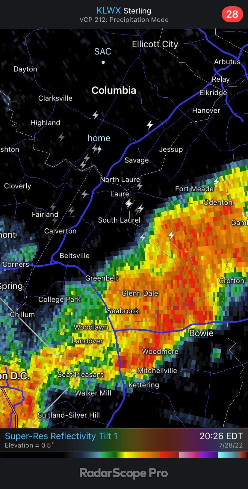
already up to 1.1" in southern Howard County at 10:30 AM
-
Flooding a likely concern on Sunday:
-
Got close to 0.6" in the heavy showers that rolled through Howard County at dinner time. Some very solid model consensus for a more widespread area of heavy rain for the early morning hours into rush hour.
-
2022 Mid-Atlantic Severe Wx Thread (General Discussion Etc)
high risk replied to Kmlwx's topic in Mid Atlantic
The 12Z guidance went back to having several CAMs ripping the line to shreds as it arrives. -
2022 Mid-Atlantic Severe Wx Thread (General Discussion Etc)
high risk replied to Kmlwx's topic in Mid Atlantic
I want to be intrigued by tomorrow, but at this point, I'm just hoping for rain. The shear is very marginal, but it looks like there will be some modest instability and a decent amount of downdraft cape. The simulated reflectivity forecasts are all over the place, but there may be some agreement on a weakening line approaching the metro areas by early evening, possibly intensifying a bit over the eastern burbs. -
LWX ignored some decent signals in the CAMs for convection today......
-
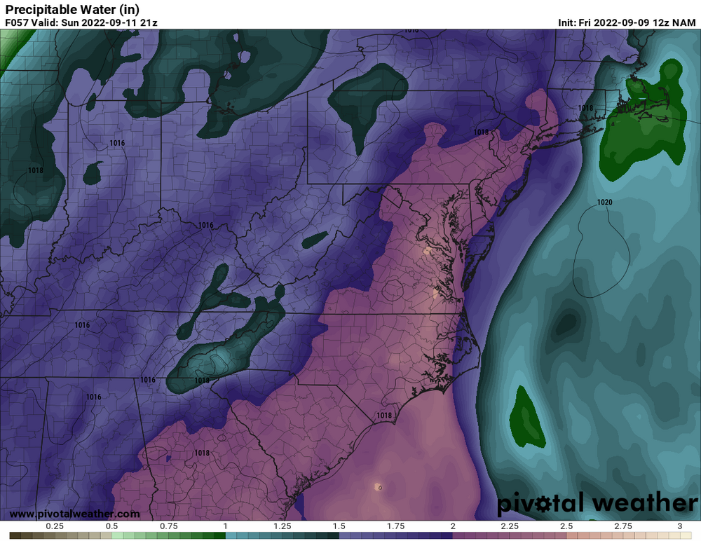
Right. Instability is important, but Precipitable Water is a better driver of flooding rains than CAPE.
-
several CAMs fire storms along the sea breeze in Delaware by early/mid afternoon
-
2022 Mid-Atlantic Severe Wx Thread (General Discussion Etc)
high risk replied to Kmlwx's topic in Mid Atlantic
There were several lightning strikes this evening on outflow boundaries, with no rainfall or other nearby lightning, so it's not surprising that people were caught off guard. -
NAM Nest is doing its usual thing of having low-level dew points that are too high, which inflates the CAPE. That said, even though that solution has the most organized convection of the CAMs, most do show at least a few storms in the area later today. Tomorrow looks like the bigger deal. The HRRR is an outlier with its *low* dew points - most CAMs show widespread heavy storms in the area towards dinner time.
-
some significant changes so far in the 12Z suite of models: several CAMs now show a batch of heavy showers moving across a good chunk of northern VA and northwestern MD during Sunday afternoon. The HRRR even goes so far as to make it a full Sunday afternoon washout for the metro areas. Will be interesting to see if this is a one-cycle glitch for the guidance or if it's figuring out now that Sunday won't be nearly as nice of a day as originally expected.
-
2022 Mid-Atlantic Severe Wx Thread (General Discussion Etc)
high risk replied to Kmlwx's topic in Mid Atlantic
Got 0.26" just south of you. I posted in the Obs thread that the thunder really started cranking after the line passed, and you could see it in the lightning data. There were many strikes well behind the rainfall, including one here that was maybe 75 yards away and took out our power for 5 hours -
2022 Mid-Atlantic Severe Wx Thread (General Discussion Etc)
high risk replied to Kmlwx's topic in Mid Atlantic
Slight risk today includes DC at the northern edge. Consistent with that, HRRR definitely likes the area south of town. -
This is an excellent discussion. The GFS hasn't caught on to this threat yet, but the ECMWF and Canadian have.
-
One other odd aspect of the storm yesterday: there was no lightning as the line moved through southern Howard, but it started cranking out bolts on the back side of the storm as it moved into PG. There were numerous lightning strikes in Howard, eastern Montgomery, and western PG well after the rain had ended, including one that was way, way too close here and knocked out our power for 5 hours.

-
2022 Mid-Atlantic Severe Wx Thread (General Discussion Etc)
high risk replied to Kmlwx's topic in Mid Atlantic
Today was a total kick in the teeth. -
2022 Mid-Atlantic Severe Wx Thread (General Discussion Etc)
high risk replied to Kmlwx's topic in Mid Atlantic
Good point, but I *think* that it only affects the timing and not whether we get storms. If the line remains intact, I think it drives through the area in the early afternoon. If not, we wait for cells to fire to our west and move east during the later afternoon. None of the CAMs fail to move storms through the area at some point today, although there are admittedly disagreements in the amount of coverage. -
2022 Mid-Atlantic Severe Wx Thread (General Discussion Etc)
high risk replied to Kmlwx's topic in Mid Atlantic
I feel even better after looking at the 00Z suite, especially for those south of I-70. -
2022 Mid-Atlantic Severe Wx Thread (General Discussion Etc)
high risk replied to Kmlwx's topic in Mid Atlantic
Right, and we have respectable shear too. My concern remains, however, that several CAMs have a dying line arriving during the morning. Most of the solutions still allow us to get hot and generate new strong storms on the outflow, but the coverage isn't what I would expect to see in the setup, and we all know that this type of scenario fails here with great ease. I'm still optimistic (honestly, I just want some rain!), but it's a cautious optimism.