high risk
-
Posts
2,802 -
Joined
-
Last visited
Content Type
Profiles
Blogs
Forums
American Weather
Media Demo
Store
Gallery
Everything posted by high risk
-
Simulated radars today show some very impressive reflectivity values. With the low freezing levels, I would think some small hail is possible if the updrafts are as strong as progged.
-
I wonder if that's connected to May being a peak season for backdoor cold fronts. The signal here in the Mid-Atlantic certainly looks "wedgey".
-

2023 Mid-Atlantic Severe Wx Thread (General Discussion)
high risk replied to Kmlwx's topic in Mid Atlantic
Damage pictures from the Va Beach area are pretty impressive. We had discussed further up in this thread a concern for a tornado threat with a strong low pressure center passing just to our northwest. The actual track of the low ended up well south of here, so we were out of the threat, but the low tracked just northwest of the Tidewater area, so this event is not a major surprise.- 2,785 replies
-
- 4
-

-
- severe
- thunderstorms
- (and 3 more)
-
Which precip field? I see the big totals up in central PA in the probability-matched mean, but I'm seeing only 1-1.5" for most of the Delmarva.
-
2023 Mid-Atlantic Severe Wx Thread (General Discussion)
high risk replied to Kmlwx's topic in Mid Atlantic
The other question now is whether the surface low will actually track to our northwest and put the DC area into the warm sector Sunday afternoon. The evening CAM guidance tracks the low across far southern MD or the northern neck of VA and keeps the severe threat a decent distance to our south. -
2023 Mid-Atlantic Severe Wx Thread (General Discussion)
high risk replied to Kmlwx's topic in Mid Atlantic
Need to watch Sunday. It's unclear how much morning/midday rain will limit surface heating and destroy mid-level lapse rates, but anytime a deep low pressure center passes by to our northwest, it bears watching. 12Z NAM Nest and HiResW FV3 both suggest some late day strong convection in an environment with some respectable shear.- 2,785 replies
-
- 6
-
-

-
- severe
- thunderstorms
- (and 3 more)
-
round 2 now forming to the west, and HRRR thinks it will intensify and increase in coverage on the east side of the Potomac in a few hours. Won't be as widespread as round 1 but should add to precip totals for at least some of us
-
2023 Mid-Atlantic Severe Wx Thread (General Discussion)
high risk replied to Kmlwx's topic in Mid Atlantic
Box coming shortly. Instability won't be great this afternoon, but with the strong wind fields and ascent, I'm buying the idea of at least some damaging wind events.- 2,785 replies
-
- 3
-
-
- severe
- thunderstorms
- (and 3 more)
-
This morning U.S. CAMs have the lead line being the "show", with it arriving in the 2-4 pm range, followed by a few hours of more stratiform precip.
-
It's not just the NAM. It's pretty clear consensus across the modeling suite that we're looking at a strong convective line later in the day Saturday. Fortunately, it's timed well and has good moisture, so there is also consensus that it will drop some decent amounts and last for a few hours. There will be more runoff than we'd prefer, but we'll take what we can get.
-
2023 Mid-Atlantic Severe Wx Thread (General Discussion)
high risk replied to Kmlwx's topic in Mid Atlantic
The 500 mb forecasts look terrific for late Sunday, but I agree with SPC that the moisture ahead of the system right now looks iffy. The weakening Saturday wave don't help things at all, as it disrupts what might be a longer period of southerly flow into our currently very dry air mass.- 2,785 replies
-
- 2
-
-
-
- severe
- thunderstorms
- (and 3 more)
-
2023 Mid-Atlantic Severe Wx Thread (General Discussion)
high risk replied to Kmlwx's topic in Mid Atlantic
confirmed TOR on that Delaware cell- 2,785 replies
-
- 3
-
-
- severe
- thunderstorms
- (and 3 more)
-
(Should this discussion be in the SVR subforum?) What changed in the 18Z NAM Nest is that it now backs the sfc winds in the afternoon which allows low-level dew points to ramp up before the front arrives. This creates a thermodynamic and kinematic profiles that support supercells. it's quite a change from the earlier runs which had sfc winds veering by midday and low level dew points lowering significantly in the afternoon. I need to see this idea show up in the 00Z cycle and see it in other models before buying in.
-
2023 Mid-Atlantic Severe Wx Thread (General Discussion)
high risk replied to Kmlwx's topic in Mid Atlantic
Certainly a synoptic wind threat later tomorrow, especially along and behind the front. The question is whether there are severe gusts with a line of showers just ahead of the front - the NAM is impressive but is somewhat of an outlier with that feature for now. -
2023 Mid-Atlantic Severe Wx Thread (General Discussion)
high risk replied to Kmlwx's topic in Mid Atlantic
Interesting thought. In my mind, the severe season here doesn't really kick in on average until around May 10 (yes, there are exceptions), so moving that start up to late March would be a big jump. How about if we try a smaller increment and the severe season in mid to late April instead? I could also see an introduction of a fall season (aside from tropical events). We usually end up just a bit cool for those dynamic autumn systems.- 2,785 replies
-
- 2
-
-
- severe
- thunderstorms
- (and 3 more)
-
Who wants to drive to Williamsport on Wednesday to experience a squall line of heavy snow?
-
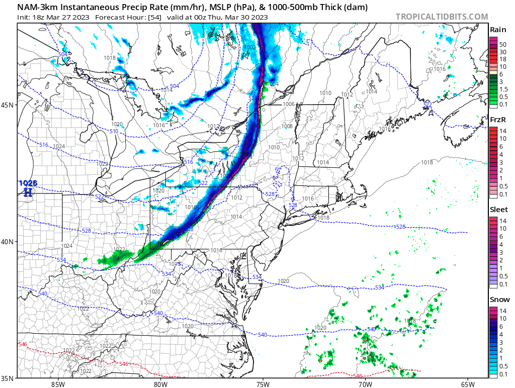
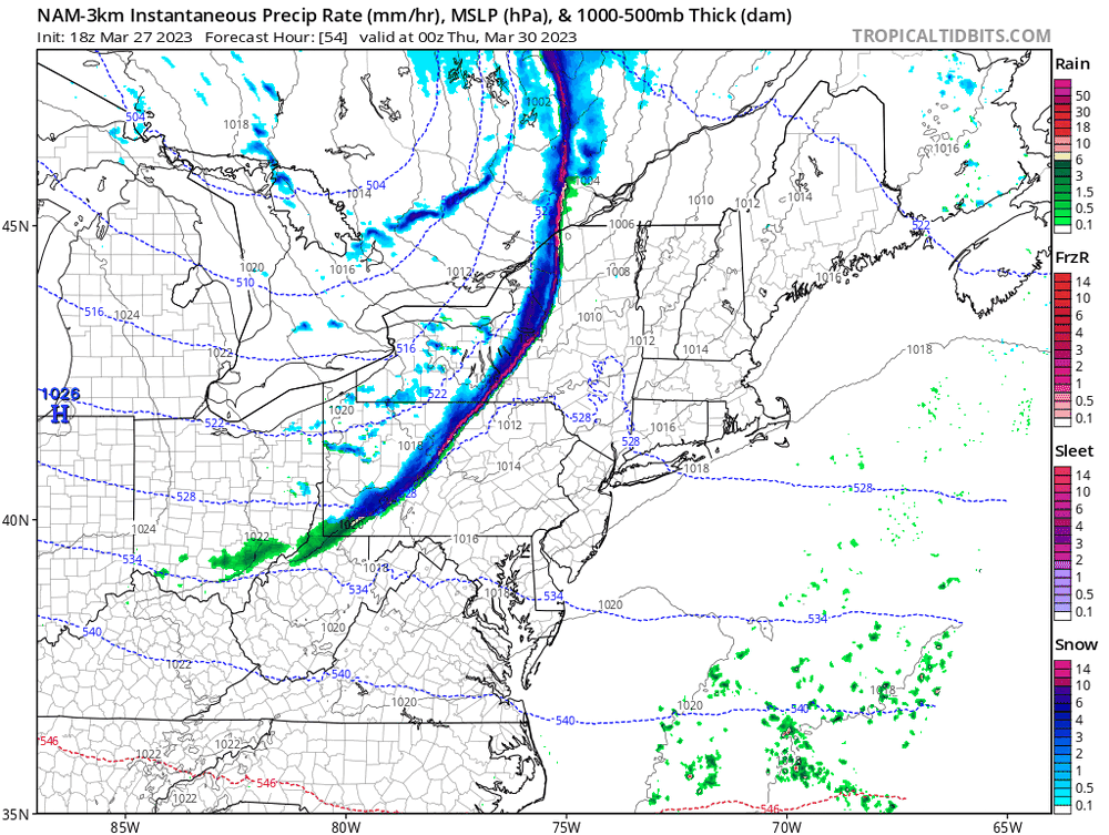
Always always always use the NAM Nest for temperatures in a cold air damming situation when other guidance is faster trying to erode the wedge.
-
Most of Friday looks nasty for sure. That said, we'll end up with a high in the 61-65 range due to the temperature at 12:01 AM.
-
Definitely some sleet pellets mixed in here in southern Howard County. Models are pretty insistent that the heaviest downpours will be after dark - some elevated CAPE suggests that a few rumbles of thunder aren't out of the question.
-
The NAM Nest is pretty clearly a dry outlier; it looks like every other model (including the NAM parent) has snow here tomorrow. You're spot on, though, that the temperatures are super tricky. It's tough to imagine a scenario in which the roads get messy (unless the rates are *really* impressive), but I can definitely envision some accumulation on grassy surfaces and decks.
-
Sort of. The FV3 is the model "core". The GFS already uses the FV3 core. The NAM uses the NMMB core, and the RAP/HRRR use the ARW core. The NAM/RAP are technically to be "replaced" by the GFS. All of the hi-res models (including the NAM Nest and HRRR) will be replaced by the Rapid Refresh Forecast System (RRFS) ensemble system which will use the FV3 core.
-
A couple of corrections here: 1) The SREF is not truly connected to the NAM. Half of the SREF members use the same model core as the NAM, but half use the same core that is used by the HRRR. 2) Neither the NAM nor the SREF has been upgraded in many years, and both systems are due for retirement within the next 2-3 years.
-
While we're enjoying an amazing afternoon, the 18Z NAM just happy hour'd us for Saturday snow.
-
All of the CAMs nicely depict cooler air to our east coming westward towards our area, but they really don't have it arriving until after dark. By then, nocturnal cooling will make it less apparent that a backdoor front is arriving.
-
If one loops back through the older NAM Nest forecasts for this morning, its 00Z cycle last night picked up on the idea that it would take time this morning to bust into the warmer air. 80 is likely now off of the table for most, but at least the low 70s seems likely for much of the DC area with 75 still possible on the south side of town.