high risk
-
Posts
2,802 -
Joined
-
Last visited
Content Type
Profiles
Blogs
Forums
American Weather
Media Demo
Store
Gallery
Everything posted by high risk
-
Wednesday is the synoptic rain, but it looks to go more convective on Thursday and beyond. With PW values progged to exceed 2" for multiple days, it certainly seems like at least isolated instances of high QPF totals and flash flooding will occur, even if the areal-averaged QPF amounts don't suggest the threat.
-

2023 Mid-Atlantic Severe Wx Thread (General Discussion)
high risk replied to Kmlwx's topic in Mid Atlantic
Tomorrow is a low overcast, seasonably chilly day with steady rain arriving - there isn't even a hint of instabilty. Agree that convective chances increase Thursday and ramp up further Friday. -
Tonight's GFS and CMC have it here now on Wednesday. Really hope this is legit.
-
The HRRR has been quite emphatic that this morning line would crap out as it arrived (with redevelopment to our east-northeast); it still really likes the idea of a more significant round 2 later this afternoon (although it verbatim screws the crew along I-70).
-
The question now is whether there is a modest line at the end of the "event" during the latter part of the rush hour. HRRR still says yes, but it's hard to have confidence in the idea.
-
That's not happening tomorrow, but I am hopeful of potentially 2 rounds of convection: one perhaps mid-morning or midday and another late. The 00Z WRF-ARW2 perhaps shows this idea the best. Unfortunately, there is enough "bad look" in some of the other CAMs to make me think that not everyone is going to cash in.
-
2023 Mid-Atlantic Severe Wx Thread (General Discussion)
high risk replied to Kmlwx's topic in Mid Atlantic
I totally hear you on this, but I think there are 2 different types of "speeding up" with convection here. There is the synoptic speed up, where the timing of the front and associated forcing end up arriving earlier, and things erupt on the other side of the Bay. Then there is the speed up of just the actual propagating convection itself - the front is handled well and all, but the line perhaps initiates slightly earlier than progged and then moves east faster.- 2,785 replies
-
- 3
-

-
- severe
- thunderstorms
- (and 3 more)
-
The 100 PoP in my NWS point-n-click forecast for tomorrow is..... brave.
-
2023 Mid-Atlantic Severe Wx Thread (General Discussion)
high risk replied to Kmlwx's topic in Mid Atlantic
Day 3 MRGL is east of here, but the 12Z NAM Nest an HiResW FV3 have slower timing of the front, so convection is better timed for much more of the area. Lapse rates are iffy, but shear is workable. If this trend continues, Day 2 products issued tomorrow would move the MRGL back into our area. Let's get the timing first. Then we can work on upgrading the environment to make it to SLGT.- 2,785 replies
-
- 3
-
-
- severe
- thunderstorms
- (and 3 more)
-
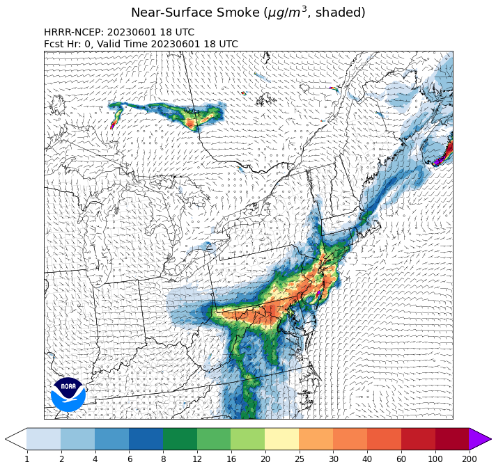
So far, yesterday's HRRR smoke output does not not appear to have a good handle on today.
-
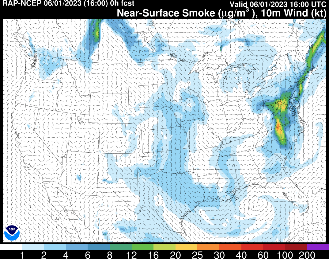
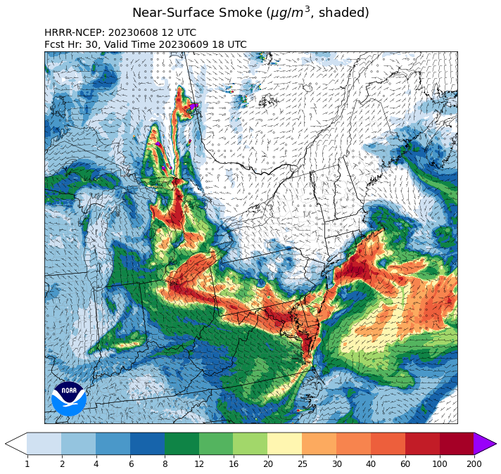
Curious as to why you would say that. HRRR has been pretty consistently showing some pretty substantial low-level smoke concentrations persisting through tomorrow. 00Z cycle this evening 21h forecast valid later Friday afternoon:
-
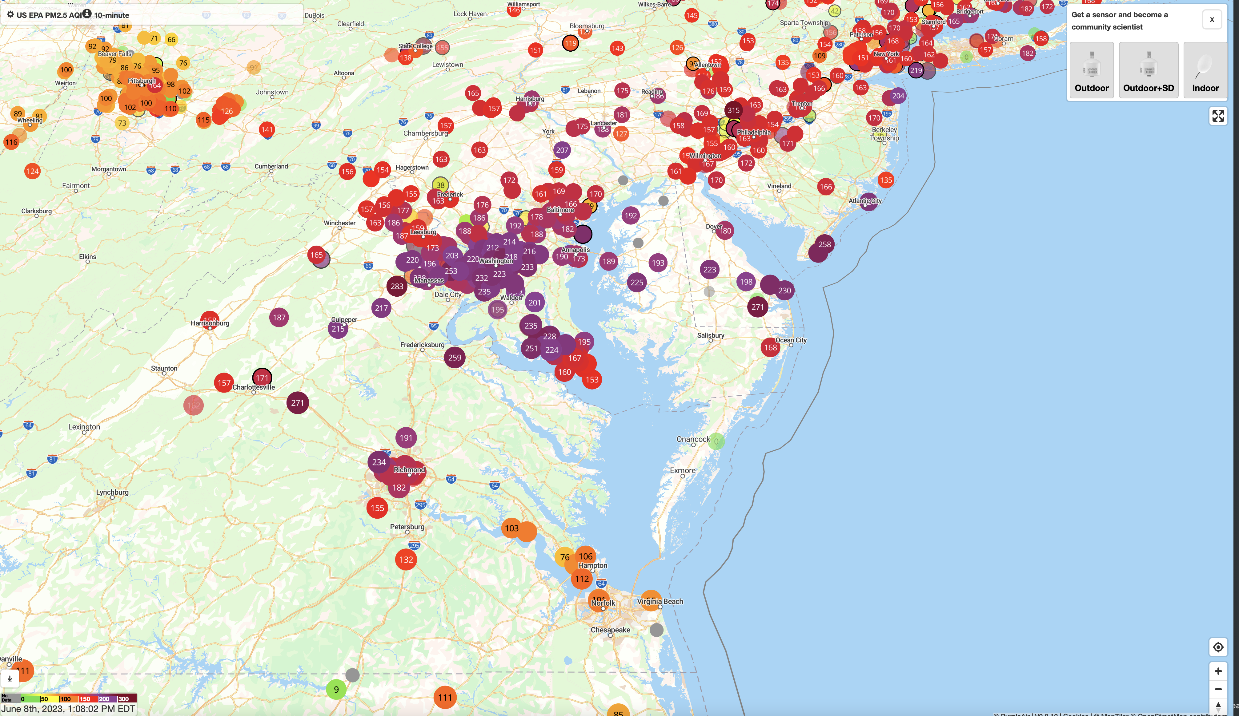
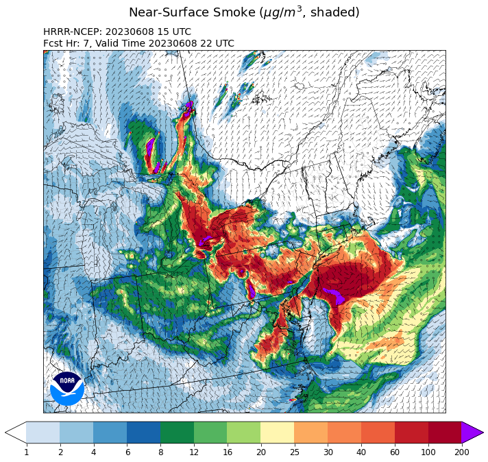
Consistent with reports in this thread, low-level smoke concentrations are dropping in areas north and northwest of DC. Still lousy air but some modest improvement: The HRRR smoke products have been consistently showing this scenario. Here is the latest run's forecast for low-level smoke later this afternoon. Tomorrow, unfortunately, looks worse again:
-
The HRRR smoke very clearly shows the low-level smoke concentrations dropping this afternoon, especially for areas northwest of DC.
-
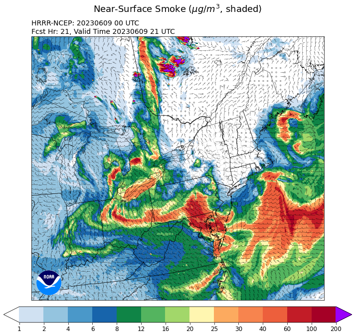
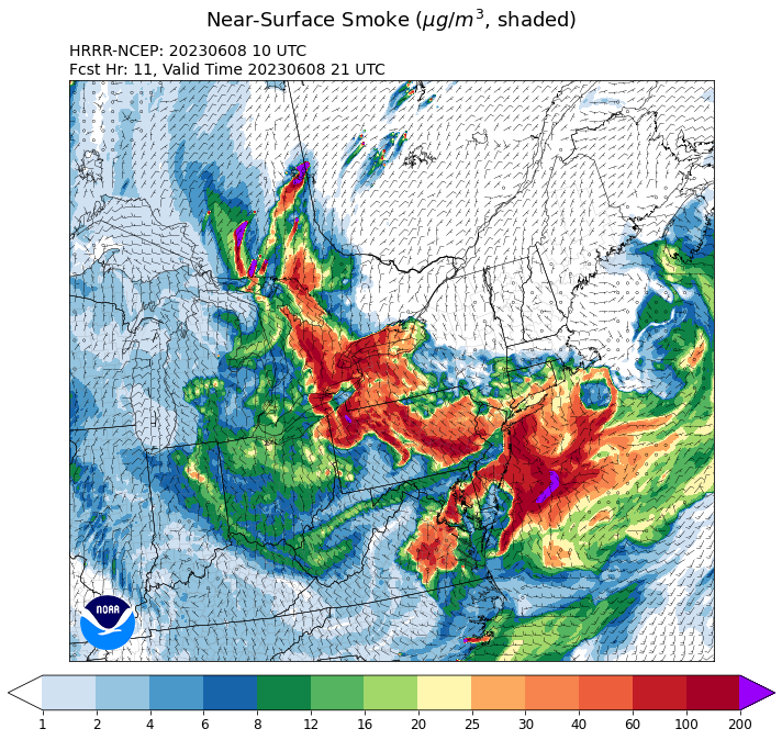
The HRRR smoke products have been excellent at showing the extreme low-level concentrations across our area this morning. The model is showing a significant improvement later today for northern areas, as the heavy low-level smoke is shunted south before another wave of higher concentrations arrives during the late evening. Forecast for 5PM:
-
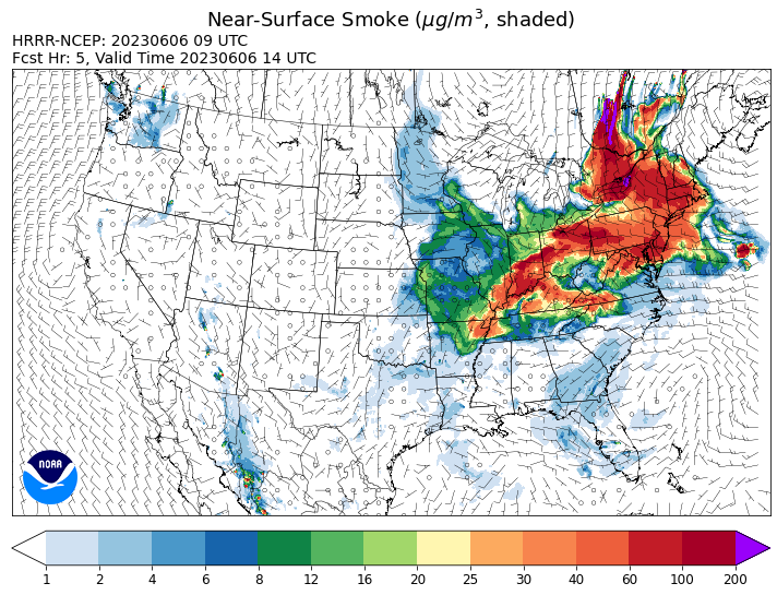
Incredible amount of smoke in the sky this morning, and consistent with what a few others have noted, I'm also starting to smell some smoke. This is consistent with the HRRR smoke output which has shown that the smoke will work its way down to the surface today, starting very early this morning.
-
Agreed. It's bleak for the next week, but all of the ensembles show rainfall flipping to near or even above normal starting next week and potentially lasting at least a couple of weeks. And the deterministic solutions are starting to key in on a potential system early next week to get things started.
-
2023 Mid-Atlantic Severe Wx Thread (General Discussion)
high risk replied to Kmlwx's topic in Mid Atlantic
I *think* you're correct. The MRGL on the 16th got close to the southern counties of LWX's CWA, but it looks like it stayed just south.- 2,785 replies
-
- 2
-
-
- severe
- thunderstorms
- (and 3 more)
-
Ah, you nailed it.
-
Yeah, second week of June looks better, but that is still only "normal" rainfall according to the GEFS, GEPS, and Euro ensembles. The CFS is the only system hinting at above-average rain. And Saturday's opportunity looks to be fleeting for those of us on the east side of the Potomac. The front looks to crash through early and shift the best shower/storm potential to areas west and southwest of DC.
-
Source is fires over Nova Scotia

-
This post did not age well.
-
NAM and GFS starting to come into agreement for an ugly Sunday, with lots of clouds and periods of light rain and drizzle keeping temps in the lower 60s.
-
2023 Mid-Atlantic Severe Wx Thread (General Discussion)
high risk replied to Kmlwx's topic in Mid Atlantic
All good points. As you said, our best potential for a good combination of shear and instability is that mid-May to mid-late-June period. Events prior to that usually lack instability, and events later in summer often lack good shear. That said, we still usually get a few severe watch boxes in July and maybe August, and a tornado season can occur in the fall if the tropics are active.- 2,785 replies
-
- 2
-

-
- severe
- thunderstorms
- (and 3 more)
-
2023 Mid-Atlantic Severe Wx Thread (General Discussion)
high risk replied to Kmlwx's topic in Mid Atlantic
It still kind of looks that way, but wow - it's beyond discouraging for at least the next week and likely beyond for any kind of decent convection. For me, the climatological peak of SVR in the Mid-Atlantic is roughly May 10 to June 20, and we sure are wasting it right now.- 2,785 replies
-
- 2
-
-

-
- severe
- thunderstorms
- (and 3 more)
-
Yikes - the 00Z model suite has really dried out Saturday.