-
Posts
2,832 -
Joined
-
Last visited
Content Type
Profiles
Blogs
Forums
American Weather
Media Demo
Store
Gallery
Everything posted by high risk
-
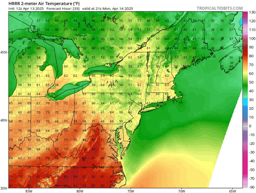
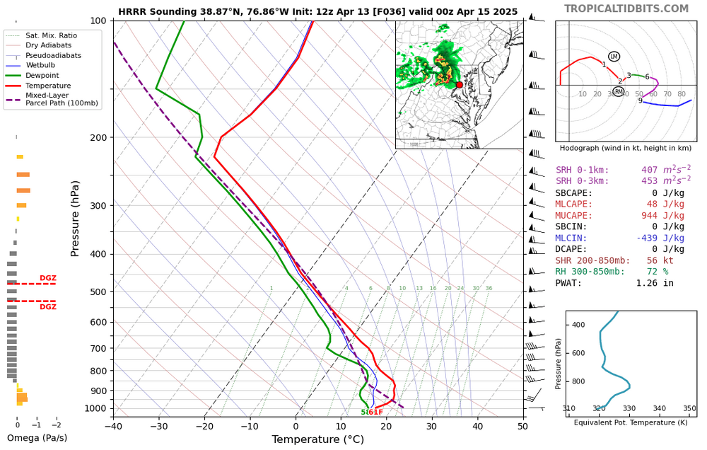
The EML will definitely be there, but the impact of an EML can be significantly lessened if you're dealing with a stable surface layer. You're all spot on that every hour earlier that convection arrives makes a huge difference here. Let's look at the HRRR temperatures, since it's the warmest model. Here is peak heating time: That's plenty warm for the Shenandoah Valley and across most of northern VA, but it's much cooler across central MD, and other guidance seems to be in agreement. Not sure that earlier arrival will help as much for areas east of the Potomac as we think. The HRRR brings convection racing west to east generally north of I-66, and the reflectivity looks super cool, but the forecast soundings in advance are not awesome: Thunder? With those lapse rates generating a good amount of elevated CAPE, you betcha. Shear is super. But that very stable surface layer is going to make it incredibly difficult to get wind down to the ground. And despite the good lapse rates to promote hail, the freezing level is quite high, so the stones would likely melt before reaching the surface. But perhaps the overall speed of the MCS (or whatever you want to call it) will drive some better gusts than this sounding might imply. As mentioned earlier, the dynamics (500 height falls are nice!) are super. As the outlook implies, the highest threat is definitely further west and northwest with lowering threats the farther east one goes.
- 450 replies
-
- 5
-

-
- severe
- thunderstorms
-
(and 2 more)
Tagged with:
-
Simulated radars look really interesting, but the soundings suggest that the convection will be elevated due to early evening cooling and therefore have limited SVR potential. That said, the dynamics are really strong, so this is certainly worth a look.
- 450 replies
-
- 2
-

-
- severe
- thunderstorms
-
(and 2 more)
Tagged with:
-
I mostly agree, but I would tighten the likely score zone, based on convergence of overnight guidance, to between the Bay and Rt 15. Radar evolution so far this morning suggests that this is on track.
-
Concerns: 1) The axis of heaviest rainfall will be relatively narrow; it's not some huge coastal low-induced rain shield 2) We've been in a dry pattern 3) Precipitable water amounts will be decent but not overly impressive Pros: 1) Ensemble agreement is quite healthy 2) There will be a zone of healthy frontogenesis with good flow off of the Atlantic that has potential to target our nicely quite effectively Hoping that the good model agreement that favors us holds overnight.
-
The GFS is kind of all over the place, but the other systems and their ensembles seem to be converging on the idea of at least a modest if not a more significant soaker. Looks like a good test of the theory that good rains progged in dry patterns can often fail.
-
The shield is finally expanding north, although a cutoff of good amounts is still likely somewhere between the DC Beltway and I-70. I suspect that the models are struggling to capture the exact structure of the shallow chilly air mass, leading to misrepresentation of the zone of best overrunning.
-
Yeah, the forcing ended up being north of our area. Disappointing.
-
Yeah, going to be a significant temperature gradient across the area, with a lot of model variation about how the thermal boundaries set up. Convection seems likely along the boundary later in the day - not seeing forecast soundings that impress me, but I suppose that an isolated severe event can't be totally ruled out. Looking forward to the potential for more early morning rumbling tonight, though.
- 450 replies
-
- severe
- thunderstorms
-
(and 2 more)
Tagged with:
-
Good model signal again overnight for early morning convection.
-
Enjoyed the thunder and was surprised by a modest gust front, as I expected a more stable surface layer which would have prevented any downward mixing. But temperatures as the storms arrived were notably warmer than progged, so the storms may have actually been (barely) surface-based. Super disappointed in the rainfall, but the line really collapsed as it approached the 95 corridor.
- 450 replies
-
- 3
-

-
- severe
- thunderstorms
-
(and 2 more)
Tagged with:
-
Based on the 00Z suite, late night convection is pretty certain for areas along and north of I-70. Whether any of it makes it south towards the lower parts of Howard and Montgomery is less clear.
- 450 replies
-
- 2
-

-
- severe
- thunderstorms
-
(and 2 more)
Tagged with:
-
Hard to ignore that signal, but the accompanying forecast sounding suggests that it would be elevated. So it might be rotating, but the biggest threat from elevated supercells is hail, and the overall moist profile and weak lapse rates don’t really support decent hail.
- 450 replies
-
- 1
-

-
- severe
- thunderstorms
-
(and 2 more)
Tagged with:
-
is a slight risk that was downgraded to a marginal really a bust? The models were very clear that storms would be isolated at best.
- 450 replies
-
- 2
-

-

-
- severe
- thunderstorms
-
(and 2 more)
Tagged with:
-
I’ve been saying that today has some sneaky tornado potential, confirmed by the CSU prog above. I think that storm rotation is somewhat likely today but 1) I’m still unsure about storm coverage 2) sfc winds might be a bit weak too weak let’s see how much we warm this afternoon. Nam nest has the coolest temps and therefore the least storm coverage.
- 450 replies
-
- 3
-

-
- severe
- thunderstorms
-
(and 2 more)
Tagged with:
-
I’m not totally sure, but I think they’re referring to the profiles having stronger winds in the mid levels and then weaker winds above, creating looping hodographs. Those can sometimes prevent proper tilting of the updraft/downdraft structure needed to maintain persistent strong updrafts. We’ll see if the upper level winds are really weaker.
- 450 replies
-
- 4
-

-

-
- severe
- thunderstorms
-
(and 2 more)
Tagged with:
-
Yeah, lots of uncertainty, but most of the CAMs (NAM Nest is notably bearish) have at least a couple of cells - a widespread severe event does not appear likely, but localized severe appears to be on the table. I maintain that there is a slightly higher tornado risk; SPC notes the veered surface winds but that may be offset by a greater westerly component in the flow just above. More widespread storm coverage may be possible later Thursday night, but these would have very limited severe potential.
- 450 replies
-
- 2
-

-
- severe
- thunderstorms
-
(and 2 more)
Tagged with:
-
Early take on Thursday: some CAMs have storms in the area by late afternoon or early evening, and some don't. If, however, storms do form, the environment actually features some decent low-level shear and a resultant conditional tornado threat.
- 450 replies
-
- 2
-

-
- severe
- thunderstorms
-
(and 2 more)
Tagged with:
-
Right. Parameters, especially the shear, are very favorable Thursday. But will there be a trigger? As you noted, the NAM says no, but the HiResW FV3 opens the door to at least a few cells in the Mid-Atlantic.
- 450 replies
-
- severe
- thunderstorms
-
(and 2 more)
Tagged with:
-
The QPF signals for that event are remarkable.
- 450 replies
-
- severe
- thunderstorms
-
(and 2 more)
Tagged with:
-
Looking at the morning guidance, there are some definite things to like for tomorrow: forcing arriving at at favorable time of day, good deep layer shear, a warm air mass. Instability wil, however, be a question mark due to modest moisture. The NAM Nest gets dew points into the low 60s which allows for ~1000 CAPE. That would easily support a severe threat. Other guidance has lower dew points, and the instability is lower, unless intense heating compensates. A SLGT is certainly justified; I can’t see an ENH into the DC area at this time unless there is high confidence in instability. I’m also not seeing a 5 TOR threat this far north unless something increases the progged low-level shear.
- 450 replies
-
- 6
-

-
- severe
- thunderstorms
-
(and 2 more)
Tagged with:
-
It bears watching for sure, but events here in the spring in which the orientation of the cold front is parallel to the steering flow tend to not work so well, as we get lots of clouds and multiple rounds of stabilizing showers.
- 450 replies
-
- 2
-

-

-
- severe
- thunderstorms
-
(and 2 more)
Tagged with:
-
Since it's quite severe-wise here, I recommend checking out the setup for Wednesday in the Pacific Northwest. Great shear with the intense approaching trough and surprising amounts of instability.
- 450 replies
-
- 3
-

-
- severe
- thunderstorms
-
(and 2 more)
Tagged with:
-
I know that this is somewhat tongue-in-cheek, but all 3 of those forecasts agree on a very cold air mass to our north and a very warm one to our south. They simply disagree on the location of the boundary. That's really not unusual in any way for a 7 day forecast in spring, even if the difference in sensible weather impacts is massive if you move from one side of the front to the other. And the disagreement is less if one examines the ensembles.
-
Yeah, very close call for southern and eastern Howard.
-
Hi-Res guidance in agreement that heavy showers move southwest to northeast across the east side of DC early this evening. Radar confirms this idea, with thunderstorms now over south-central VA.


