jbenedet
-
Posts
7,091 -
Joined
-
Last visited
Content Type
Profiles
Blogs
Forums
American Weather
Media Demo
Store
Gallery
Everything posted by jbenedet
-
Fold.
-
Seems like teleconnections are broadly shifting from terrible to mediocre. Have to strongly favor in and up until we get closer to the 20th and reassess...
-
More like a back window. Areas north of it are still above normal... Not going to make it much further south than that either...
-
64/49 at PSM and that was as of 11:55 am. Nuts.
-
PSM going into the low 60’s today it seems...60 will be easy...
-
12z NAM says no back door, keep the screen door for the chickens.
-
Jeans and t-shirt weather. Vis Satellite shows sun breaking out for most over the next hour; most will be up into the 50’s when that occurs. short term guidance continues to warm. PSM making a run for 60 today.
-
44/38. big melt well underway.
-
That would smash records. PSM on south has very little to no snow cover already. That area is primed to maximize that window. Timing wrt fropa is good as well.
-
-
Record highs Saturday and Sunday? Looks like near 30F departures for a chunk of the sub forum.
-
Yea. I think this is one of those cases where the tuck really underperforms vs climo. We warm up to near 60 before the wedge makes its strongest push Sunday am. If we had cold at onset of developing wedge, I’d be a much bigger believer on being on the wrong side of the gradient for the duration. I’m thinking the 32F isotherm ends up from Portland to Lake Winne, and has staying power there. Maybe we hit 40ish Sunday morning but warm back up to mid 50’s as surface hp booted East and before fropa.
-
-
Jeeze, trending toward crushing ice storm in Chicago and Detroit...
-
Sell the big wedge on the GFS. GFS did something similar last “tuck event” (Jan 4/5), while mesos never bought in. Similar story to last big ice event that struggled hugely to get 32F isotherm south of ORH. And this setup is a lot warmer still...Fade climo with ++AO, much less southward movement of cold; eastward trajectory predominates.
-
Selling that up to Lake Winne. Going against climo here but that -PNA with shortwave near the Gulf of Mexico is going to do some serious mid level ridge pumping over our heads...
-
Heh, I can see that—Maybe western CT, western MA?
-
With ++ AO/ +NAO, I’d sell that idea south of Bangor ME. Maybe you can hedge down to Portland, but I certainly wouldn’t include much else. The cold has much more of an eastward than southward trajectory with these conditions.
-
There is no tuck with this...weak frontal wave, no Quebec surface HP. The surface CF will be arriving from the northwest... It’s a bonafied torch setup.
-
Okay didn’t realize that. But in the case of SNE, still looks quite unfavorable through the 20th —keep the shades closed but start peeking....Thinking trend is from crap pacific towards zonal flow pattern (first).
-
I’ll def take the other side of this over next 10 days, especially for SNE. Close the shades.
-
This looks just like the GEFS suite...Not sure what he’s talking about here, especially wrt the monster -PNA... I’d feel pretty good about this if we could manage even a very modest -NAO. For now this still looks bad for most...
-
Seeing this less as a redeveloper and more of a continuous SLP that slides east from upstate NY to PSM, deepening gradually along the way...don’t see how this avoids gaining too much latitude for most of SNE. The WAR looks very problematic.
-
Haven’t seen it...But Anthony Hopkins has 50 years on me....
-
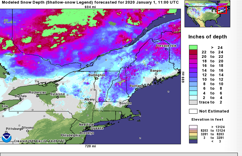
Very poor teleconnection in Jan can work for us, bc “poor” also means less “north/south” phasing of jets, and a chunk of the sub forum ends up on the cold side of the southern Jet, due largely to climo and a progressive flow. The in-situ cold in NNE and southern QC is sufficient for future snow, while the snowcover in the region aids in reinforcing climo. This is a setup for CNE and NNE to do quite well, especially the resorts while SNE really struggles. I suspect I’ll be on/very near the margin. Thinking the next 10-14 days looks a lot like this graphic in terms of heaviest snows/ and frozen/rain gradients.