jbenedet
-
Posts
6,955 -
Joined
-
Last visited
Content Type
Profiles
Blogs
Forums
American Weather
Media Demo
Store
Gallery
Everything posted by jbenedet
-
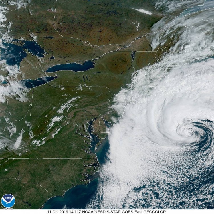
NAM is clearly a warm core system up to Coastal SNE. I’d toss this far if not for the euro showing a similar solution several runs in a row now...
-
I’d be much more inclined to sell the wind threat if this was winter or especially early spring. Mid October climo (SST’s) will —in general—translate to much more efficient mixing down to the surface in the warm sector pre-occlusion and in the eastern half of the system post occlusion. In terms of population impacted we need to see if this west trend persists. What do the impacts looks like if this occludes over Hartford CT or Providence RI vs Portsmouth NH? Worst impacts in terms of wind and surge shift from coastal ME to coastal MA and RI...Low probs at this point, but something to watch.
-
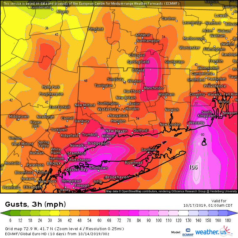
Obviously. Take 30% off those numbers at least. Probably 40% -50% off, inland. Anyway, the exact output with those graphics wasn’t the point. It never is at 72+ hrs..
-
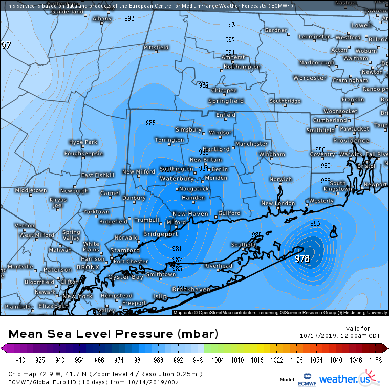
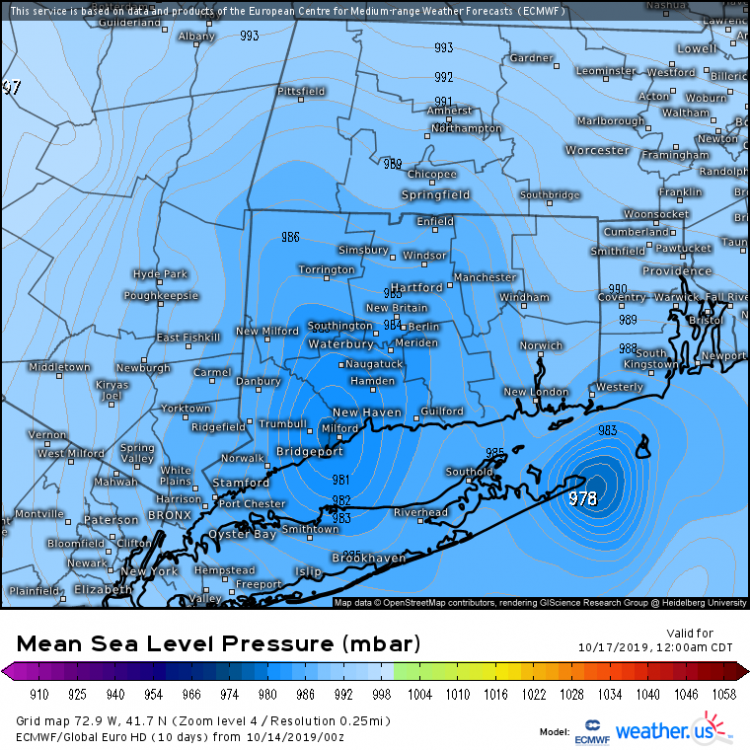
Yea it wasn’t weaker. Looked just as wound up, but further west. Down to 970’s south of CT. The euro continues to show a microcane type feature as well. The the 3hr gust output is obviously hugely overdone (as usual), but linking it to highlight this mesoscale feature....

-
Seems the more intense guidance is reflecting a more tropical connection to the development of the coastal—NAM/Euro—vs the GFS and Ukie. All major guidance continues to trend west, and further from a classic Miller B.. Overall appears like a blend between the two evolutions, A/B at the moment...
-
-
Yea and much of that has to do with communication to the public on a case by case basis. In this situation the classification would do little to change the publics’ perceived impacts/precautions.
-
This should have already been upgraded. I presume they didn’t want to jump from 20% probs to “it’s a storm” in one advisory?
-
Was hoping at this point to see guidance —in general—begin to show more significant deepening. Guidance continues to have mostly Nor Easter type pressure falls (considering the lack of baroclincity) despite early October climo near the Gulf Stream and merging with tropical disturbance to its southwest. I suspect the sub tropical nature of this system will lead to some significant surprises until/unless guidance begins to catch onto this reality. Regardless, the main takeaway is there is no mechanism to drive the system overhead. If this is going to be a significant event it will be via significant pressure falls, enhancing the gradient, NOT a closer pass to the coast.
-
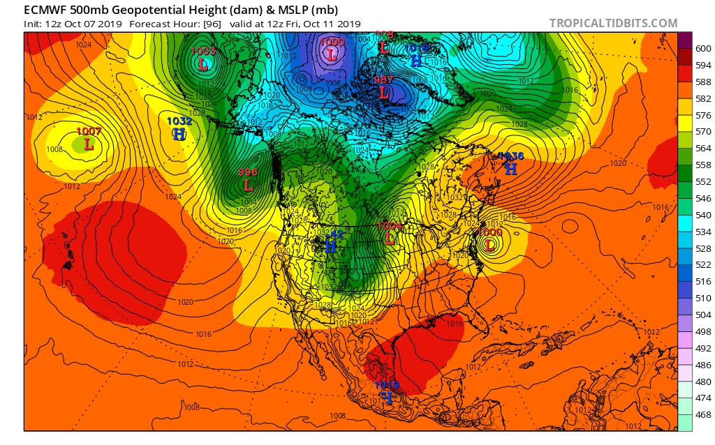
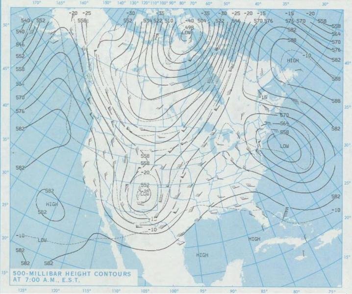
H5 October 31st 1991 vs today’s 12z euro.

-
Just some quick observations: I know I’ll catch a lot of weenie tags for this, but the 12z euro looks like an analog of the 1991 perfect storm, in terms of the major players (NOT impact). Many similarities, including the Halloween blizzard that buried the upper Midwest at the same time. There’s obviously some key differences as well —nothing (yet) has this system deepening anywhere close to the 970’s. The absorption of hurricane Grace helped to make that storm quite unique...*If* anything remarkable can happen with this it will have be through some combination of absorption of tropical disturbances west of Bermuda and deepening as a sub tropical cyclone in and around the Gulf Stream. The GFS is still largely a non-event so confidence in anything impactful is still low... https://www.weather.gov/dlh/1991halloweenblizzard
-
Full moon on the 13th. Event appears to climax on or before 10/12...Worth noting in the event the track trends slower/further west over time...
-
Just a quick look but little surprised by SPC’s limited interest in severe for Wednesday. Antecedent airmass looks great. As does timing for eastern third of the forum. Decent UL height falls...Limiting factor appears to be shear, but that parameter should be conducive in CNE/ NNE, for at least widespread pulse, maybe an MCS in SE NH/ Maine?
-

2019 Atlantic Hurricane Season
jbenedet replied to AfewUniversesBelowNormal's topic in Tropical Headquarters
Think there’s a 50/50 chance we see a lemon over the north central Gulf as this UL trough digs south over the next 24 hrs. Seems to be increasing model support for a weak surface low, collocated with deep convection near LA, tracking east, pretty close to the coast. Little chance this has the environment or time to develop into something more meaningful. Just something to watch. -
Was out at York beach today and was shocked how warm the water is...just checked buoys throughout the Gulf of Maine...lots of upper 60’s and low 70’s already....For early July? Wow...
-
Bro. It’s june frickin 1st.
-
Thinking areas furthest east, excluding most of ME get another chance to torch and push 70 before the cold front. Thinking Eastern MA up to SE NH/ York cty ME in a prime spot for a beautiful first half of the day. We spring.
-
Sky is fairly bright/mostly cloudy already with temp in mid 40’s. I think this turns out to be a really nice day here, by early spring “back-door” standards. SE wind with warm low levels and late March sun ftw.
-
Thinking I manage another 2”-3” in this last band developing in Central NH. It likely will contain the best rates of the storm as I lose the subsidence from the intense banding to the SE.
-
Perhaps a Coastal Storm on March 2nd for SNE????
jbenedet replied to USCAPEWEATHERAF's topic in New England
18z GEFS are juiced. Looks like warning snows for 75% of SNE. SE MA, RI, and extreme SE CT 1” - 1.25” LE. -
March 12/13/14 Blizzard/Winter Storm/WWA etc
jbenedet replied to Bostonseminole's topic in New England
Yea. There was also another Nor Easter last year where the SLP ran over SE Mass but dumped widespread 30”+ in Upstate NY, near Binghamton area. That was due to a similar situarion as this with the mid level tracks being displaced well to the west. -
March 12/13/14 Blizzard/Winter Storm/WWA etc
jbenedet replied to Bostonseminole's topic in New England
Yea unless you live at the base of a mountain. Tell me about it. -
March 12/13/14 Blizzard/Winter Storm/WWA etc
jbenedet replied to Bostonseminole's topic in New England
Careful you’re starting to sound like a -
March 12/13/14 Blizzard/Winter Storm/WWA etc
jbenedet replied to Bostonseminole's topic in New England
Yea this is incredible. More than the past two seasons combined I’d say... -
March 12/13/14 Blizzard/Winter Storm/WWA etc
jbenedet replied to Bostonseminole's topic in New England
AWT. That’s awesome. Band has been fun up here but def not the epic rates you’re seeing in eastern MA. I think Nashua NH area got in the best of it as well.