jbenedet
-
Posts
7,814 -
Joined
-
Last visited
Content Type
Profiles
Blogs
Forums
American Weather
Media Demo
Store
Gallery
Everything posted by jbenedet
-
There's no SE ridge. 240 hr out There's no SE ridge. 180 hr out There's no SE ridge. 150 hr out There is a SE ridge.... 120 hr out
-
So many 200 hr+ maps
-
Agree on timing and temps. But in how these cold tucks work - to be getting delayed is to also to be getting denied. The window of cold narrows, bc the backside timing with the ULL swinging through is still the same. The cold tuck still coming, but weak sauce. And much weaker than modeled across guidance up through yesterday.
-
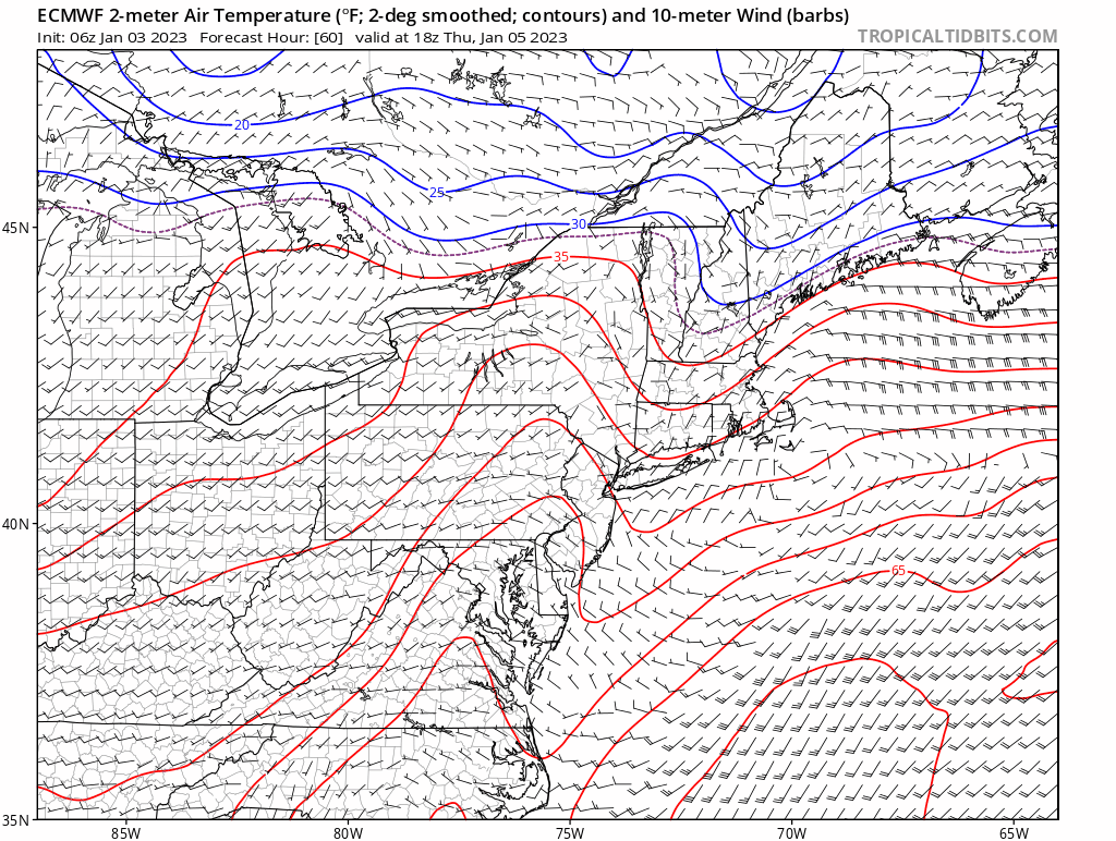
Yea my high per the euro is around 40 but in the morning Thursday. Big difference vs previous runs, which had temps crashing into low 30's starting tonight.
-
Mood flakes on friday. But warm dews and surface temps saying "white rain"
-
lol 12z Euro taken me up to 40's again tomorrow. Someone was saying ice storm at BDL? @Damage In Tolland
-
Yea that's what it is showing off and on. But I believe going to see it flex more often than not during that window. N to AN UL heights. A nagging issue. This look at 144 is very tenuous for example--if that shortwave amplifies slightly, we easily see enough ridging to take eastern SNE out of the game. It wouldn't take much for this to look like a flatter version of the storm we are experiencing right now, which is still too warm for many. But not for far interior, Northern NH, western MA, VT and Maine.
-
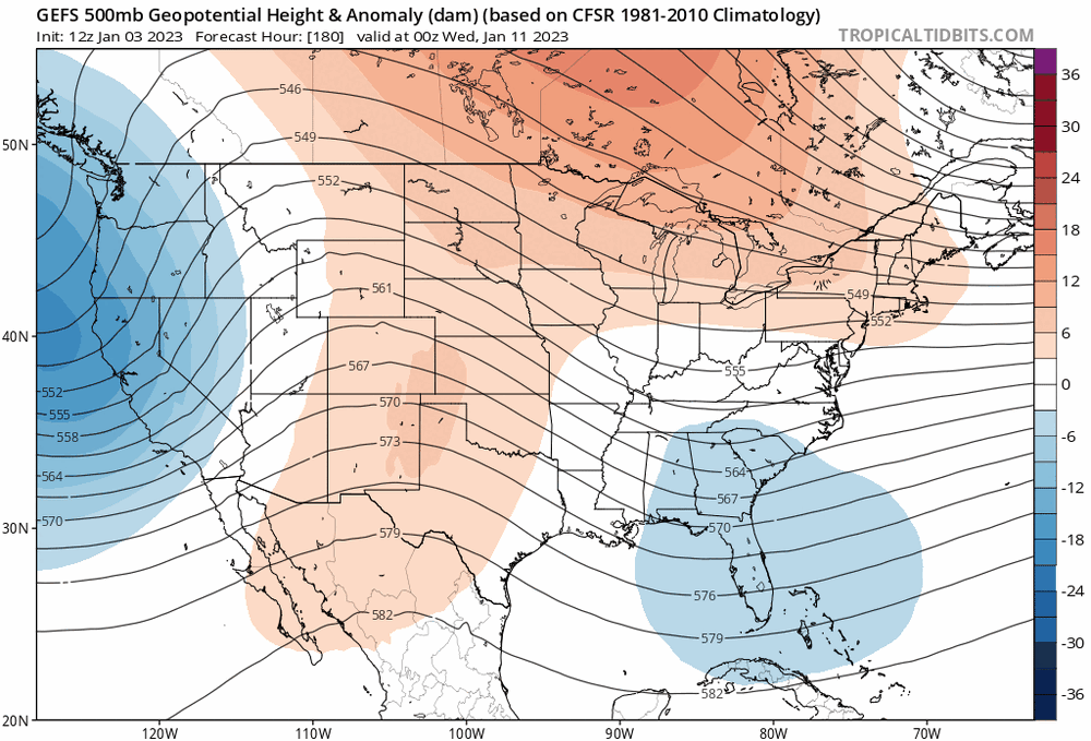
The cold is at least in eastern Canada, vs central/western. We have that. Pacific is poor and that keeps us with AN bias BUT in JANUARY, which is workable (meaning, when the arctic isn't involved) in areas with average highs in the 20's -- western MA, Vermont, interior NH and much of Maine. But the robust SE ridge is also a problem with storms prone to warm sectoring eastern areas. I think longitude will matter more than latitude over next few weeks. West better than north. And Northwest >> SE. Most favored areas for snow chances would be Berks and Vermont.
-
Anyone who would prefer a cold wedge mid 40's and overcast vs 65 and sunny, I don't get. Better off moving somewhere with a worse climate and lower COL. I don't care what the calendar is. Unless the cold is producing, I want nothing of it. 65 sunny on Jan 4 is a huge win. Congrats to those who have it.
-
Yea. Late March, or better yet late November - given sun angle and SST similarities.
-
45 is still like +13 around here. Lol.
-
What a late March look. All the mid 40’s behind the door. Up to caribou before freezing. 70 in Delaware.
-
What makes you so sure? Your bogus mid to long range forecasts? I wonder why we have such high forecast error for shortwaves in datasparse regions of Canada then. My argument is in the precision and accuracy of this. You can get a snapshot. But good luck rolling that data forward into something reliable. "Pretty darn good", in the world of forecasting is actually crap. You are way more confident than what this technology and data can output. Pick a phase any phase: "A butterfly flaps its wings"
-
Do you guys ever worry about how poorly sampled that area is? Like you're analyzing an illusion because the data is so sparce?
-
Using climo blankedly can certainly have its pitfalls. Snow cover, soil temps, lake temps, ocean temps all have a say in it. Broadly speaking, none of these variables are near Jan 3rd norms, for the region as a whole. The one key exception, of course, is the sun angle, which is fixed. But saying it's peak climo right now creates a forecast error trap given the background context. The world around us needs to look like Jan 3.... We can swing back and mean revert to the climate calendar with a string of BN days, but until that happens....caution.
-
No kidding. This is great.
-
Jan 6th threat: H5 has appeal, and will likely continue to, but surface looks too warm, and that’s the prevailing issue. Highest POP collocated with most marginal temps up to 850. Warm antecedent air mass, weak dynamics, and incoming surface cold lags behind. Systems like this where in-situ cold —or lack thereof—makes or breaks it. We know where this case falls. Advisory event if everything works out perfectly, onset during overnight, stronger system. Next.
-
No. I meant would lose all ice. There’s small sections of the Cocheco near the mill dam that’s been frozen over. Also Willand pond the same. Also, watch out for the mosquitoes. They’re back apparently.
-
Looks like the local ponds, lakes and streams will fully open up before this latest ++AN snap ends.
-
Naw. You and @ORH_wxman bitter that I point out that your life work is really just a waste of life. Sorry to break it. It’s a fraternity of losers. To be an outcast is a good thing here. You also undermine the credibility of meteorology. Add that to the list.
-
Yea you really should have. 5 minutes of daily natural observations outperforming 5 weeks of model hugging. Well done. Modelologists making meteorology a farce.
-
That explains a big piece of it. But I believe there’s something else going on. Some recent studies out on how Covid weakens the immune system, especially right after getting over it. This is likely another big piece, and it’s been the pattern in my specific case. The propensity for Covid to trend towards pneumonia has always been the pathogenicity. If susceptibility to pneumonia goes up, I suspect it does too for a whole host of other viruses/bacteria. And yet there’s still more unknowns I believe contributing…
-
Liebniz's chaos theory distills so much. Just running a model with slightly different initial conditions; it's mind blowing the first time you see it. Especially when taken in consideration with the inherent error associated with measurement and interpolation. I believe there are complementary ways to improve weather forecasting accuracy but the bulk of short term "growth" is outside of NWP. NWP will see further improvements as we get more data (measurements over time and throughout the globe at different levels of the atmosphere); and find better ways to incorporate this information continuously into weather models. But this is an under-taking much bigger than one person, which is why I say the individual forecaster should look outside of NWP to improve forecast skill.
-
Nah there's a big difference between me and you. One of us is learning the inherent limitations of NWP (in some cases the hard way), while the other still pours their heart and soul into something that NWP was always fundamentally unequipped for. The devil is in the details. And we all should foremost respect that, as weather enthusiasts and meteorologists. If we don't the field loses credibility. It's not what you don't know that gets you in trouble; it's what you think you know that just aint so... (Every 10+ day detailed forecast)
-
@40/70 Benchmark That is a forecast. Some details to deduce skill. I can respect that, even if I disagree with the methodology. Analogs have value, but at a very high level. Details, likely still to be burnt.