jbenedet
-
Posts
6,955 -
Joined
-
Last visited
Content Type
Profiles
Blogs
Forums
American Weather
Media Demo
Store
Gallery
Everything posted by jbenedet
-

TS Fay - Drought ending Rains and Severe Convection
jbenedet replied to weatherwiz's topic in New England
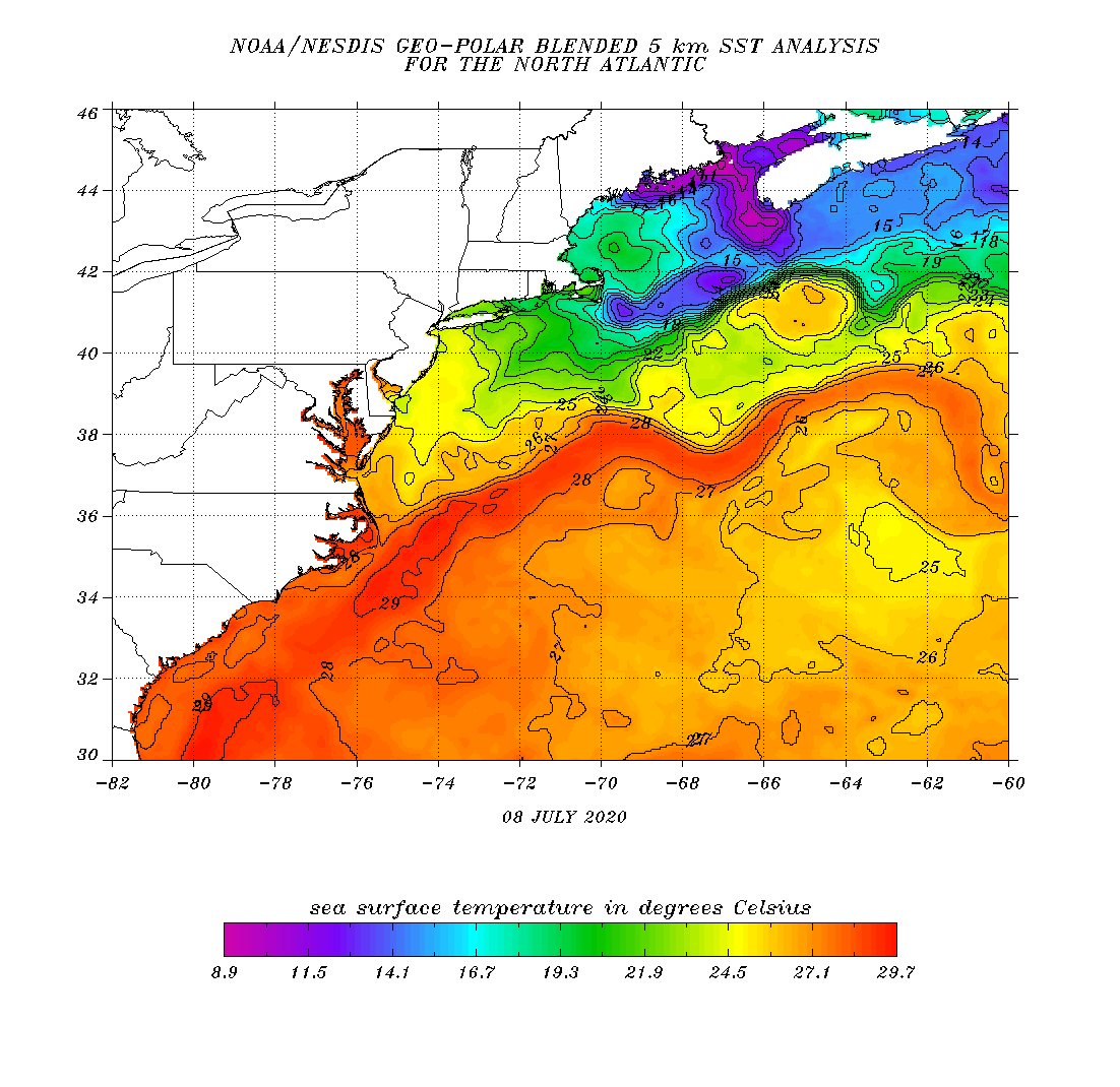
Usually this latitude is where tropical cyclones begin transitioning, non-tropical...BUT 84F SST under that deep convection...Pretty incredible given climo. Certainly conducive to development of a non-sub tropical TC, with hospitable upper level environment.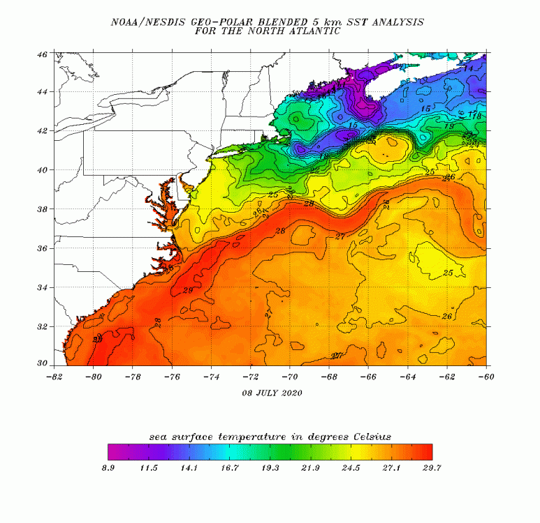
-
TS Fay - Drought ending Rains and Severe Convection
jbenedet replied to weatherwiz's topic in New England
Yea and that’s what the 12z NAM indicated . Granted it’s the nam, but that’s all of the 12z suite we have at the moment. Latest vis does seem to show the convection-less swirl being abandoned for the deep convection east of OBX. -
TS Fay - Drought ending Rains and Severe Convection
jbenedet replied to weatherwiz's topic in New England
I’ll take the other side of this. The CoC is further northeast, and there has been a recent blow up of convection right in that location. I think much better shot this surprises to the upside—intensity wise—than the opposite..Next 6-10 hrs will be quite telling, as it remains over the Gulf Stream. https://weather.cod.edu/satrad/?parms=regional-eastcoast-02-24-1-100-1&checked=map&colorbar=undefined
-
TS Fay - Drought ending Rains and Severe Convection
jbenedet replied to weatherwiz's topic in New England
Northeast quad is where that risk is typically highest, *if* this maintains significant tropical characteristics into the northern Mid Atlantic. With that, I think Long Island, Eastern CT, RI and SE MA, might be more interesting. -
I dunno...This passes as miserable for July weekend weather at FMH. Most obs of fog/mist/overcast. https://w1.weather.gov/obhistory/KFMH.html I went to Hampton beach NH yesterday, to avoid the “stuck in dank” in Maine. It took until 12:30 pm to break into partly cloudy, and then clouds came back in by 4. Really tough pattern for the beaches lately...Used to see this regularly when I lived on LI. And it’s why I never want a beach house in the Northeast as a primary residence...marine boundary layer is a bit$h.
-
I was going to head there today but forecast seems to have only steadily worsened the past 48 hrs right at the coast, especially in Maine.. Thinking will have a much better shot at a nice break further south—Rye NH on south... Damn meso-lows...
-
Saturday, June 27 - Sunday, June 28, 2020 Convective Thread
jbenedet replied to weatherwiz's topic in New England
For Rain. Sell today buy tomorrow. -
I’m doing a rain dance today. This line looks pathetic. Looks like being East might finally work in my favor though....
-
Not sure if you have sinus/snoring problems. But if that’s the culprit, train yourself to breathe through your nose. You will sleep MUCH better I can assure you...No drugs needed, just discipline through the day...
-
Quite the blow up of convection off the Texas Coast...
-
Not really. June heatwaves don’t get enough attention. They are brutal. Heat index, and negative precip anomalies, doesn’t capture the intensity of the sun that accompanies the heat this time of year. Anything significantly exposed to direct sunlight during a heatwave in late June just bakes.....I’d bet some of the vegetation was UV-fried more than over-dried...New England grasses don’t stand a chance...
-
Thinning but still winning
-
Yea. That’s definitely the look out by you. More iffy along the sea coast today with the CF. Nowcasting type deal...
-
Never been happy for a day of misery mist until today. I’d gladly take a day tomorrow too...
-
I got stuck with my wife about 500 ft from summit on monadnock with severe overhead. Was able to quickly hunker down under a large rock... Not sure what I would have done had I not found that...Hail, high wind, CG lightning. Will never forget the sound of the thunder rolling through the valley. Just awesome. Wife was terrified. And she didn’t even know at the time that we were literally the highest point within a 100 miles. I was scared, but probably more fascinated than anything once I found that rock to crouch under. It was a looong 10 min though...Rain nearly flooded us out of our shelter too...
-
Would think this is adequate for a 10% lemon, over next day or two. A weak cold front is expected to move off the southeastern U.S. coast early next week, then stall over the northern Florida offshore waters through Wed. Low pressure may form along the front. The front will weaken into a trough from Wed into Thu. While this takes place, a trough will linger between South Florida and the NW Bahamas. Expect unsettled weather conditions over the waters in the vicinity of the Bahamas and westward to the Florida coast for the next few days. $$ Ramos
-
We have a -NAO/ -AO pattern developing in the eastern CONUS—synoptic scale troughing will predominate. I’m thinking sell the tracks into Texas, and look from central LA coast to panhandle Fla as biggest risk. Also hedge on the faster/more progressive side of guidance...6z GEFS really picking this up...
-
Tropical disturbance near Florida, on the Gulf side would appear Lemon worthy....
-
May 8-9 mid-spring rain, snow, cold, wind obs
jbenedet replied to CT Valley Snowman's topic in New England
I remember when I first moved here and was wowed by the prospect of snow in May. I also believed anything more than a flake was strictly reserved for the white mtn region....clearly having to rethink that especially given we’re 9 days into it. We’re missing accums by a few degrees, it seems, but otherwise generally impressed with the rates and lack of mixing.... Should be great for the garden and lawn.... despite the wintry appeal. -
Thurs looks really close for a big (and cold) nor’Easter. Heads up Maine and far interior. This one could get really interesting for you guys.
-
Today looks nice for most. Late April sun burning this off quickly and dry air advecting into the region. Mid 50’s, broadly, and maybe a few places make it to 60 in western SNE.
-
So how many times did the euro do this inside 48 hrs this past winter season? Too many to count...Many still falling for it though...
-
Strongest winds of the region being observed in SE NJ where that break in the clouds is...that looks like it’s pushing NE. Thinking that’s the max of the wind event for whoever sees a break in the clouds and precip ahead of that line...
-
Has it leafed out down there?
-
I think that will be the differentiator. If that happens this event could meet those high end expectations...