jbenedet
-
Posts
6,955 -
Joined
-
Last visited
Content Type
Profiles
Blogs
Forums
American Weather
Media Demo
Store
Gallery
Everything posted by jbenedet
-
Not weird... The pressure gradient was much more representative of a tropical system at that latitude.
-
NYC looks like a prime spot for tornado threat and high wind threat...Staten Island and Brooklyn are likely greatest risk being exposed to the southeast fetch off the open water... That recent 90 mph gust in Virginia was also reported in the same sector that’s likely to effect NYC area if extrapolate current trajectory...
-
Tropical feeling out there today is legit. Especially with the breeze. Yep a TS is incoming.
-
 The euro initialized with Isaias at 1000 mb 12z Friday. It has him down to 995 mb by 12z Saturday. Isaia’s current min surface pressure is 991 mb. No model, including the 12z Euro has this storm weakening between now and tomorrow. So you take this piece of guidance and you toss....far....
- 1,530 replies
-
- 2
-

-
- heavy rain
- rip current
- (and 1 more)
-
Seasons in seasons. This looks much more like early fall, than mid summer. Tenor of season has been above normal heights over the western Atlantic, and guidance having —in general—to correct higher with time. I don’t see how this misses the Carolina’s...he’s not gaining much of an easterly component before OBX...not this year... NHC’s cone is further east than both the EPS and GEFS. Risk to me seems much greater that this runs well inland than ots...
-
As a cat 1, with a background flow of ~ 30 mph it would translate to impacts more similar to a high end cat 2 in the rear right quadrant.
- 1,530 replies
-
- 1
-
-
- heavy rain
- rip current
- (and 1 more)
-
Full moon on the 3rd.. Surge will likely be a significant impact in the right front quadrant...*if* the storm track is ~perpendicular to coast upon landfall. Will be critical to determine when (exactly) the velocity (track) gains a more easterly component.
- 1,530 replies
-
- 1
-
-
- heavy rain
- rip current
- (and 1 more)
-
Looks like a TS...
-
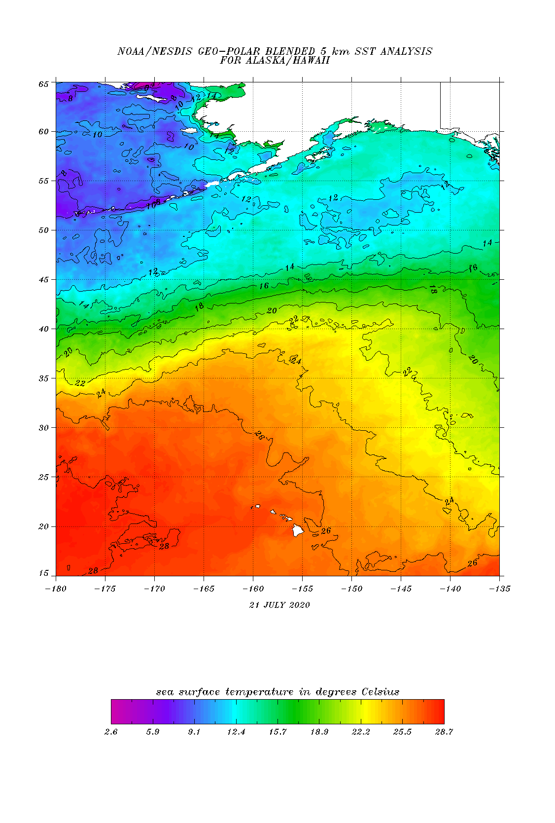
SST’s very marginal true, but I do believe the exact track wrt to the NHC’s latest forecast cone will have an outsized impact on intensity, especially given how fast he will be moving...The southern track would result in gradual weakening, likely still a hurricane, whereas the northern track could see this weaken to a cirrus swirl...before closest approach to the islands...
-
Summer 2020 Banter and random observations
jbenedet replied to Baroclinic Zone's topic in New England
Another nighttime low >/= 70, and another night with short term guidance busting low. Starting to think I should regularly use an N+5 correction for this.... -
I would have. I feel like I brought LI climo with me.
-
When I moved here in 2015, the prevailing wisdom was “pfft, you don’t need AC, this is NH...” Every year I have needed AC, and the need for it has been increasing...I think the much higher low temps is also a persistence phenomenon, going back years...The +AN has been most apparent in the morning, even outside of seasonably warm patterns...
-
Well about 72 hrs out from my post. NHC already assigned 10% chance to this wave...Still think this wave will be most interesting to watch this week.
-
York Beach Maine it is.
-
Looks like development of next threat is about ~84 hrs out. At least that’s what GEFS/GFS is hinting at. Tropical wave passing through Florida strait/over southern Florida and into Gulf of Mexico—general track towards western Gulf coast.
-
Sun out in Dover NH. Outside of Maine, thinking this afternoon could be the main event for most.
-
Looks like a round 2/3, this afternoon on meso guidance.
-
Upper level heights crashing are so easy to under-appreciate severe risk. This morning felt the least primed for big t-storms in a while..., in terms of sensible weather. Minimal sunshine, mostly cloudy, cool, relatively low dews, and then...boom...
-
20 miles to my southeast yesterday; 20 miles to my northwest today. They can keep the hail. Garden destroyer. That cell looks vicious.
-
Another loss for the meh-teorologists.
-
I like today’s severe threat for eastern half. Clouds are breaking up. All meso guidance still clearly on board. The show is in the afternoon.
-
TS Fay - Drought ending Rains and Severe Convection
jbenedet replied to weatherwiz's topic in New England
We haven’t seen a legit CP cold front in quite some time, going back at least a month. I mean, I can’t rule out one, but the point stands. CP air masses don’t typically arrive in the subtropics in climatological summer. That’s basically my point. We’re seeing more subtropics than mid latitude climo lately. A bit of a tangent, but even in winter we had cold fronts that brought us *down* from AN to normal to slightly AN for a chunk of the season. Faux cold. Separate factors then or partially related? Either way, appears a long term “persistence“ phenomenon in 2020... -
TS Fay - Drought ending Rains and Severe Convection
jbenedet replied to weatherwiz's topic in New England
Really seeming like the northeast is the mid Atlantic/southeast in this pattern. Fay didn’t recurve along a surface cold front as one would normally expect. Tropical airmass before and after she passes. Cape cod may be our OBX this year, if you will. Heads up for big TC threats if general pattern persists into August. -
TS Fay - Drought ending Rains and Severe Convection
jbenedet replied to weatherwiz's topic in New England
“Somewhere in the neighborhood of 30 to 50 mph gusts.” Given wind force as an exponential function of velocity, that’s worse than saying the temperature will be in the neighborhood of 30 to 50F. -
TS Fay - Drought ending Rains and Severe Convection
jbenedet replied to weatherwiz's topic in New England
I’ll get a for this, but this already looking like a marginal TS on vis with LLC east of OBX. The naked swirl is a distraction from what looks increasingly apparent at this point.