jbenedet
-
Posts
6,955 -
Joined
-
Last visited
Content Type
Profiles
Blogs
Forums
American Weather
Media Demo
Store
Gallery
Everything posted by jbenedet
-

Active mid December with multiple event potential
jbenedet replied to Typhoon Tip's topic in New England
Hope springs eternal. -
Active mid December with multiple event potential
jbenedet replied to Typhoon Tip's topic in New England
It doesn’t. Was talking about ICON. -
Active mid December with multiple event potential
jbenedet replied to Typhoon Tip's topic in New England
Support from models with poor verification scores isn’t forecast support. It’s just giving false sense of confidence. -
Active mid December with multiple event potential
jbenedet replied to Typhoon Tip's topic in New England
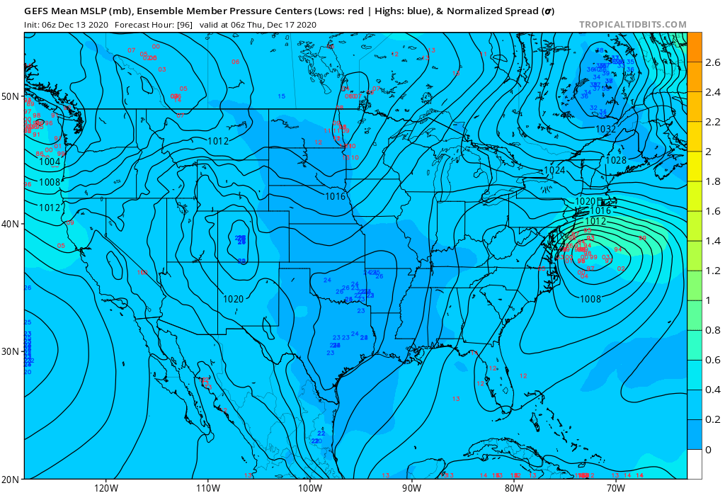
The ukie looks like GFS through 72hr. I don’t buy that 1003 SLP at 96. It should be a stronger system further south... -
Active mid December with multiple event potential
jbenedet replied to Typhoon Tip's topic in New England
Wagons south -
Active mid December with multiple event potential
jbenedet replied to Typhoon Tip's topic in New England
Are we really resorting to the ICON? How have we reached this level of denial already.... -
Active mid December with multiple event potential
jbenedet replied to Typhoon Tip's topic in New England
947 mb low North of NL at hr 72 on the ukie. Weenie crusher.... -
Active mid December with multiple event potential
jbenedet replied to Typhoon Tip's topic in New England
That’s a red flag that the SLP is too far north imo. Disturbance can’t pump downstream heights into a 1038 mb Arctic high anchored over southern QC/NNE. The previous panel looks very similar to 12z GFS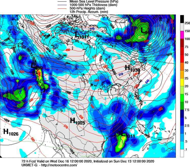
-
Active mid December with multiple event potential
jbenedet replied to Typhoon Tip's topic in New England
The airmass and associated surface HP over NNE is a rock. That’s why the SLP gets shunted East despite sharper UL trough... -
Active mid December with multiple event potential
jbenedet replied to Typhoon Tip's topic in New England
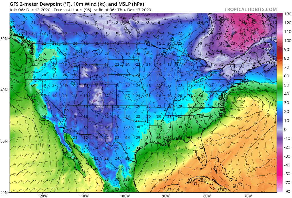
Right now NYC/LI is my “highest confidence area for a significant snowfall”. Right now looks like an all snow event down there to me. Very cold dews should make that attainable... and the mid levels are never an issue with this given the synoptic development....... -
Active mid December with multiple event potential
jbenedet replied to Typhoon Tip's topic in New England
Good questions. My Basis—H5 shows lack of downstream ridging across guidance over eastern CONUS. At same time, the surface Canadian HP appears more sprawling/building rather than retreating... -
Active mid December with multiple event potential
jbenedet replied to Typhoon Tip's topic in New England
The teleconnections support the GFS, imo. Where the arctic is tappable it will be effin cold. And the heart of it just so happens to be closest to NNE at the storms closest approach. -
Active mid December with multiple event potential
jbenedet replied to Typhoon Tip's topic in New England
And you I guess on the EPS...you’re in a *much* better spot than me. This is a cloud forecast up here.
-
Active mid December with multiple event potential
jbenedet replied to Typhoon Tip's topic in New England
QPF looks seriously overdone on north side. 1034 HP anchored over Southern Quebec...might even be sunny in most of NNE... Looking more and more like a Northern Mid Atlantic snowstorm... Which is still great for southern CT, RI and SE MA folks...
-
Active mid December with multiple event potential
jbenedet replied to Typhoon Tip's topic in New England
AWT virga storm outside of SNE. south shore and cape special. -
Virga storm for me I suspect on this one... Congrats to south shore folks. Looks like a good one down there...
-
December 5-6, 2020 Storm Observations and Nowcast
jbenedet replied to Baroclinic Zone's topic in New England
Still getting stink bugs and leaf footed bugs in my place. Lawn is green. A few herb plants I never harvested in the garden are still alive.. Met Winter still a ways off.... -
Dec 5/6th major coastal/ west Atlantic cyclogenesis ...?
jbenedet replied to Typhoon Tip's topic in New England
Funny how this whole thread may come full circle to having to discuss @Typhoon Tip and his global warming thesis. Now this topic is relevant where 1-2C temp anomalies greatly alter the specific outcomes at the margin. And a bunch of us are —curiously— at the margin...I know, I know, it’s still early December climo, which is far from “peak winter” for a chunk of SNE. But I can’t help but look at everything for my area and connect a NWS forecasted 4” snowfall for my back yard on December 5, with a near perfect track/storm bombing in the GOM where we should be talking feet. Ultimately I think this forecast busts low. But* the fact that less than 6” is a high probability at this hr is quite something, imo. Everything would make much more sense if the date was Nov 20, and not Dec 5th... Which I guess is all I’m trying to say... -
12z GFS coming around to “reasonable” but still looks too progressive over eastern CONUS. Doesn’t reflect a -NAO/-AO (unless of course there is a false signal, which I see as unlikely at this point). Slower, deeper, and further south is how I expect this to correct in future runs (with subtlety of course)... I still think this evolves more to a Miller B look, with very dynamic cyclogenesis close to the BM. Either way, very excited to finally have a big storm potential to watch with serious interest.
-
A big storm here will likely be a disturbance that doesn’t blow up until offshore. The Miller A look initially being advertised on guidance unlikely in my view. I think a very dynamic Miller B is most likely...
-
Nice prod. I think western Canada is warm due to Flow over Eastern pacific. But -NAO/-AO means we should be able to tap cold from Arctic to our north and rely less on CP from the west/north west which is skunked from the pacific....
-
Don’t take out of context. I’m not calling for a SECS. Is what I said statistically invalid? Even if odds are 5% at the moment, that’s much higher than during the window I mentioned. Only point I’m making. Most of the big players are on the field...at least there’s that...
-
That’s pretty funny. Best chance, by far, at SECS since April, but let’s “zzzz” at day 6
-
Yes many changes still coming. And I don’t think model accuracy will increase stepwise until tomorrow’s event is somewhat in the rearview...
-
The teleconnections make a significant flip next week, and looks like tomorrow’s cutter will prove to be key in developing the blocking for next weekend’s event. odd to see the euro so warm given UL trough over Eastern conus in early December...at least it’s seeing the significant blocking much more than the GFS. Almost as though you need to overlay the blocking of the 12z euro with the temps of the 12z GFS to get a good idea of what’s coming next weekend...