jbenedet
-
Posts
6,955 -
Joined
-
Last visited
Content Type
Profiles
Blogs
Forums
American Weather
Media Demo
Store
Gallery
Everything posted by jbenedet
-
“No news” Cmon. This is the most important bearish event for US equities since March 2020. https://www.google.com/amp/s/www.marketwatch.com/amp/story/fed-to-sell-corporate-bond-holdings-purchased-during-pandemic-2021-06-02
-
My take: Some time late Saturday night the “warm” front will press northwest of southeast coast as the SE ridge builds and that will set the stage for round two. I say “warm” because it’s the difference of 60’s and low 70’s with dews vs 40’s and low 50’s and dewless...Not warm but relatively...yes... That will set the stage for the tropical —like deluge Sunday pm . Compact Quick hitter, and Monday looks good. 70’s, sunny and dry for most.
-
The euro may not be spelling it out yet but you don’t get broad 3”-6” qpf without a tropical connection. That’s the signal.
-
Those T 850’s have been getting much warmer run to run Sat and Sunday along the coast. I think we see the temp rise all day Saturday through Sunday in coastal sections
-
Pretty good indication on guidance that the SE ridge is going to flex Saturday pm into Sunday. Maybe eastern sections can warm sector before the next round of rain. Don’t think it would take too much to get round 2 to cut west into PA...
-
The part two system looking more like a very weak subtropical/tropical disturbance. I think we’re looking at a tropical airmass with this one—dewy feel... At least we’ll get that... taking anything “summer” I can get at this point.
-
The unofficial start of summer looks like early spring. Current guidance is pretty much the worst weather you can get for this part of the world around Memorial Day weekend. Impressive. Glass half full— it can’t get worse? I think there will be a window of nice (but cool) weather somewhere late Saturday into a chunk of Sunday but the guidance has also done a great job of spreading out the misery so far. Looks like two distinct systems—SNE gets the worst of round one (Friday/early Sat) and eastern New England especially into Maine gets the worst of round 2 (late Sunday into Monday). The high confidence forecast remains: unsettled and below normal Friday to Monday.
-
beaching it today ahead of the front. Front eta 2pm at Rye. Sweatshirts and sweatpants for Memorial Day weekend.
-
Memorial Day Weekend looking a lot more like Easter weekend on guidance. Euro conceding to the much colder and wetter gfs. Big changes needed to turn that around.
-
The exceptional drought out west is most impressive for the fact that it’s worsening while an UL trough is anchored over that part of the CONUS. They’re in terrible shape now given seasonality...
-
Few hundred feet is like 40 miles of latitude. When you go from Portsmouth NH, to the top of MT Washington, it’s like traveling 1500 miles in terms of climate zones and you can do it all in ~3 hrs.
-
Ouch. Not familiar at all with records out there, but if this verified must be close to one... PA/NY


-
Beautiful day in PWM—north; meh day in HFD, crap day in NYC. North and east for the win today. Overcast about an hour from NYC.
-
I’d take this climate of the Faroe Islands, but only if it came with the landscape.
-
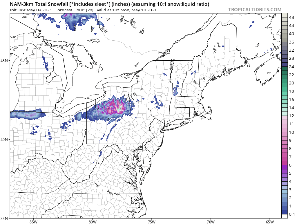
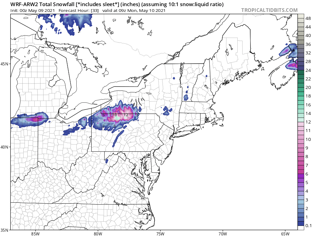
We really aren’t that alone. I mean the northern mid Atlantic knows our pain, bc they’re getting most of it too. That looks like snow in central PA tomorrow, during the day . Storm tomorrow going to move in pretty quick. I’d err on the side of “worse than forecast” . Southern/western sections going to be under overcast probably by 11 a.m.
-
Nova Scotia has been taking the brunt of every nor-Easter since February it seems. Eastern sections of the subforum missed a BIG second half of winter by ~150 miles.
-
That’s a good one. Light Rain in the morning at the coast, storm grazes us. Strong surface cold front through in the afternoon. Temp peaks in low 40’s at PSM. Completely different than today with HP overhead. But anyway yea taking what I said verbatim above—you’re right. Touché. To put it differently: shift this coastal low headed for NS 200 miles west and May 8 2021 would be putting May 9th 2020 firmly into the past.
-
^Beautiful pics but eff snow on May 7, unless it’s at the tops of the whites...
-
About as cool as you can get May 7 with full sun. Thermo read 60 but persistent light wind and very low dews made it feel like mid 50’s at best, even in the sun.
-
We locked into the best winter storm pattern of our cold season starting in mid April. Again. Tough for snow lovers and warm weather lovers. Mother Nature around here figured out how to disappoint the vast majority.
-
May? We’re stuck in early April. May 1st comes in like April 1st. At least the sun will let us put March behind us now... That said, I’ll happily take dewless 60’s most days of the year...Great day for a hike, outside of the far interior.
-
Same here obviously. And this is why day time temps alone don’t tell the tale. Many cold nights, low dews. CP air masses ruled the month—no subtropical air in our region. The entire month has had climo more like April 1–and the vegetation is saying the same.
-
Cooking in Tolland 70/41 OVC, north wind on 4/28 at 1pm. Break out the speedos
-
Nice warm sector. Tanning in overcast with dew in the 40’s. Weenie rage. How is my weather ? Very similar to what’s in your back yard as it should be. 60’s and mostly cloudy—the sensible weather is quite similar for the two of us, being we’re both outside of the warm sector.
-
Where’s @weatherwiz This looks like a good one for him— for a short trip, that is...