jbenedet
-
Posts
6,963 -
Joined
-
Last visited
Content Type
Profiles
Blogs
Forums
American Weather
Media Demo
Store
Gallery
Everything posted by jbenedet
-
The most curious thing is UKie showing this intensity with a slowdown over cool water. There’s def an UL phasing element to this, unlike other major guidance.
-
That is too low —by like half—in the UKie scenario. Lol It meanders/crawls north for 24 hrs after landfall.
-
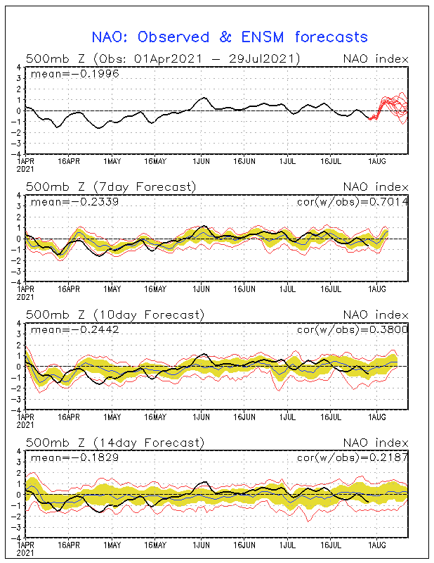
If we get a track close to Long Island I could see this stalling out completely near 40N. This -NAO block is significant and there’s no trough. Henri may be a decaying TC at that latitude but I think the flash flooding risk is a lot higher than currently modeled. Prolonged Easterly fetch in late august with tropical dews.
-
Full moon on Sunday. A blue moon. “Once in a blue moon?” The slower movement but longer duration could mean a bigger threat for coastal flooding than it appears. Surge likely lessened but wave heights greatened. Henri has already been building seas across LI and SNE given his unusual track near Bermuda, in the neighborhood of the mid latitudes.
-
Looks like a non-linear increase in intensity is about to happen based on vis. A step-wise jump from minimal TS to something more akin to a minimal Hurricane...
-

August Disco 2021. Do record dews continue?
jbenedet replied to Damage In Tolland's topic in New England
Took the dog for a 45 min run at 9a.m. Felt a lot more like running at 1p.m. -
August Disco 2021. Do record dews continue?
jbenedet replied to Damage In Tolland's topic in New England
These “low temps” lol. Walking around Dover seeing so many without multiple window units, window fans to try and exhaust the heat. Very few with central air. It’s not a luxury anymore, it’s a necessity. Today will make it 15 days 90+ to date? -
Fred’s most important contribution may be in the impact to Grace’s track. Given current forecast, Fred will likely help build UL heights over the western Atlantic as Grace nears Florida, which would mean a more westward track near southern Florida. A WNW track for next several days, to W? That’s my guess... Biggest takeaway is a recurve east of Florida looks very unlikely at the moment.
-
August Disco 2021. Do record dews continue?
jbenedet replied to Damage In Tolland's topic in New England
NHC should have a lemon off the SE coast. Looks like a non-negligible chance at one of those last minute OBXer’s... Nah instead, what is most likely to happen —if something does get organized—is NHC throws up odds when we all already see a TD on vis. -
August Disco 2021. Do record dews continue?
jbenedet replied to Damage In Tolland's topic in New England
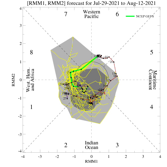
In August this is a signal for a Mid Atlantic/New England TC threat Just Sayin’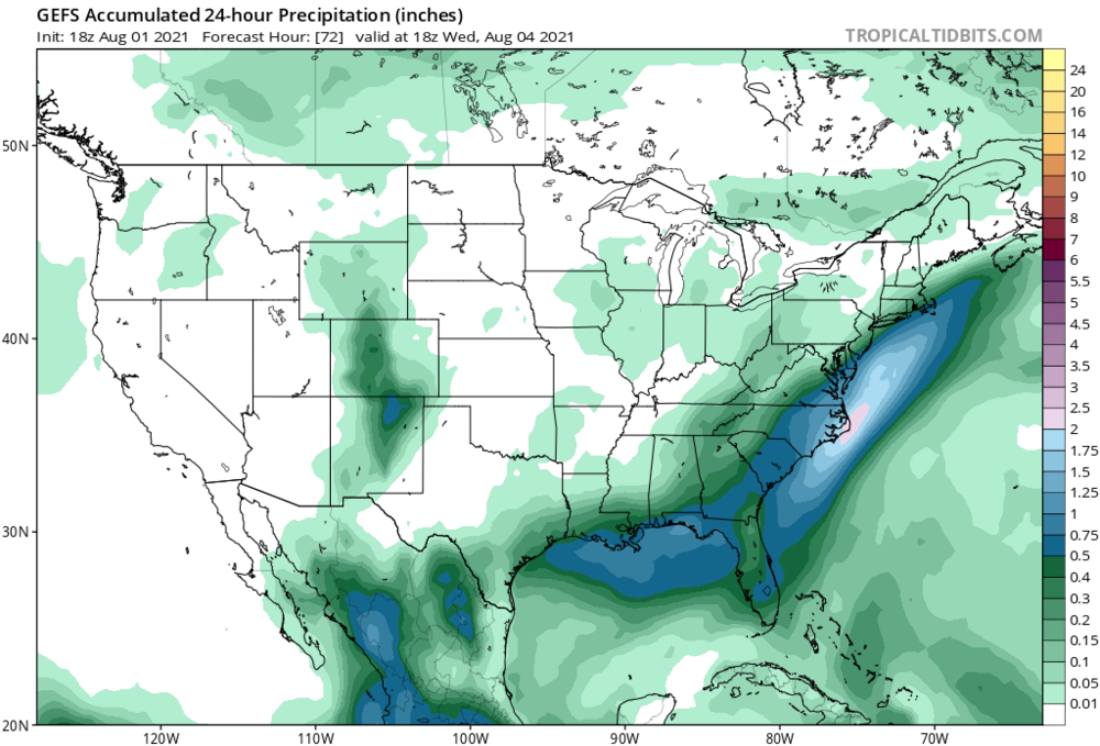
-
August Disco 2021. Do record dews continue?
jbenedet replied to Damage In Tolland's topic in New England
Yes -
August Disco 2021. Do record dews continue?
jbenedet replied to Damage In Tolland's topic in New England
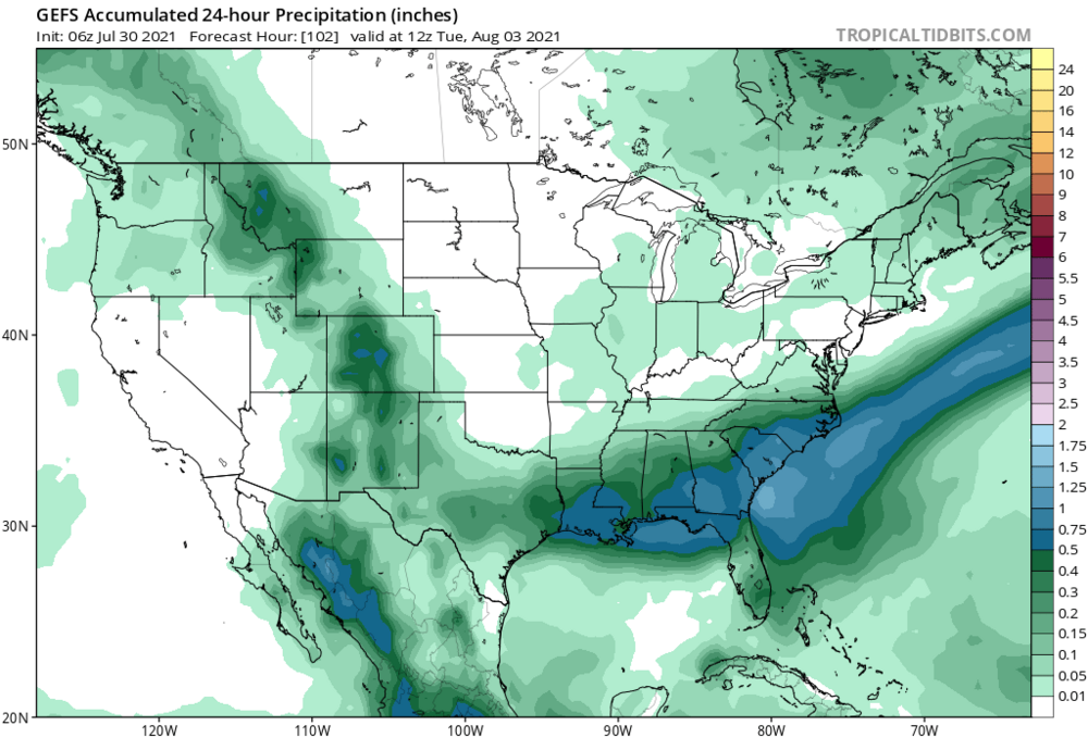
One of those two disturbances on the GFS, Tues and Wed is going to hit us hard. Just a matter of which one. More than likely the 2 weak disturbances are really one, more cohesive tropical/st system...Major guidance just hasn’t resolved it yet. That’s my best guess anyway. -
If you’re going to get a TC up here you need a synoptic setup similar to Tues to Friday, next week. That’s a window for big rains *if* the sleeping tropics could stir something up off the SE coast. A stalled frontal boundary on guidance shows the potential. MJO to phase 8 and timed with a significant pump of the WAR. It’s as if Kevin has written the script for next week.
-
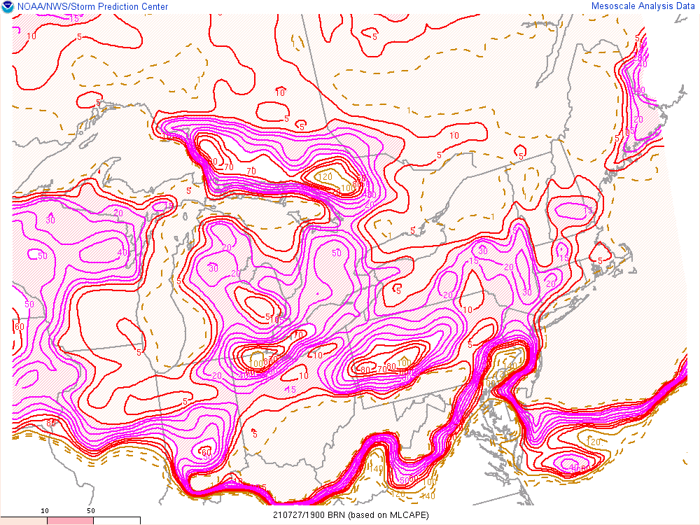
I like BRN’s 15-30 as a general rule of thumb for good chance of severe t-storm conditions. I 84 west up to southern NH away from the coast.
-
Reminds me a lot of winter. Trough overhead but no CP air masses to be found. High temps are BN when we’re socked in but just about across the board, dews are way up and night time temps are at/above normal.
-
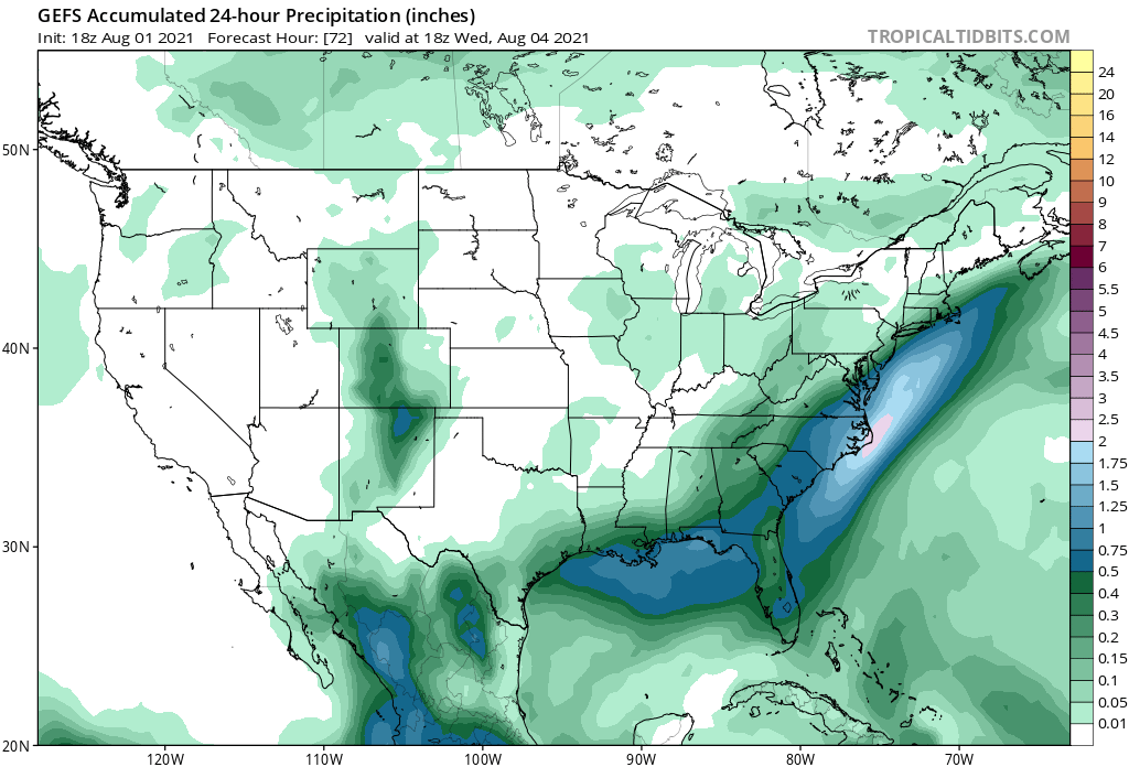
All the record breaking started in June...I mean, just overlay this pattern onto late July and August climatology.
-
Perfect weather for the gardens. Yesterday I yanked my withering snap peas and planted carrots and lettuce for a second season harvest.
-
That’s awesome. My tomato plants are finally fully recovered from the drought and severe heat in June. I did what I could to get out ahead of it, but it was too extreme as to not impose a shock. It was a several-week set back but plenty ripening outside right now... Not to digress..but most amateur gardeners think their plants aren’t producing much bc the soil is lacking nutrients—but if the plant itself is otherwise healthy and green, it’s most likely bc it is lacking water. Fruit and vegetables are ~90% water. The plant will conserve water, if water isn’t in surplus, and that means poor yield.
-
The GEFS and EPS take this over Boston. If it’s a non-event, it won’t be bc of the track.
-
Not your classic TC, long wave trough interaction. It’s really more of a TC and potent shortwave interaction. I dunno what climo is off the top of my head but from what I recall, late spring or especially fall is when we have these come up our way due to more meridional flow that accompanies these seasons. We’re getting into mid July. We don’t have a big Bermuda High..What gives? I’m seeing surface temps in NNE in the 60’s while Areas of extreme northwestern Canada are pushing 90. A lot more baroclincity around the CONUS than one would expect. And that means more UL jet dynamics than one would expect. That’s my best guess as to what intensification the models curiously are seeing.
-
Looks to be hugging the western side of the cone since the 5a.m. update, but that’s just by eye. The track is still North or ever so slightly west of north. Not seeing an East component yet.
-
Highly Asymmetrical appearance; highly asymmetrical impacts. You could be 25 miles west of the center and be experiencing much better weather than those who are 150 miles to the east. For all the disorganization Elsa is maximizing impact by maintaining the center off shore allowing tropical storm impacts to affect the entire west coast of Fla. The eastern side is also aligned with the background flow, adding to the surface wind-speeds.
-
Today will be better than expected outside of East Maine. We are all drying out. It’s got a 70+ feel even up here
-
I’d say eastern SNE is very much in the game. I’m not seeing a deep enough trough to make it interesting for points further north and west.
-
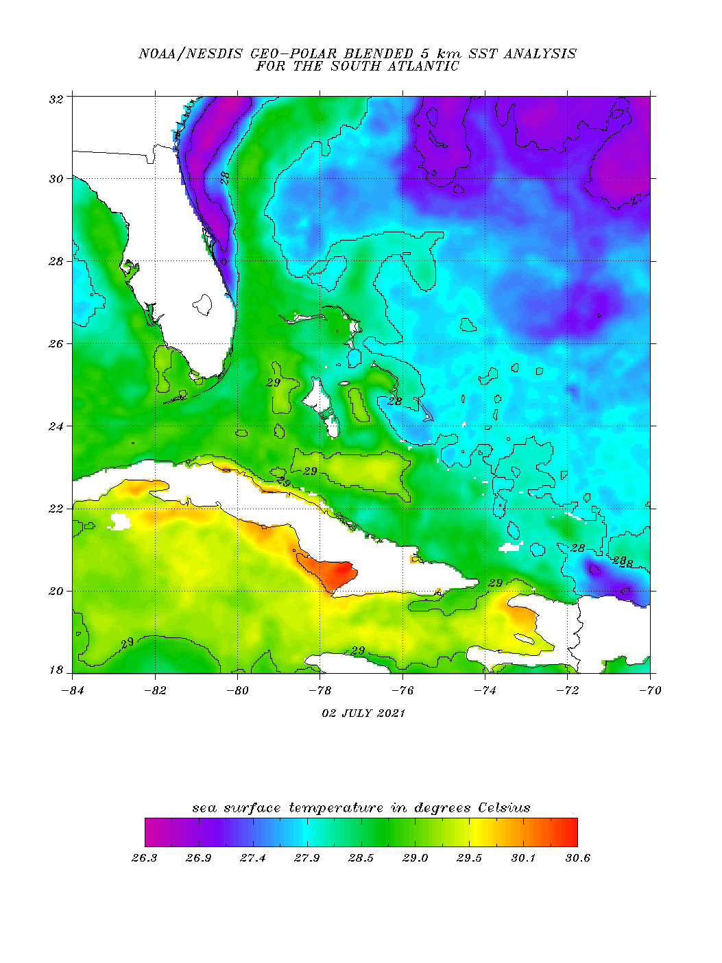
The impediments regarding fast forward speed and significant land interaction —hispaniola, and Cuba have been greatly reduced. And now Elsa is over the warmest SST’s in the Caribbean. This is still a very interesting forecast. Relative to most recent guidance, surprises to the upside in terms of intensity are far more likely than the opposite...