jbenedet
-
Posts
7,815 -
Joined
-
Last visited
Content Type
Profiles
Blogs
Forums
American Weather
Media Demo
Store
Gallery
Everything posted by jbenedet
-
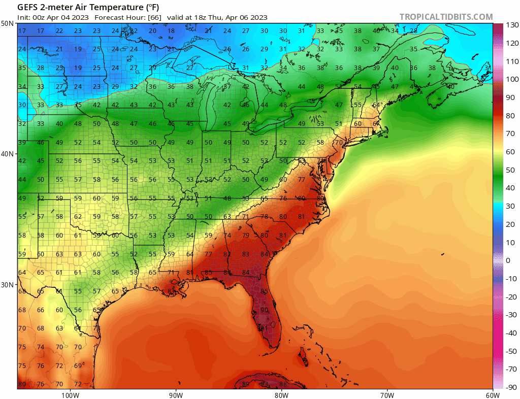
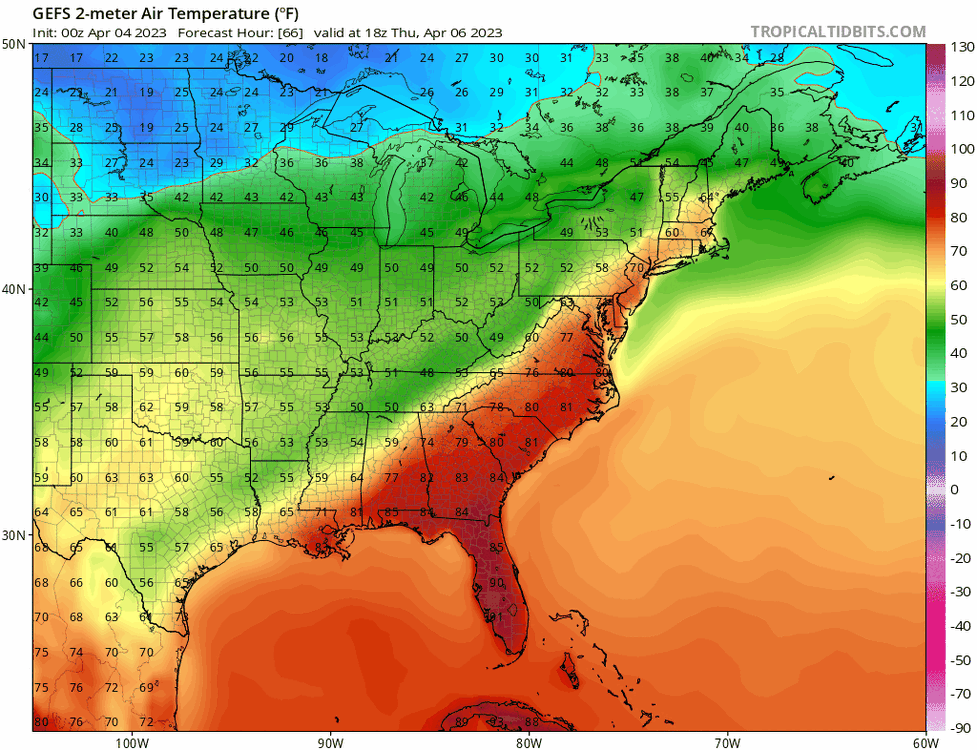
Selling the globals here today. I believe we 60 and sun in SE NH outside of 95. A small victory but it’s all we got.
-
As “decent” as you get around here for the calendar. Occasional break of sun but mostly mid level overcast. 54 for a high will probably do it. Couple degrees BN. Light wind. Sweatshirt is good enough for walking the dog. Looking forward to some heat and humidity. Everything looks tired of the dryness.
-
The back door presses to the northern mid Atlantic tonight, and then recedes back towards CNE by tomorrow morning. I’m very skeptical of the latter part— the teles and seasonality argue for a “best in Maine” setup on Saturday. It’s a pretty classic setup for miserable weather in coastal northern mid Atlantic. I think the door presses South all day today then stalls somewhere around LI tonight and remains there most of Saturday. Saturday has a much better chance of being a shit day to the northern Jersey shore than 70. With that I still think Saturday turns out “decent” up here, but we are definitely running out of time, guidance wise.
-
Usually coastal front here means shit weather through June 1st. But this is San Fran this afternoon. Pretty perfect analogy given how torched the atmosphere is just above the surface on up, with very cold SST’s. Nearby Portland Maine can attain this on the regular but not until late June. 70 with a light to moderate breeze and full sun. Fantastic. You guys can keep the record heat.
-
DAW will finish near euro's numbers. Beautiful out.
-
Temp is about to rip here. South wind fanning now. 30 min we clear out.
-
Morning temps have literally nothing to do with the high temps in this. ISR - it's a high order exponential function today. Either you clear out or you don't. 35 or 45 will still translate to 70ish because of what's just above our heads. Temps below consensus in the morning and then catching up and exceeding guidance in the afternoon is exactly what you'd expect given the known guidance biases in both directions. If most in SNE are still socked in by 12, then the warm breakout is a bust. But latest satellite already shows the dank eroding, broadly, so that's still the bad bet.
-
For those with snow still on the ground - flip a coin?. But for the rest of us, I’ll take the odds that this is our warmest day since October.
-
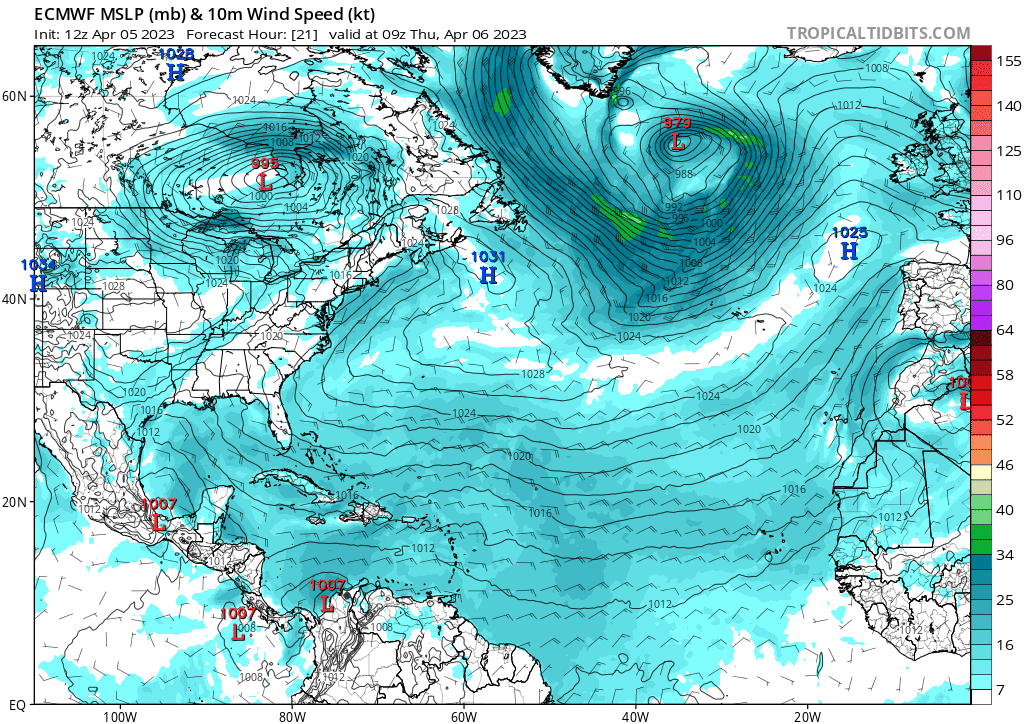
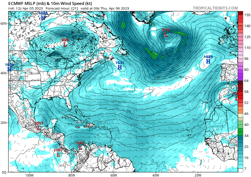
It does given what we're experiencing today, and our climo. But that 1040 canadian high fizzles overnight and is gone by early tomorrow morning, across guidance. It ultimately gives way to a bermuda high by early afternoon. I mean, all we need is the slightest southerly fetch to get there, given how cooked it is just above the surface. And that's what guidance is showing. If there was any semblance of a surface high up in southern QC by 12z tomorrow, I'd say hard sell. But this is lookin' solid.
-
Let's goooooo
-
GFS - now warmest of guidance? Lock it in. GFS won with last weekend's cold tuck that stuck. GFS cave = confirmation that we cook.
-
It’s gonna Tip. Wed will suck but by Thurs, The surface high is fleeting and it’s filling with pacific air. Doesn’t stand a chance; even with all the seasonal caveats. We cook. Bet on it. The EPS and GEFS are also all around WARM by Thurs afternoon. Any Canadian highs long gone…
-
Believe this will be my first winter season here, November through April, each month with below average snowfall.
-
Put some of the hardy outdoor plants back out yesterday morning. They were tired and showing the stress of 4 months indoors, as it was. Wife still thought I was nuts with the snow/sleet fallin’ in the early afternoon. But white rain prevails. 36 for a low. Sun out and a 50F day on tap. Might have to take ‘em in one or two more nights before all clear, but this has been the most seasonal progression since my move in 2015. Steady as she goes—winter gave way to spring right with the calendar, but without any big warm-up. We are springin’ New England style.
-
Cold rains. This -NAO is not gonna produce for the vast majority with the pacific as bad as it is. The snowpack in far interior NNE, Maine and SE canada, just reinforces the blocking in the east, and precludes warm sectors for the rest of us down to the Northern Mid Atlantic. Oof. Weather that makes you wanna move.
-
Long Island and the cape could easily.
-
We've seen a great improvement thanks to technological enhancements and fine-tuning the theory. Not even debatable. My basis is we're stagnating here, and it's not because of the former; but an over-reliance on it. And some take this further with an arrogance to ignore everything else, "we know everything, that's relevant to weather forecasting". No, we don't. In mathematical terms, we've hit a forecasting asymptote. More effort of staring at models is not creating more accurate forecasts.
-
Yes and it's also why experts, generally are terrible forecasters. They tunnel. They are a great resource but they don't understand (or value) the present outside of their very narrow focus.
-
Also, I've learned in the art of forecasting, it's really much less about seeing into the future, and instead fully (and accurately) understanding the present. Models can hinder forecasting ability, if misused. We all want to see an image of the future. It's eye-candy and easily abused. Addictive. If you get the best picture (wholistic) view of the present, you can then better predict the future. To KNOW the present is to see the future. I've become a zealot for Lorenz and chaos theory. If you are after accurate forecasts: Know the initial conditions as best as you can; forget most everything else.
-
I don't do this anymore. The pay-off is not worth the risk. And by risk, I mean opportunity cost. I have learned; mostly the hard way. Now I monitor the weather and try to improve my forecasting abilities to enhance the productivity of my outdoor hobbies; mostly gardening. Much better balance of risk/reward.
-
You were spot on about how active this winter was. I'll def give you that. Nice call in that regard. Marginal boundary layer temps prob cost me 30" in white rain this year. Snowfall accums are a bitch to forecast; vast majority don't appreciate how right you can be, and still be wrong. It's extremely stressful for that reason.
-
I was down in Greenville SC recently and you could see into the past how the base of the longwave troughs were displaced too far west for us this season, persistently. They didn't have snow to show for it, but the landscape looked like it had been shocked into cold many times this winter. Just 500 miles in longitude but that difference really meant a lot for SNE/CNE and into SE NH. You can see it even on latest guidance. Interesting...
-
Agreed. It's like Jan - early March were all, mostly late November; with brief winter interludes. With the sun doing it's thing, now we have late March/early April looking sensible weather. Seasonal, for the most part. Still not pretty but at least bare ground and longer daylight hours make outdoor spring activities possible. I'd really love a late March warm front past Bangor, right about now....
-
Some more tidbits for the naturalists: Friend spotted large hungry bear in Barrington, messing with his bird feeders last night. Out from hibernation. Cocheco is least frozen since mid January. Both observations following a pattern of "normal", and no big warm fronts. Oh yea, and the latest guidance looks like persistence. CPC is also warm. I'm calling this winter over for SNE into SE NH. We spring.
-
DSD. We 50 today.