jbenedet
-
Posts
6,963 -
Joined
-
Last visited
Content Type
Profiles
Blogs
Forums
American Weather
Media Demo
Store
Gallery
Everything posted by jbenedet
-
Snowpack gone. The most efficient pack-eater I’ve seen this area, this time of the year. Good news is it’s been replaced by grass—green grass. So could be worse. Looks and feels like late March. Not a shock considering it’s looked and felt like this since Mowvember with very few exceptions. Weenies rather stay glued to comp monitors and models rather than take a walk outside and see what Mother Nature is saying.
-
Record highs in early Jan. Sucks. But what can you do. Troll land still recovering from that .05” ice storm?
-
I’ve been rotting every day near 40 since Christmas. Miserable. More grass than snow now visible. No one said shit about the interior boonies. But the next few weeks, misery loves company — Break out the Bean boots Mahk.
-
Lol. The next 2 weeks look like trash for SNE snow weenies. Long rain coats.
-
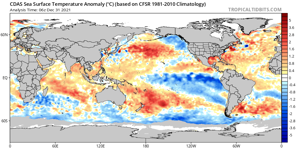
Everything important happens at the margin, 1 to 2 F in surface temps is huge. For as long as these SST anomalies persist this is hugely critical for the coastal plain; i.e, the most densely populated area of the sub forum. Good talk.
-
90% of the winter storms here have been a mixed bag since I moved here summer 2015. I’m not “fine” any year or storm for that matter. This year is starting off the same. I see a bunch of weenies fighting persistence that seems to be more entrenched with each passing year… Interior NNE of course is an exception to this.
-
“Meaningless”. Most live in the coastal plain. Of course this isn’t meaningless for them. Outside of the cp, I think it’s an important factor in a line —extreme southern Maine down to New London CT—ish. If there isn’t prevailing CAD/WAD we take on the in-situ airmass and that’s predominated by the GOM. This affects surface temps at the margin in many critical ways that modeling doesn’t fully capture—hence the extremely tight gradient in New England climo. The snow capitals like Burlington and the Whites—yes I agree that this could be fantastic for the far interior.
-
The pacific isn’t our only problem when it comes to the cold this season. Check out our backyard—the Gulf of Maine. Looking and feeling a lot more like Northern Ireland Climo. A northeast fetch spells rain for a chunk of us with SST’s in the mid to upper 40’s. This going to be a tall bar to get over for the SNE folks (me included) in less-than-great setups/patterns.

-

December 2021 Obs/Disco...Dreaming of a White-Weenie Xmas
jbenedet replied to 40/70 Benchmark's topic in New England
I left it out bc there isn’t one. 0.1” in northwest MA, southern VT and southwest NH? The 6z NAM is really warm and says even that’s a long shot. -
December 2021 Obs/Disco...Dreaming of a White-Weenie Xmas
jbenedet replied to 40/70 Benchmark's topic in New England
The grinch couldn’t script it better for you CT weenies. An inch of snow on bear ground, Christmas Eve morning. Sunrise Christmas Day, rain begins and lasts most of the day. -
December 2021 Obs/Disco...Dreaming of a White-Weenie Xmas
jbenedet replied to 40/70 Benchmark's topic in New England
I dont know what you consider weak but this looks like sub 990 on its closes pass to my back yard... There will be a well-defined warm sector with this. -
December 2021 Obs/Disco...Dreaming of a White-Weenie Xmas
jbenedet replied to 40/70 Benchmark's topic in New England
40's. I don't see a surface HP anywhere in Quebec. -
December 2021 Obs/Disco...Dreaming of a White-Weenie Xmas
jbenedet replied to 40/70 Benchmark's topic in New England
"12/26 event" will really be Christmas afternoon starting. And it gon rain for 95% of subforum. Grinch wins again. Better chances than not I warm sector. Would be nice to get rid of this dreadful ice. -
December 2021 Obs/Disco...Dreaming of a White-Weenie Xmas
jbenedet replied to 40/70 Benchmark's topic in New England
Lol after all that—rain on Christmas for 90% of us. -
Prostates, leaves, lawns and who has the biggest blower—I haven’t missed shit in 6 months apparently.
-
Makes me feel like the insurance companies co-opt the NHC on these. It may just seem like semantics, but it’s a lot of money for those guys.
-
Awesome. Looks like a once in 25 yr event for south shore MA.
-
1020 mb anchored over New Brunswick. Get a 975 mb just south of the cape—do the math— dP/dR…it’s gonna blow. We’re already seeing that classic cold tuck kink in the isobars. I think our tropical disturbance is going to have a much easier time, physically speaking, hooking in closer to RI and eastern LI than by first approaching the Gulf of Maine. We’ve seen this movie before.
-
Coastal appears moving faster than global guidance. At this rate I think pm tomorrow is the worst of it—evening hours to midnight. Could make for quite the left hook if the H5 low continues east at a much slower pace, similar as progged.
-
1014 mb to 988 in 24 hrs on the 6z GFS?
-
Big difference I see in track is the GFS has essentially a strong TS/minimal hurricane that phases; whereas the other global do not—a TD/min STS. The more vertically stacked the TC, the more delayed the phase, the further east it is likely to be. At the same time the H5 low has been trending north on all guidance. It’s coming north, but how far west? Really wouldn’t want to bank on the GFS without finding a closed low off the SE coast first. The GFS is showing rapid deepening of the coastal low today. This alone would be quite anomalous…
-
The low level flow has an easterly component. Look at surface to 850 mb wind directions off the East coast 24-48 hrs. A non-vertically stacked (weak) TC will end up further west than a baroclinic low that is driven by upper levels.
- 306 replies
-
- 2
-

-
- heavy rain
- damaging wind
- (and 1 more)
-
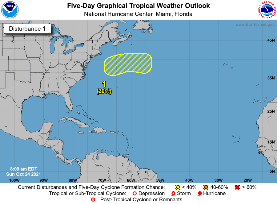
NHC still behind the curve. I think the Northern Gulf disturbance will exhibit the characteristics of weak TC much sooner than what their graphic depicts (I mean at least they finally acknowledge the potential). The 6z GFS has a TD/STC off the southeast coast in 30 hrs. Either way break out the notes on hybrids/STC’s … Intensity-wise, most of this passes as semantics, but the big takeaway is what this evolution would mean for track. A true tropical development would bring the surface low tucked in (north/west)…
- 306 replies
-
- 3
-
-
- heavy rain
- damaging wind
- (and 1 more)
-
October Discussion: Bring the Frost-Hold the Snow
jbenedet replied to 40/70 Benchmark's topic in New England
This airmass really moderated vs the guidance from a week ago. I guess my bitchin’ paid off. No frost here, and the threat of rain the next few days with onshore flow means the garden is still in the clear for the next few weeks. I’m happy. -
October Discussion: Bring the Frost-Hold the Snow
jbenedet replied to 40/70 Benchmark's topic in New England
There’s a sig tropical element to this guy, and it’s October —waters near the BM still support a TC. So this will be more dynamic than a potent nor’easter. Adjust expectations accordingly.