jbenedet
-
Posts
6,955 -
Joined
-
Last visited
Content Type
Profiles
Blogs
Forums
American Weather
Media Demo
Store
Gallery
Everything posted by jbenedet
-
Been raining for an hour here, but appears DAW still snow. 10 miles will once again mean all the difference.
-

Monitoring a potential important TV to East Coastal storm: Jan 17
jbenedet replied to Typhoon Tip's topic in New England
That’s a valid point—but won’t be until after midnight…. -
Monitoring a potential important TV to East Coastal storm: Jan 17
jbenedet replied to Typhoon Tip's topic in New England
Stronger storm. seeing a bunch of meso lows south of LI across guidance. As usual, will be interesting to see how much this slows the easterly fetch and quick torch. -
Monitoring a potential important TV to East Coastal storm: Jan 17
jbenedet replied to Typhoon Tip's topic in New England
It’s Jan 16. The sun sets in 3.5 hours. Temp peaks around 2 p.m. this time of year. 21 high is my bet. dew dropped from -6 to -7. -
Monitoring a potential important TV to East Coastal storm: Jan 17
jbenedet replied to Typhoon Tip's topic in New England
16/-6 at DAW NWS with 23 for a high there. Ain’t happenin’. 50% odds DAW doesn’t see 20F. -
Monitoring a potential important TV to East Coastal storm: Jan 17
jbenedet replied to Typhoon Tip's topic in New England
Really difficult forecast for DAW. -
Monitoring a potential important TV to East Coastal storm: Jan 17
jbenedet replied to Typhoon Tip's topic in New England
-4/-12 at DAW this morning and latest guidance showing mostly rain for Monday. Quite the swing. -
Monitoring a potential important TV to East Coastal storm: Jan 17
jbenedet replied to Typhoon Tip's topic in New England
And then remember that common misconception, which everyone with some met knowledge likes to repeat: “the upper levels dictate the surface”. But synoptic wave development is a positive feedback mechanism—the upper levels drives the surface and the surface drives the upper levels. If at the surface we have an arctic high anchored UL heights can’t be pumped over our heads and the phase in PA happens southeast of LI or the Gulf of Maine instead. -
Monitoring a potential important TV to East Coastal storm: Jan 17
jbenedet replied to Typhoon Tip's topic in New England
It's like you almost forgot everything about New England cold tucks in one sentence. Well done. -
Monitoring a potential important TV to East Coastal storm: Jan 17
jbenedet replied to Typhoon Tip's topic in New England
But the surface HP would not have been stronger, and therefore "more anchored" if SST's were near normal? It's an important factor for eastern new England and especially the coastal plain. But one amongst many. The end. -
Monitoring a potential important TV to East Coastal storm: Jan 17
jbenedet replied to Typhoon Tip's topic in New England
Now queue up the list of imbeciles who will interpret this as "so you're saying it will never snow in eastern southern New England bc of SST's?!" Of course not-- just more needs to go "right". -
Fine at hr 96? I mix often here. Very often. Local climate is 75/25 PSM/DAW She's coming west. Check out the H5 trend in Quebec.

-
That’s my thinking as well. SLP ends up going over PSM or MHT then ENE. Great storm Berks and most of interior NNE.
-
Ya you got me alright. Guy, so butt hurt, forgot what my point even was. Or maybe you still cannot comprehend it? “It’s *impossible* for coastal New England to get measurable snow bc of ++SST anomalies is the GOM” Is this what you’re trying to say I said? I’m surprised you didn’t pick a clown map in Colorado.
-
Makes sense for your area, with the elevation and away from the coast. Cutters would do a lot more damage than a persistently easterly fetch off the relatively warm Gulf of Maine. Not here.
-
That was a good one. I still think this tops it though. There’s no way to tell for sure but my area had a shit ton of ice within the 4-6” snowpack that was here. Probably another 0.5” LE. It was a rock solid base that was not in any way captured by the volume of snow on the ground.
-
It’s all relative of course. Under a foot all the way up there this time of the year is weak. You have deep winter climo so you’ll be fine going forward, regardless of the pattern. My comment was more about what’s transpired year to date.
-
Snowpack gone. The most efficient pack-eater I’ve seen this area, this time of the year. Good news is it’s been replaced by grass—green grass. So could be worse. Looks and feels like late March. Not a shock considering it’s looked and felt like this since Mowvember with very few exceptions. Weenies rather stay glued to comp monitors and models rather than take a walk outside and see what Mother Nature is saying.
-
Record highs in early Jan. Sucks. But what can you do. Troll land still recovering from that .05” ice storm?
-
I’ve been rotting every day near 40 since Christmas. Miserable. More grass than snow now visible. No one said shit about the interior boonies. But the next few weeks, misery loves company — Break out the Bean boots Mahk.
-
Lol. The next 2 weeks look like trash for SNE snow weenies. Long rain coats.
-
Everything important happens at the margin, 1 to 2 F in surface temps is huge. For as long as these SST anomalies persist this is hugely critical for the coastal plain; i.e, the most densely populated area of the sub forum. Good talk.
-
90% of the winter storms here have been a mixed bag since I moved here summer 2015. I’m not “fine” any year or storm for that matter. This year is starting off the same. I see a bunch of weenies fighting persistence that seems to be more entrenched with each passing year… Interior NNE of course is an exception to this.
-
“Meaningless”. Most live in the coastal plain. Of course this isn’t meaningless for them. Outside of the cp, I think it’s an important factor in a line —extreme southern Maine down to New London CT—ish. If there isn’t prevailing CAD/WAD we take on the in-situ airmass and that’s predominated by the GOM. This affects surface temps at the margin in many critical ways that modeling doesn’t fully capture—hence the extremely tight gradient in New England climo. The snow capitals like Burlington and the Whites—yes I agree that this could be fantastic for the far interior.
-
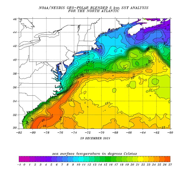
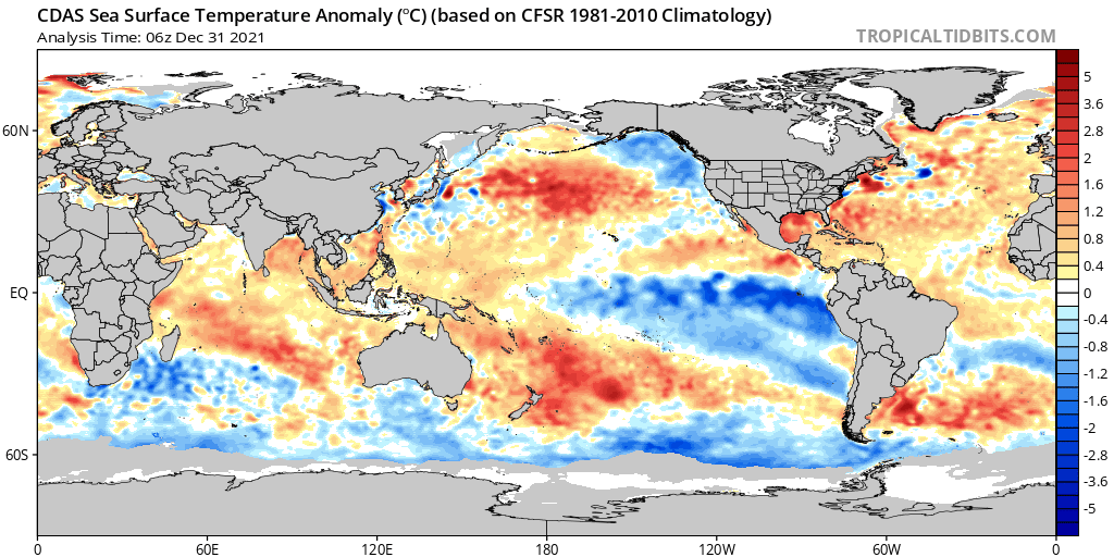
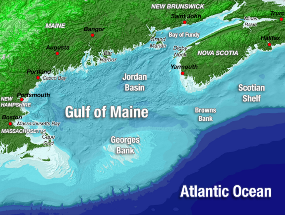
The pacific isn’t our only problem when it comes to the cold this season. Check out our backyard—the Gulf of Maine. Looking and feeling a lot more like Northern Ireland Climo. A northeast fetch spells rain for a chunk of us with SST’s in the mid to upper 40’s. This going to be a tall bar to get over for the SNE folks (me included) in less-than-great setups/patterns.