jbenedet
-
Posts
6,955 -
Joined
-
Last visited
Content Type
Profiles
Blogs
Forums
American Weather
Media Demo
Store
Gallery
Everything posted by jbenedet
-
you pay a hefty premium for nicer weather than that. I’d move if I loved this weather. If not wanting to leave the country, get something dirt cheap in down east Maine.
-
Long Guidance is brutal. Haven’t seen a legit tropical airmass (warm sector) since late October and none in sight. Dewless 50’s are a reprieve in late winter but into late April, it just flat out doesn’t cut it anymore. welcome to Scotland
-
First day in forever with a dewy feel. Noice.
-
I don’t radiate well—on a hill here. Also I believe this time of the year is great to start—many days of cool rain and less pests. So long as you can avoid the frost it’s a good risk/reward bet.
-
Feeling pretty damn good about giving the grass the first mulch cut and planting >50% of the garden vegetables yesterday. Will likely do another 25% today.
-
Thurs into the shittah. Cruel early guidance. Those 80’s stuck in South joisey. That’s turning into a “best in ME”, surface HP overhead with the back door down to the northern mid Atlantic. Oof.
-
You’re way off on these numbers, especially since Covid. Covid (more remote work) + housing bubble + no interest on savings has a ton of people owning more than one home.
-
Lol. COL is way too high for this shit weather. Why? New England has too many transients—people who live here only 3-6 months a year and stay in their Florida Condos the other 6. Resi real estate inflated. And those small businesses we all love also take the hit, paying high rent for 12 months on revenues of half the population for 6. “Look at all those nice homes! Great demographics! High Disposable income!” Ehh, but the occupants are 1500 miles away bro. Check back in May. Oof.
-

March 2022 Obs/Disc: In Like a Lamb, Out Like a Butterfly
jbenedet replied to 40/70 Benchmark's topic in New England
We 60 Best day in the next 10. Left work early. Time for a beer. -
March 2022 Obs/Disc: In Like a Lamb, Out Like a Butterfly
jbenedet replied to 40/70 Benchmark's topic in New England
EPS/GFS is BS for second half of next week. Yea sure that Wednesday shortwave could cut into Manitoba but it’s not eroding the confluence over the northeast US. What most likely happens is it does cut, but then cuts off quickly and fills and we still have a trough overhead with the BZ over the northern mid Atlantic, primed for a secondary. Snow threat is legit through the 1st. -
March 2022 Obs/Disc: In Like a Lamb, Out Like a Butterfly
jbenedet replied to 40/70 Benchmark's topic in New England
Friday and Saturday look pretty damn decent. Friday especially- that has low 60's written all over it for the NH seacoast. Huge win before we see the worst weather next week. Next week we winter in spring. Out with a bang. -
March 2022 Obs/Disc: In Like a Lamb, Out Like a Butterfly
jbenedet replied to 40/70 Benchmark's topic in New England
Thurs looks interesting for a frozen mess from the monads to dendrite and dryslot. -
March 2022 Obs/Disc: In Like a Lamb, Out Like a Butterfly
jbenedet replied to 40/70 Benchmark's topic in New England
Who does yard work in running shoes. This guy. -
March 2022 Obs/Disc: In Like a Lamb, Out Like a Butterfly
jbenedet replied to 40/70 Benchmark's topic in New England
In like a butterfly out like a lion. -
March 2022 Obs/Disc: In Like a Lamb, Out Like a Butterfly
jbenedet replied to 40/70 Benchmark's topic in New England
Threadin’ the needle today. Gorgeous. Shawts on. -
March 2022 Obs/Disc: In Like a Lamb, Out Like a Butterfly
jbenedet replied to 40/70 Benchmark's topic in New England
I agree on the temps IF we get the sun. Problem is this pattern looks very active too. I’ve been out with the bike and longboard plenty times in sub freezing temps this year so yea, I’ll take 50 and dry any time in early spring. Just no more snow please, unless it’s a doozie. -
March 2022 Obs/Disc: In Like a Lamb, Out Like a Butterfly
jbenedet replied to 40/70 Benchmark's topic in New England
Will be creating a reason to do every task outside today. I don’t think I sniff 60 again for a while. -
March 2022 Obs/Disc: In Like a Lamb, Out Like a Butterfly
jbenedet replied to 40/70 Benchmark's topic in New England
We really don’t have to wait long at all. We can table the theory. The first bowling ball starts rolling in 48hrs; at hr120 is trending towards validating the worst this time of year has to offer in the northern mid Atlantic and SNE. Whatever NNE ski country that hasn’t tossed in the towel should be happy. -
March 2022 Obs/Disc: In Like a Lamb, Out Like a Butterfly
jbenedet replied to 40/70 Benchmark's topic in New England
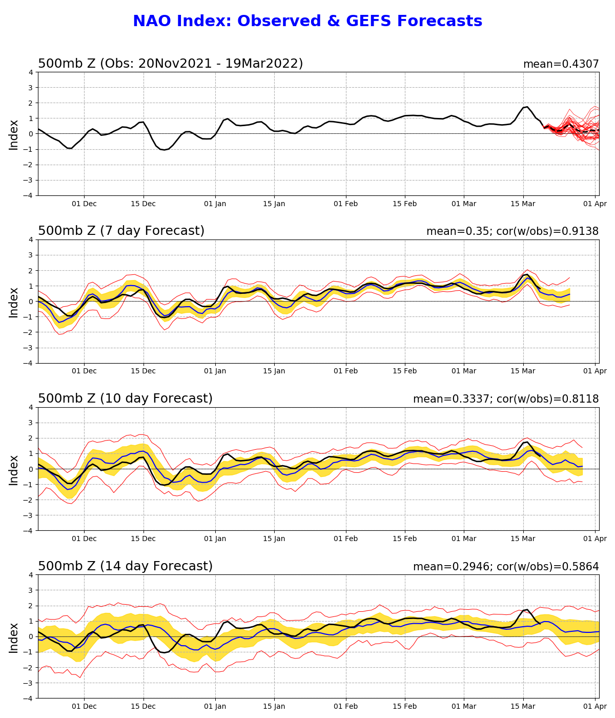
That’s just not right. The first day of spring. Haven’t had -NAO all frickin’ winter. Now it shows up. Again. This persistence has really sucked. It’s too damn expensive to live up here with climate this bad. Signs outside do make one want to say winter’s over. But it’s a damn trap. The teleconnections and major guidance are painting an ugly picture. Just like this time last year and each year before that…
-
March 2022 Obs/Disc: In Like a Lamb, Out Like a Butterfly
jbenedet replied to 40/70 Benchmark's topic in New England
Today looks pretty damn decent too given the calendar. In between the breeze and in the sun will have a very early spring feel this afternoon. Down-sloping FTW. I’ll take a high of 35 less than 24 hrs after a fropa. -
March 12 Rain to…more rain? Maybe some snow
jbenedet replied to HoarfrostHubb's topic in New England
Lol this storm sucked. Immensely. Sunshine before sunset? -
March 2022 Obs/Disc: In Like a Lamb, Out Like a Butterfly
jbenedet replied to 40/70 Benchmark's topic in New England
Oh I get it. BUT 1002 mb low in southern ontario and 1007 mb low south of LI - March 9. Antecedent airmass is AN. Maybe if lived in the carolinas I'd get excite about stuff like this. Seriously. The H5 vort essentiality evaporates. Looks more like a weak fropa than anything else. QPF has clowns clownin'. Fast forward to 18z Wed, when it's 42 at BDL with precip moving in on a south wind, and weenies waiting for sunset. -
March 2022 Obs/Disc: In Like a Lamb, Out Like a Butterfly
jbenedet replied to 40/70 Benchmark's topic in New England
Dunno what this optimism is for a light snow event on Wed. The whole thing looks like trash. Winds out of the south. Timing is very early afternoon Wed--no help there. And even if you get the best synoptic look as advertised on the euro/rgem, surface temps are cooked, and rates are too low to overcome. Flakes and wet surfaces, at best. NEXT. -
March 2022 Obs/Disc: In Like a Lamb, Out Like a Butterfly
jbenedet replied to 40/70 Benchmark's topic in New England
Tossed and burned. -
March 2022 Obs/Disc: In Like a Lamb, Out Like a Butterfly
jbenedet replied to 40/70 Benchmark's topic in New England
SE NH could eek out another 60F+ today if we avoid the bulk of the warm front clouds/precip and get some sun instead. Going to be close. The atmosphere is plenty warm, and supports it. Looking at temps and sky conditions this morning, better chance than not PSM sees 60 again today.