jbenedet
-
Posts
7,815 -
Joined
-
Last visited
Content Type
Profiles
Blogs
Forums
American Weather
Media Demo
Store
Gallery
Everything posted by jbenedet
-
 @Damage In Tolland is a child in a man's body. @40/70 Benchmark spends months analyzing in agonizing detail, but is outperformed by a 3 min read of the outside world. @ORH_wxmanWill show excitement on every storm, regardless the potential. The biggest green tag weenie, that rope-a-dopes the cohort of idiots and enables the weenie cliff-dive. A true depression driver. @WinterWolf Eats squirrels and is proud of it. Circus of rejects.
 -
You guys have the mute button. Use it. But you don't...I wonder why? Circus. Echo chamber for imbeciles and terrible forecasters.
-
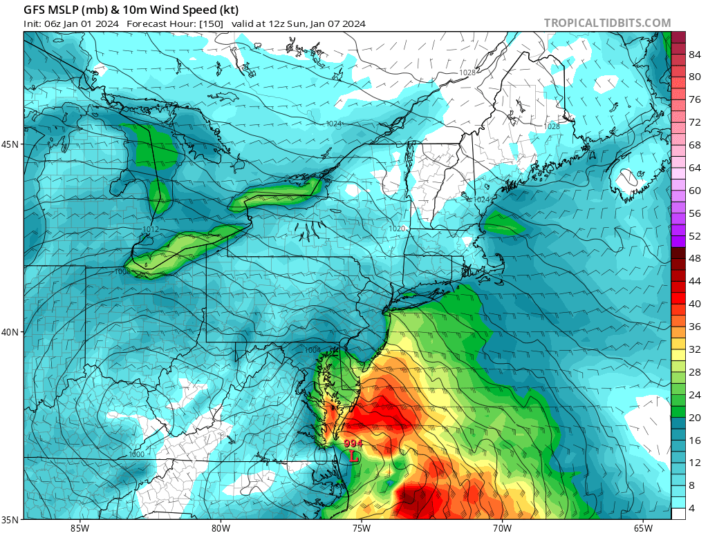
Two Mdt to high impact events NYC subforum; wknd Jan 6-7 Incl OBS, and mid week Jan 9-10 (incl OBS). Total water equiv by 00z/11 general 2", possibly 6" includes snow-ice mainly interior. RVR flood potential increases Jan 10 and beyond. Damaging wind.
jbenedet replied to wdrag's topic in New York City Metro
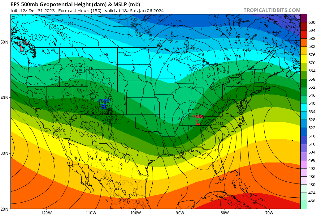
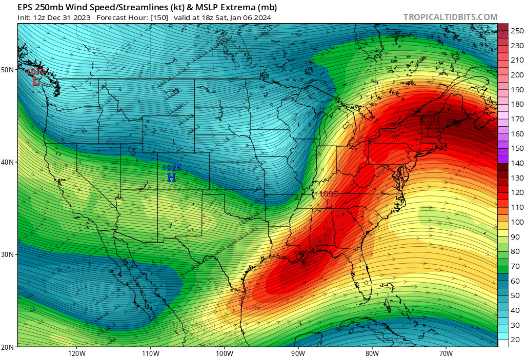
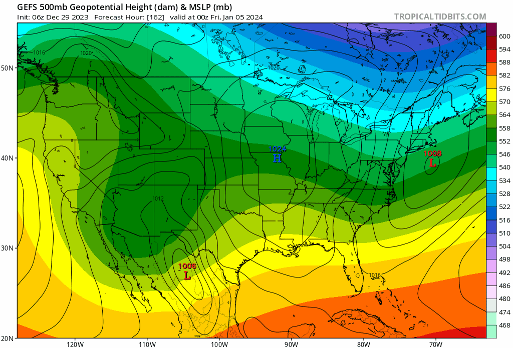
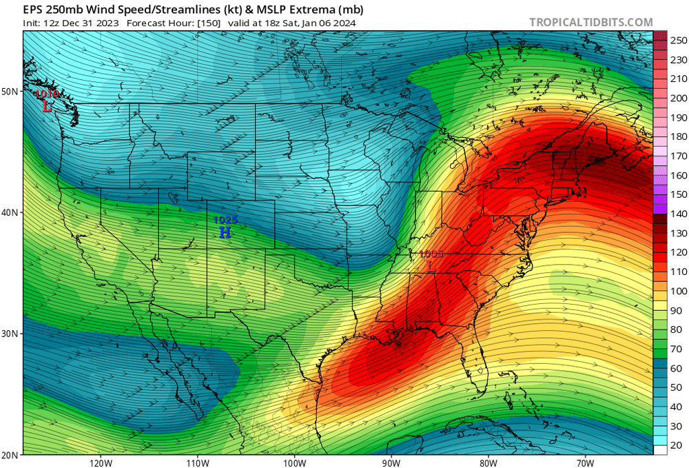
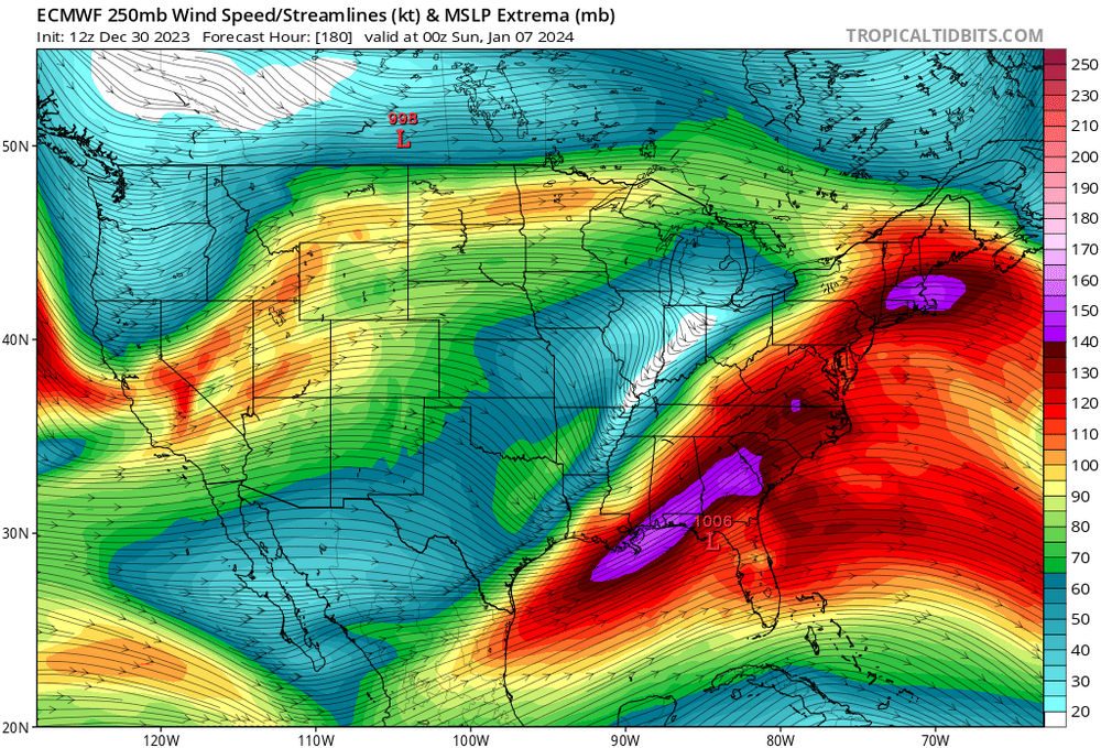
Pretty damn cool the way the pacific jet just amps up with time with such consistency. Check out the area in Northern Gulf of Mexico. Significant El Niño flexing. You see a firehouse pointed toward southeast Canada; that air coverages and sinks, filling our Canadian high with maritime tropical air. It doesn’t anchor and the depth of the cold weakens with time. It’s why a significant -NAO can get neutered with a deep trough in the west and El Niño background.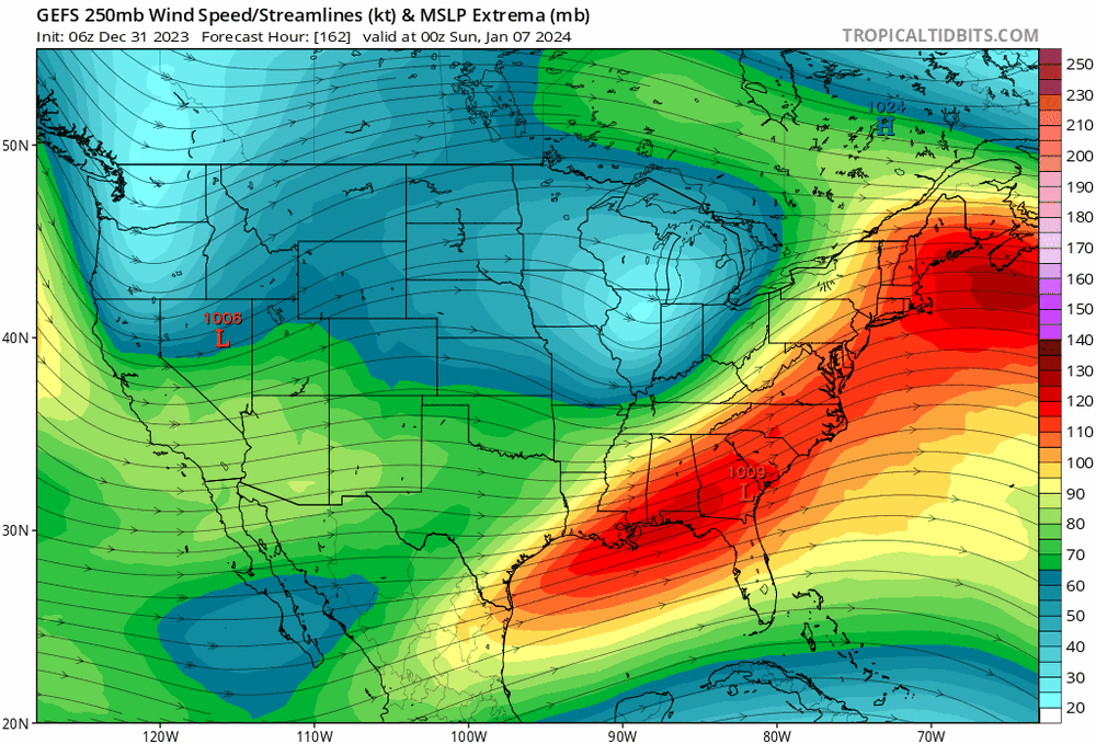
- 3,610 replies
-
- 8
-

-

-
- snow
- heavy rain
- (and 5 more)
-
Two Mdt to high impact events NYC subforum; wknd Jan 6-7 Incl OBS, and mid week Jan 9-10 (incl OBS). Total water equiv by 00z/11 general 2", possibly 6" includes snow-ice mainly interior. RVR flood potential increases Jan 10 and beyond. Damaging wind.
jbenedet replied to wdrag's topic in New York City Metro
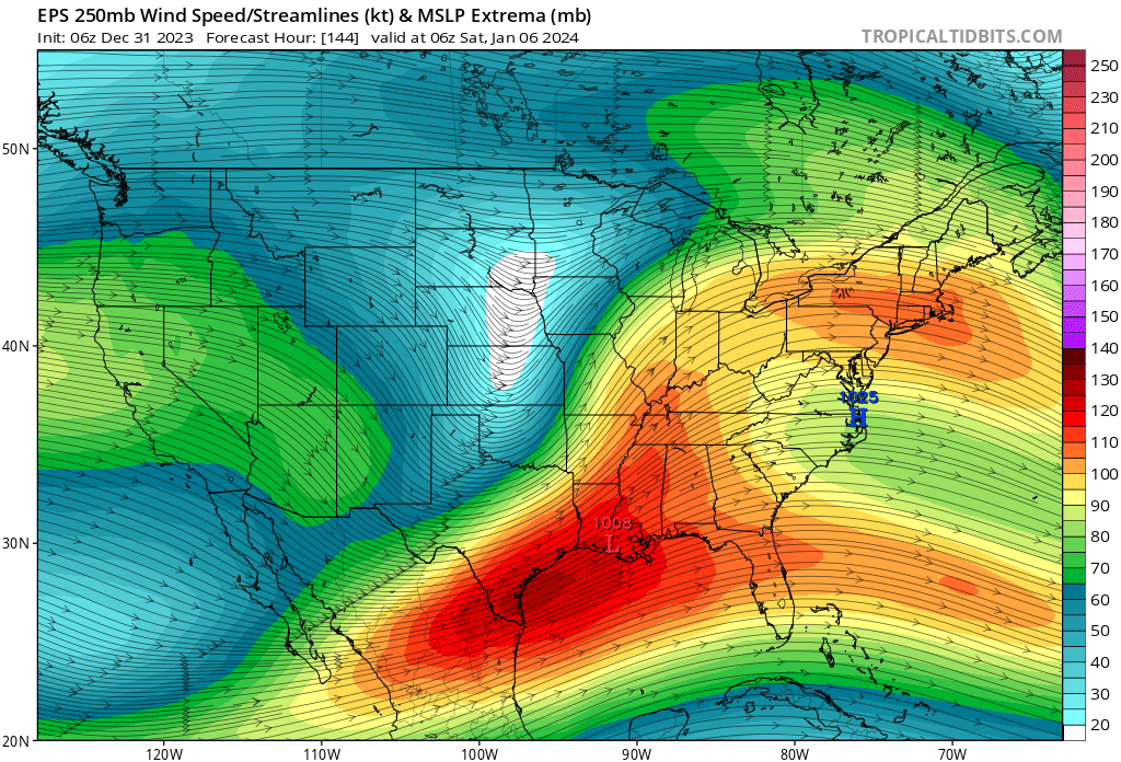
GEFS is south. Bigger point is the way the surface high becomes one extended all the way to Bermuda. That’s a “too warm” problem for all densely populated locations along the coast. West is best.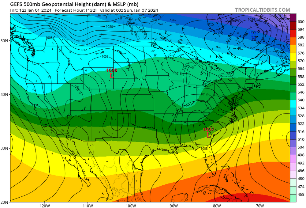
- 3,610 replies
-
- 1
-
-
- snow
- heavy rain
- (and 5 more)
-
Two Mdt to high impact events NYC subforum; wknd Jan 6-7 Incl OBS, and mid week Jan 9-10 (incl OBS). Total water equiv by 00z/11 general 2", possibly 6" includes snow-ice mainly interior. RVR flood potential increases Jan 10 and beyond. Damaging wind.
jbenedet replied to wdrag's topic in New York City Metro
I don’t look at the ICON, personally. i referenced the CMC only to see the “what if” such a scenario played out; albeit highly unlikely. I think the main takeaway is the significant snow totals look confined to a one region area, regardless of the evolution. It’s a fragile setup. -
Two Mdt to high impact events NYC subforum; wknd Jan 6-7 Incl OBS, and mid week Jan 9-10 (incl OBS). Total water equiv by 00z/11 general 2", possibly 6" includes snow-ice mainly interior. RVR flood potential increases Jan 10 and beyond. Damaging wind.
jbenedet replied to wdrag's topic in New York City Metro
Yea, this looks a lot more like a latitude capped storm—>early occlusion, with UL heights building over top of it due to trough in the pacific and then slide ENE. The 12z CMC does not make any sense to me; 12z GFS much closer to the actual evolution imo. -
Two Mdt to high impact events NYC subforum; wknd Jan 6-7 Incl OBS, and mid week Jan 9-10 (incl OBS). Total water equiv by 00z/11 general 2", possibly 6" includes snow-ice mainly interior. RVR flood potential increases Jan 10 and beyond. Damaging wind.
jbenedet replied to wdrag's topic in New York City Metro
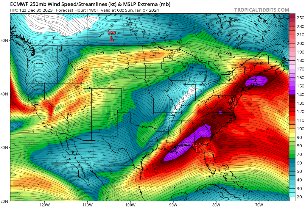
I’m def more in the camp that this is a mid Atlantic—>south snow storm at the moment. However there will be a significant longitudinal gradient. Where H5 closes off, in and away from the coast, sees the jack. The GFS track/evolution was near perfect for a significant mid Atlantic storm but look at the east surface winds ripping. And they never orient N/Northeast, instead to ENE. The surface high in reality extends from eastern Canada to Bermuda, and therefore maintains the surface wind direction off the Atlantic. This is being flagged on the ensembles, with +surface temp anomalies. Model guidance has consistently been too cold with very short lead times this season. It’s ridiculous that GFS has LI in low mid 30’s with this wind and SST’s in upper 40’s. It’s a major issue for NYC metro. Hell even BOS will be 40F with this look.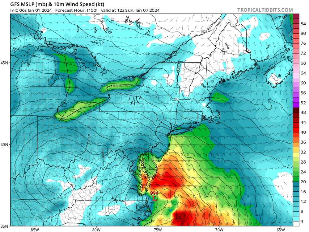
- 3,610 replies
-
- 6
-
-
-
- snow
- heavy rain
- (and 5 more)
-
There is no argument. You picked one map of two bc that fits your snow glass view. Talk to me about the EPS H5 and Pacific jet. Good luck. “See more snow” Yup. Got it.

-
Oh wait. Lemme get this straight—you were analyzing the output from one op run at day 8, and I’m the one grasping for straws with the EPS output. See more snow. Apt name. Accurate.
-
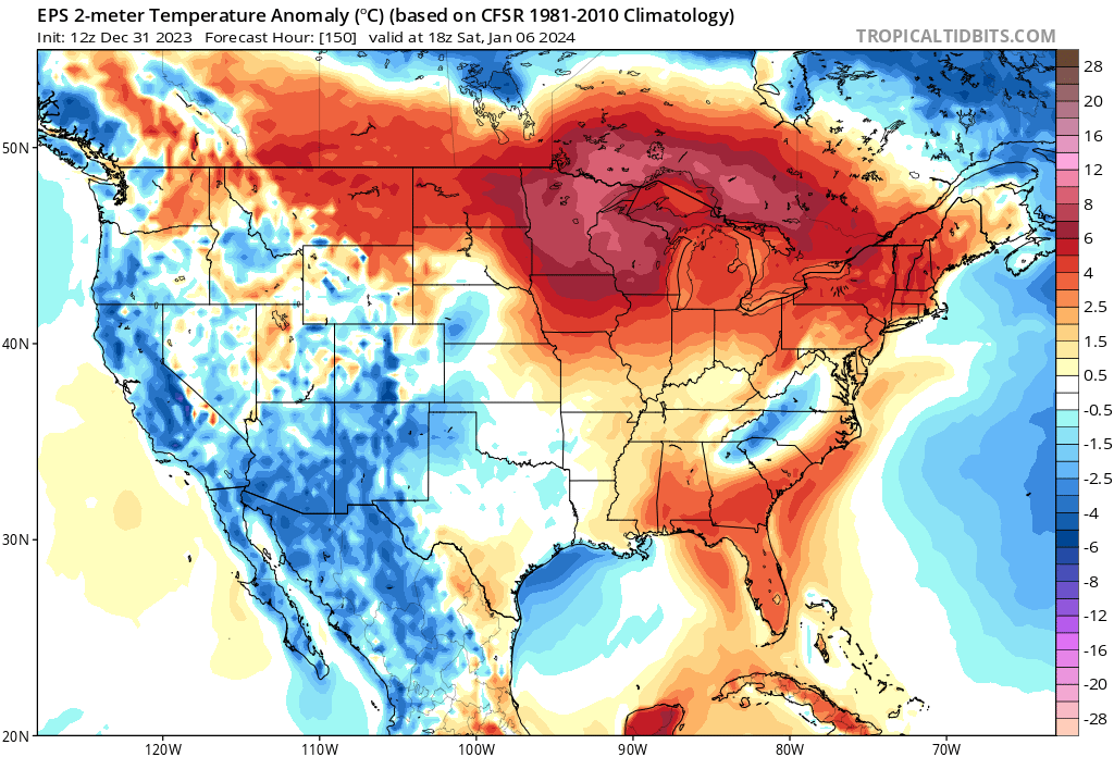
That’s 2m temp anoms. Thanks. We know. Your H5 is there also, because of that.
-
I believe you’re right on this. The pacific worsening as this is trying to get going is outweighing the northern stream improvements in the east.
-
And the weenies were rejoicing this morning on… who the eff knows. You know, you guys can run these loops too…Just sayin’. Hope springs eternal.

-
12z GEFS looks like dog shit for the 4th. Gone.
-
You guys read model output verbatim. Report on it. Thanks for the pbp. Cool. We all can read.
-
I think you can get an early phase; but it’s a mistake to extrapolate a further north track—it’s a cut-off slide ENE. Confluence over the western Atlantic.
-
That’s a robust -NAO turned to western Atlantic ridge for the 7th/8th. Thanks to the skunked pacific. -NAO be damned. Easterly flow, warm.
-
That’s close for areas like Richmond VA, up to ACY. 12 hours earlier phase. Boom. That region should be watching very closely.
-
“Ignoring”. Not the right choice of words chief. You lazy guys just need your daily dose of model crack to get through the day. Hope springs eternal.
-
Jan 4 is the big dog potential when the pacific isn’t skunked. It’s just too far south for us; save maybe extreme southern sections.
-
A whiff… And then a whiff or rain. Can’t wait.


-
Until the storm comes in, and with it the pacific air.
-
The serviceable airmass for 4/5 is gone by the 7th.
-
The 7th one is all but completely off the table. Even if the track somehow takes it north to our region, which is unlikely in and of itself, it will be flooded with tropical pacific air. Rain. Careful what you wish for. You guys…SMH
-
Laugh at what you want but these dumazz tik tokers would have had higher verification scores than most of the people in here —degrees and all—by studying effin’ wooly worms for 3 min. Yup that’s right, those big ugly hairy mfers crawling around your yard in late fall. But models… Sebastian Maniscalco voice: “Aren’t you embarrassed???”