jbenedet
-
Posts
6,963 -
Joined
-
Last visited
Content Type
Profiles
Blogs
Forums
American Weather
Media Demo
Store
Gallery
Everything posted by jbenedet
-
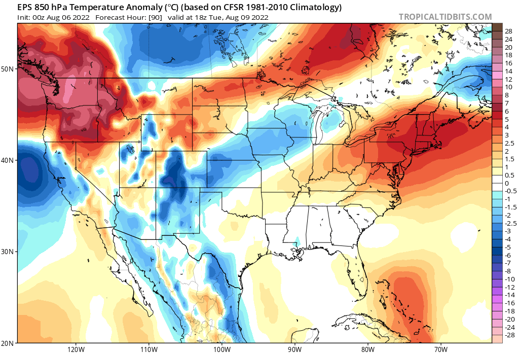
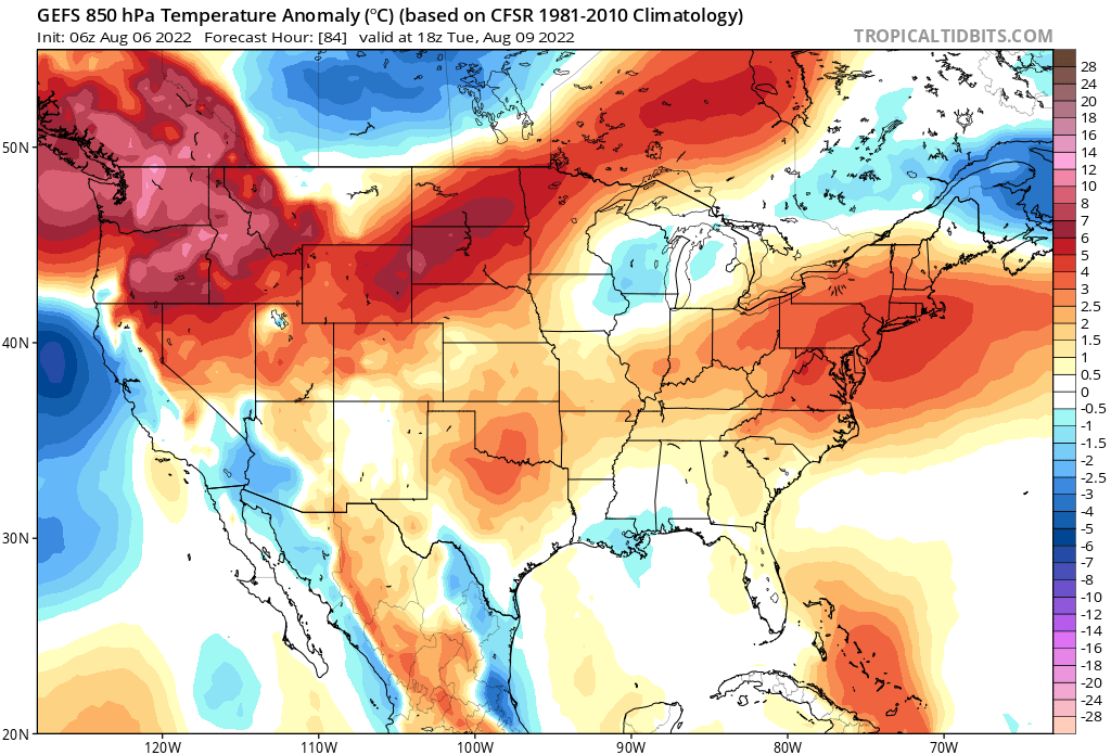
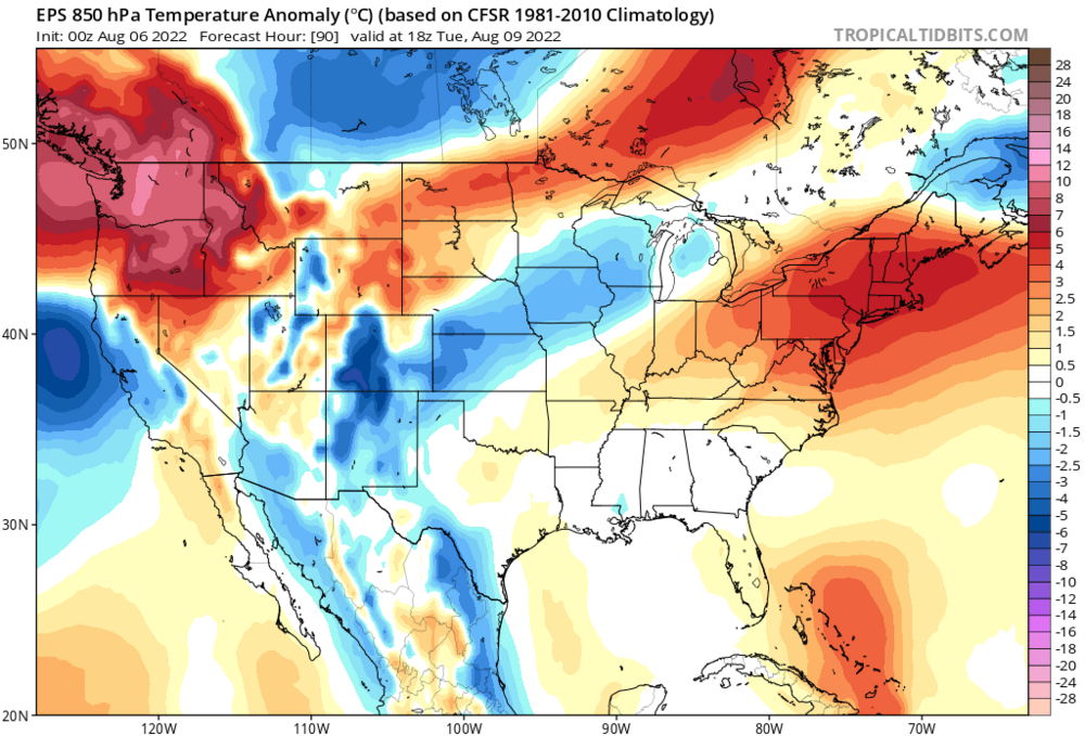
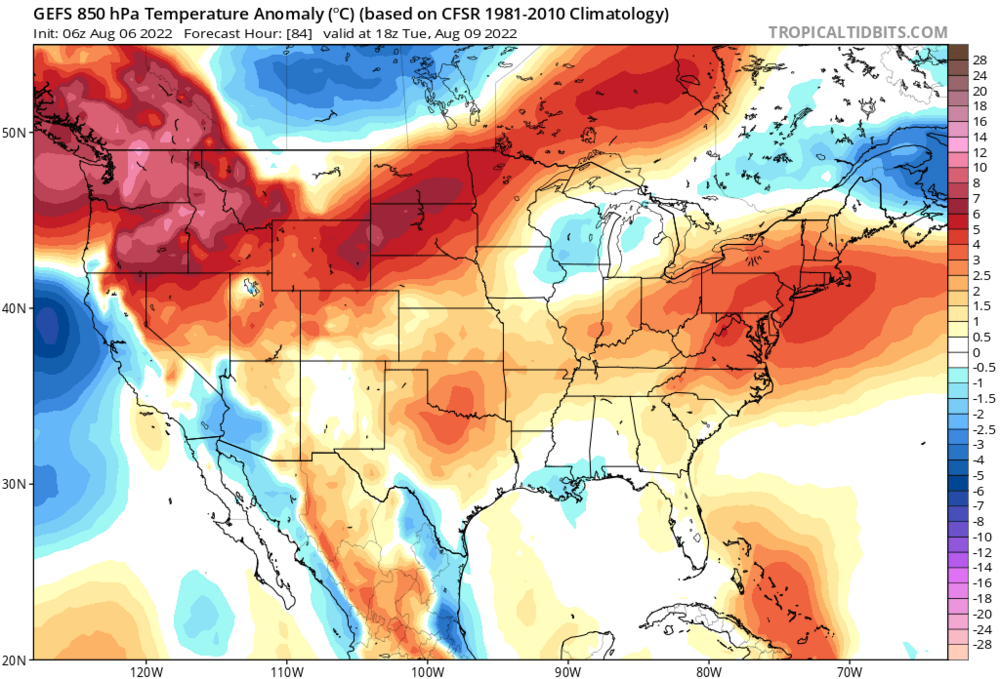
You guys are getting baited by the GFS on this BD. The GEFS shows a very weak signal until you get into Maine. And the last run was less a signal than the previous. The EPS is showing a torch, Region-wide. SELL. If you want to hedge, go Winne—north and east. The WAR is flexing. I believe Tuesday ends up another 95+er, my back yard included.
-
Aiming for legit desert climate to New England before it breaks I guess. It's been boring, might as well get something "extreme". I guess.
-
Outside of Maine, and Winne North, I say sell the BD. Looks like 90+ every day here through at least Tues. Brutal. Not even my hot weather plants like this shit.
-
I believe the persistence long term trend in the northeast has been more of an east vs. west rather than north vs south. Worst conditions, east. Last year Maine was hardest hit, percentage wise.
-
Data Tables | U.S. Drought Monitor (unl.edu) Last year peaked at 4% of NH in Severe. There were water restrictions in Dover last year. 2021-07-20 47.51 52.49 19.94 3.03 0.00 0.00 75 2021-07-13 39.98 60.02 30.58 3.92 0.00 0.00 95 2021-07-06 10.39 89.61 57.07 3.93 0.00 0.00 151 2021-06-29 9.75 90.25 58.47 3.93 0.00 0.00 153
-
Pretty sure this is the 3rd consecutive summer I've hit severe drought conditions. Maybe 4th.
-
We severe. Drought. Drought. Let it all out. These are the things I can do without. C’mon. https://droughtmonitor.unl.edu/CurrentMap/StateDroughtMonitor.aspx?Northeast
-
Right. “Before” as in last week, and the week before that and the week before that…
-
Said like a real politician
-
Barring tropical threats, this upcoming H5 pattern looks like the warmest and driest yet. Really hoping to score a t-storm or two before this locks in. Looks like our best chance at drought ending rains will be all at once (be careful what you wish for), bc baroclincity will be confined to Canada.
-
Usually the yin and yang of anomalies is visible by just zooming out to the CONUS—east vs west, north vs south. But it appears the whole of the Western Hemisphere is significantly drier than normal, and has been this way for a few months. Hell, we here in New England have managed severe drought conditions with persistent eastern CONUS UL troughing.
-
I’ve had a lot of success growing fruit/vegetables in drought. Sunlight difficult/expensive to harvest. Easy to collect enough rain water through persistent moderate to severe drought conditions once you have a system setup. My yields would be a lot lower with excess rain in summer, no doubt…
-
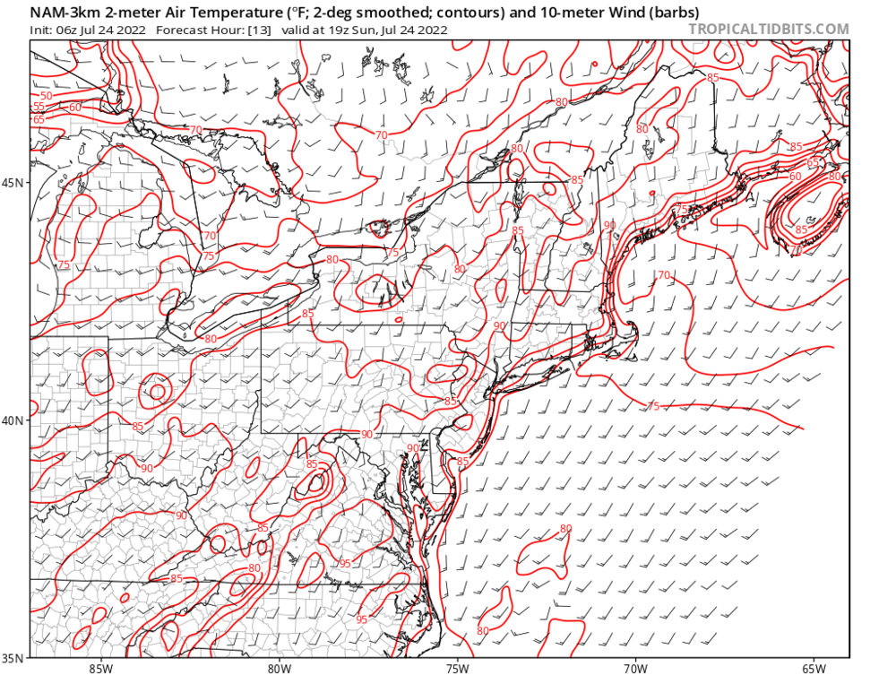
60+ dews throughout. And ~65 as a mean throughout the 6 day stretch. This wasn’t a dry heat. Period. Not my opinion either—the dews were *additive* to the Heat Index. So this idea of a dry heat is a non-starter. 55 or less sure. Otherwise it’s a tenuous point, objectively and subjectively.
-
DAW 6 day stretch. 95, 95, 95, 93, 96, 99
-
You live close enough. Go take a drive and a reliable thermometer. We are cooked.
-
I counted 6 days out of 23 for DAW, 4 out of 23 for SFM. Far from most. Bulk of which coincided with the heatwave. And isn’t that exactly what you’d expect in a +3SD airmass? I think there’s an enhanced ageo flow due to mesoscale coastal front, max surface delta t/delta n, sets up regularly right along NH coast, where the Labrador current meets a cooked tropical airmass.
-
Quite the seasonal extremes here. It’s like flip extreme CAD tendencies in February from DAW to EWR, and call it WAD in July, and instead of the airmass advecting down the Apps from DAW to EWR it’s up the Apps from EWR to DAW. You can see even global guidance picks this up regularly with the mesoscale WAD 75 miles into York County Maine.
-
Most of SE NH is in severe drought conditions now. Barring low chance of widespread heavy thunderstorms, Monday night, this will be reflected on next CPC update.
-
This is the hottest stretch in memory since I moved here June 2015.
-
Rochester New Hampshire past 5 days, with dews 60+ throughout. 95, 95, 95, 93, 96, And today will be the hottest.
-

Severe Weather Threat Week...so many threats!!!
jbenedet replied to weatherwiz's topic in New England
Ooof. That's a plant flattener at the peak of the season. Cool to experience but a hard pass, especially in late July. Whatever gardeners/farmers were in the way of this are now looking to next season. I'll gladly take my drought. -
In spring to early summer maybe. But fall and winter seems among the fastest. Averaging it, over course of a year we are among the fastest. What’s really interesting is we are at the tail of a cold water current, from the Arctic, whereas the UK is at the tail of a warm water tropical current. The UK has been seeing significantly warmer summers (++AN) but cold winters (N to AN); we have been seeing significantly warmer fall and winters (++AN) with warm summers (N to AN). The causality (net increase) is quite similar, but the seasonality is flipped. There may be a cogent physical explanation for this…
-
The Gulf Stream must be cooking. You'd think coastal fronts would have capped temps all over the UK long before they got near those temps. The UK is ground zero for greatest rate of climate change - High latitude + surrounded by water + Gulf Stream.
-
Agree for sensible weather, but it's a terrible trade-off for the vegetable gardens. As I've increasingly taken up gardening my likening to weather has shifted to "what's best for the plants".
-
Warm front showers and then....? Meh... If we could lose the clouds after the warm front it would be game on, but I'm very skeptical of that, especially in SE NH. Southerly fetch also gets tainted by marine layer in eastern areas. I like central western MA and central/western CT for severe chances--warm front clears early and looks like good chance sky clears to destabilize things.