jbenedet
-
Posts
6,963 -
Joined
-
Last visited
Content Type
Profiles
Blogs
Forums
American Weather
Media Demo
Store
Gallery
Everything posted by jbenedet
-
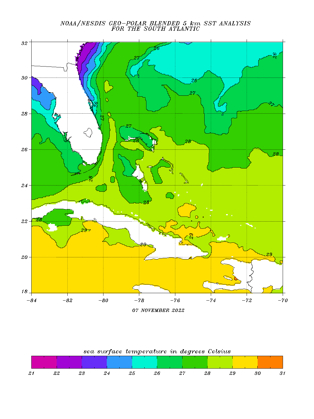
There was a relatively cool eddy Nicole passed over yesterday evening - 26-27c isotherm. My thinking is this was a big contributor to rapid warming of the convection. And that’s been validated by the big changes today while atmospheric conditions are largely the same.

-
Already has the look of a high end TS/marginal hurricane 65-75 mph status.
-
Nicole looks a lot healthier than I expected at this hour. Guidance is going to have to ramp up the intensity forecasts today to regain reality.
-
I don't get the early recurve scenario - with most major guidance (ex the 6z GFS) showing a sig northern component returning to Nicole's trajectory while the UL trough axis is still over the Rockies. 6z GFS makes the most sense to me (by far). But still think it's slightly too far north across Florida. I don't think we see any notable latitude gains until Nicole is in the Gulf. The whole scenario is evolving for a more impactful evolution-- a second landfall, then up the eastern apps into New England, as it phases and becomes extratropical, begins deepening.
-
^That's a solid forecast at this hour.
-
The lack of weakening advertised on the 6z GFS as storm traverses Florida is insightful - to my mind it points to storm entering most conducive environment to strengthening right as it nears landfall. We need to watch this aspect closely - track at landfall we are zeroing in on, but intensity looks like a big question mark. I believe we could see big shifts in this regard inside 24 hours The track further south also means more time over warmer water. Being November 7, 100 miles means a lot in terms of SST's even off the southeast coast of Florida.
-
Bit by the devil yesterday. Remember remember the 6th of November. First tick bite ever in mid fall. Didn’t even leave the suburbs of the Seacoast yesterday. So keep your guards up folks.
-
Given the unusually strong nature of the H5 ridge, I believe this TC will make a b-line for southeast Florida without much of any shift in trajectory. I think the speed it tracks to that point will also surprise to the upside —18-20 mph. The uncertainty is highest with what happens after, as recurve begins.
-
The +3SD H5 Ridge that builds over the eastern CONUS going to keep this south, with a west heading, Miami dade county to keys looks most interesting, then into the gulf before next H5 trough picks it up north. GEFS and EPS in strong agreement on this, general outcome. Sell the other guidance tracking this north into the SE coast.
-
The weather pattern over the eastern CONUS over the next 7 days looks like it will be way above normal for early November. The tenor will look more like early October. As a result, I say whatever does develop has a much higher chance of being purely tropical.
-
Just stare at the models. They have all the answers. Meteorology deserves a lot more respect than economics as a field of study. We have ourselves to blame.
-
People forecasting the next cold snap before we have even seen the depths of the warm-up. Pull out the darts. Sorry guys, however much you want to believe the screen-- it's not that good; not even close.
-
Looks like we'll top high temp guidance by 12.
-
This is awesome.
-
I really do hope this is pushed out into the future as far as possible. I love a good storm as much as anyone, but I’m very sympathetic to people who will be unable to heat their homes for no cause of their own. heating oil up 75% vs this time last year. Pretty much anyone in the middle class is seeing their after tax raise get wiped out by this.
-
I take a moped into work on dry days. Wife and I sold one car when she landed a good work from home job, and used car prices went bananas. Easiest big sale transaction ever. Had a bunch of skeptics at work back in April when I first picked it up as to how practical it was. Well here we are in mowvember and I’ll be riding it in every day this week. I agree with Tip, everything looks like 70+ this week, away from the water and mountains.
-
Man if we could break into sun today.... 68/66 at Islip Long Island.
-
Our falls are much better than our springs. So much so that I'd take November's weather over May's, and that's especially true through mid Nov/May. Climo and event planners would strongly say otherwise though.
-
Planning a trip with friends to the Berks mid January. Any tips on best towns/cities to check out or stay closest to?
-
Guidance trying to spin up a weak surface low around Florida, Friday. Looks STCish. The WAR pumps so whatever does develop will ride up the coast. Something to watch with mild interest.
-
Preliminary property damage estimates for Ian so far range from $42 billion to as much as $258 billion, with some landing in the middle. https://www.route-fifty.com/management/2022/10/how-costs-disasters-hurricane-ian-are-calculated-and-why-it-takes-so-long-add-them/378465/
-
Last night was very mehh... But the wind was always set to come at the end, which is showing up nicely. 43 kts sustained headed up to Portland ME. NDBC - Station IOSN3 Recent Data (noaa.gov)
-
Regional max looks like Portland Maine.
-
I get the technicalities. 99% of the people who will be affected don't know or care. That's all I'm saying. Go tell your neighbor about the mesolow coming up the coast and watch for that dear in headlights reaction. And for the NHC it's the 99% they are measured by, whether their warnings were adequate. They ultimately need to hedge forecast risk against sensible weather outcomes; not technical definitions. Eh. Whatever.
-
Will see. Could be full of it. But some of these rapidly ejecting NE/ENE nascent Tropical lows are so strange. Strong UL divergence trumps all factors, at times, I guess. You'll see them spin-up in no time in the middle of marginal conditions and yet ideal conditions in the Caribbean it takes 3 days for the same stage of LLC development.