jbenedet
-
Posts
6,963 -
Joined
-
Last visited
Content Type
Profiles
Blogs
Forums
American Weather
Media Demo
Store
Gallery
Everything posted by jbenedet
-
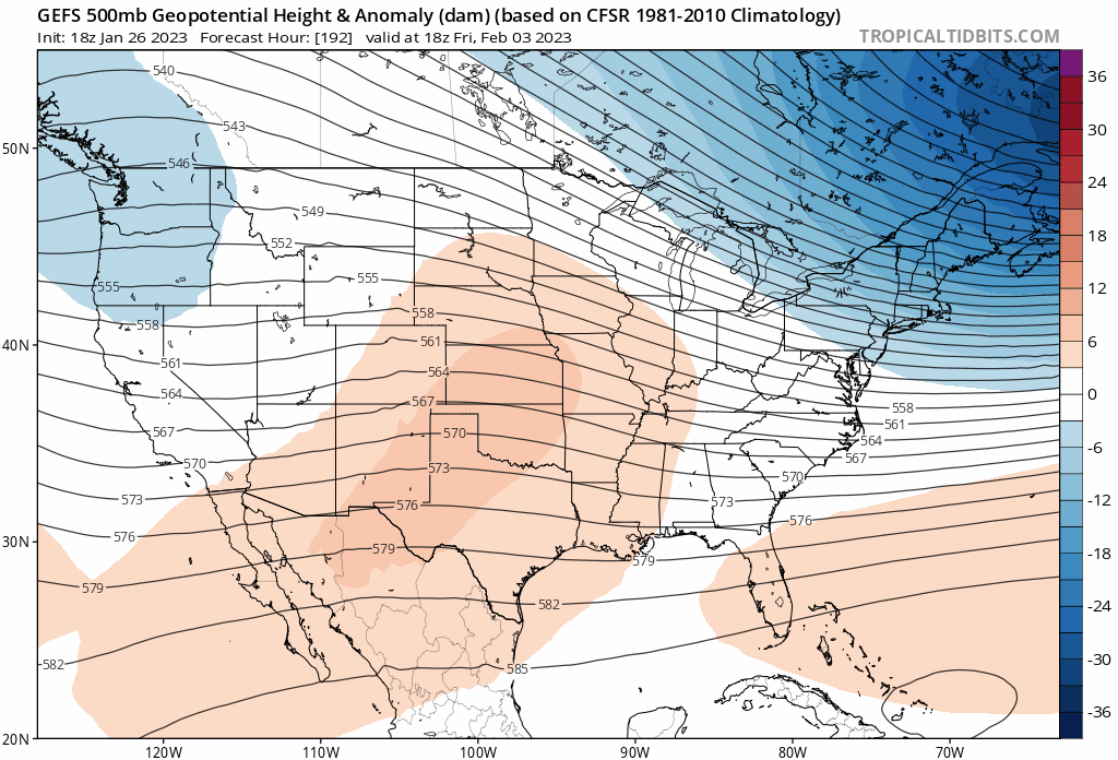
You’re in NYC. I think you misunderstood the takeaway. If things trend flatter in the eastern CONUS, the SE ridge would be helping you with the day 6 threat in terms of snow chances. But cap expectations under SECS. It’s not a suppressed look, more flat and progressive. My early take is this looks like a ribbon of snow broad, 4-8” 6-10” narrow; Indiana-Ohio to Northern Mid Atlantic. Open wave, traversing a North/south oriented frontal boundary
-
I mean, next week is looking more flat and progressive than suppressed due to confluence. If the shortwave in the southwest stays south it’s more because the southern stream is unlikely to hook up with the northern stream; and gain little latitude. This disturbance cuts off at H5 over California by the way. Not exactly a good start to pumping heights. The H5 look is messy; disjointed. Unsynchronized.
-
Looks like clipper potential. Doesn’t look exciting to me at all. I don’t think you’re too far north; you’re actually in a good spot to add a little to the pack looking out over next 7 days.
-
We’re losing the cold shot in early February as the SE ridge is doing what it’s been doing all season. Looks to be evolving into a more zonal look. Good news is suppression is off the table. Arctic cold with no snow is the worst.

-
Renting is under-rated around here, if you're smart. Property taxes + maintenance costs can easily surpass rent, with the right setup. That's not a loss in equity. And invest your money elsewhere. Also there's a lot of dumb landlords with much more money than sense. Get into it without knowing basic finance.
-
41/39 We melt
-
I'm expecting to lose the entire pack over the next week, save the piles.
-
Let the thaw commence
-
I get it. But we’re also heading right back into a pattern that looks especially torchy. So bias it tilted heavily AN and temps busting low for next 10 days.
-
meh. I didn’t do anything for my driveway. It’s a mess right now, but still have 40’s and sun the rest of today. The damage to the packs happens from here to sunset. And with what’s left, highs tomorrow will be mid 30’s and presuming your driveway is not in full shade, the sun will do a lot of work with that.
-
Show me the roads!
-
It seems like splitting hairs, but it's far from it. I'm a split between DAW and PSM, all year round. Take the obs in each and average them. That's Dovah.
-
DAW is north of CON. So as I said they could see 3" They are 10 miles northwest of me, and CAD on Maine Moose farts. Further from coastal plain. Dover 1" is still my guess.
-
But Wind: SE 9 I would never get out early for something like this. Not even close. There's better than even odds the roads are just wet in SW CT. The high sensitivity to this stuff assumes every parent has a full time remote job. Must be really tough for the families who don't.
-
Sell this fast. Early precip looks like weak overrunning warm front. Poor airmass, weak storm. Not much in the way of isentropic lift. Also, I see east winds keeping temps/dews >32 from eastern SNE up to coastal York ME. Sell any 3"+ amounts south of Concord NH. 1" for my hood, is my guess, before the flip.
-
 Yea timing was poor in both directions. Precip moved in after sunset last night but 850-925 was the main problem. Now 850-925 cool enough for snow, but best snows move in with crap airmass in early afternoon. A lot of 32.5 - 34.0 snow to fall which doesn't stack well without rates; and a 990 mb low doesn't get me excited about the rate potential.
 -
I just came back from a trip out to the Berks - Lee, Great Barrington area. Saw 24 hours of light to mod snow amount to less than an inch. Been a similar story back in Dover. Interior or not, it's BL temps have been a major problem throughout SNE. People in this area are not used to being laser focused on BL temps. Growing up on LI you lived and died by it for snow total accums. This year in SNE tracking BL temps >> tracking radar. The former has been the problem, while the latter has been outperforming.
-
I mean…very marginally. But you are going to lose a lot in terms of poor ratios vs those clown maps.
-
Common theme this year, in SNE and my hood is that when 850 is no Longer a problem; the BL is. There is no cold on the back side of this. Period. It’ll flip back to snow, and most will see quite a bit falling, but a lot of it gonna go down as white rain. 1) Sell the clowns. 2)Hedge with 5:1 in the colder spots. 3)Don’t believe it until you see it at the stake everywhere else
-
Yea that was the warmest run yet. Looks like a lot of liquid here. Shocker. Somewhere around DAW—>Hookset going to get all frozen on those caked trees though. Heavy wet snow/ice, throughout right where that 850 0c line makes its furthest progress north. Outages no doubt. They can keep it.
-
Freezing drizzle. If this stays frozen, setting up for a serious cluster with the way the trees are caked with snow from 3 days ago. There’s a large swath from PSM-DAW, southwest down to just north of ORH that have trees full of wet snow; and those same areas looking at ice/very wet snow. Yikes.
-
We’ve seen a lot of long duration events this season and this one also fits the bill with all the UL energy hanging back. So the Friday story is real but will probably be more mood-influencing than of substance with rates/temps that don’t allow it to stack up. Steady-state, “it’s beautiful/nice to see” vs I added another 3”. Type snow. The latter confined to higher elevations.
-
There’s also a needle thread option in areas in interior MA, that cold tuck well. Looks like the first wave of precip is out ahead of the warmest push at 850. There is “sweet spot” potential where surface is 32ish. Would see mostly snow, as 850 doesn’t warm >0C until it’s moving out/ending. Lose about 1/4 precip to sleet/ice at end. There’s a lull, and then Friday morning, part 2 all levels support…
-
Pretty surprised by the lack of cold in western and CNE. Was wrong about that. The areas on the margin yesterday now tilted towards much less, right around the pike. The NAM performed well.
-
It's gonna be a nowcast along that southern edge. We'll have a good idea which way it's gonna break depending on the morning dews in the region. Tough deal given the densely populated areas that fall along it--Boston, the suburbs ORH, etc. But it is what it is.