jbenedet
-
Posts
6,955 -
Joined
-
Last visited
Content Type
Profiles
Blogs
Forums
American Weather
Media Demo
Store
Gallery
Everything posted by jbenedet
-
March sun for the win. up to 18 off a low of 3.
-
PSM 27
-
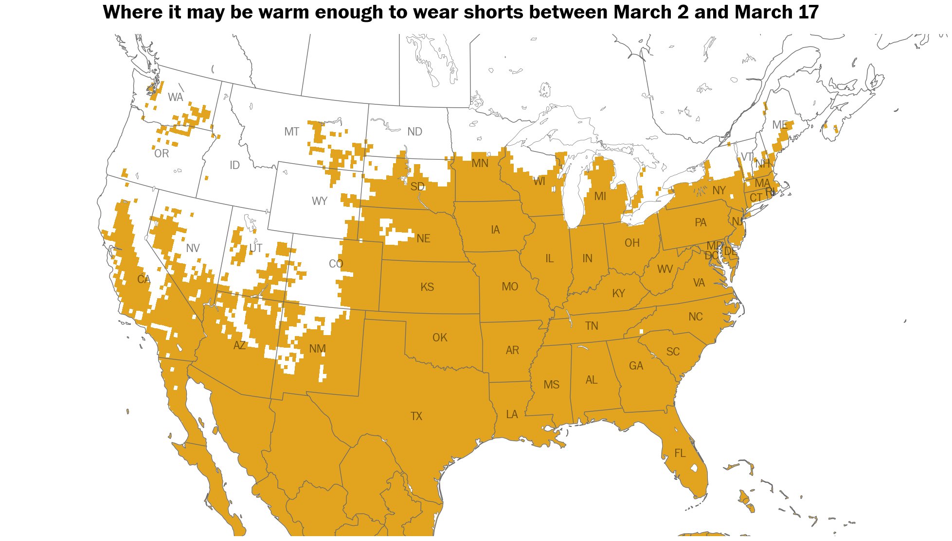
This is actually a really cool graphic in how it highlights that narrow stripe of climo warmth up into Maine. Need to be east of the Apps but away from the immediate shore. DAW happens to be right in there, along with my back yard. PSM and PWM are a lot cooler due to very cold gulf of Maine…this prevails most of the warm season months but is most pronounced from March to mid May

-
Funny how you guys start using DAW when it’s colder than seacoast. I thought DAW was broken? I’ll use current reliable obs. The Observation for Dover is consistent with the area. PSM is at 25 now. You can wait for the update every hour. I’m predicting the future I guess.
-
26/-2 I was mentally prepared for much worse so it’s a win…
-
50/36
-
45/32 and partial sun. What a beaut.
-
38/31 and sun coming out. Time to head out and enjoy this. 55F is in reach before we’re back in the freezer.
-
It’s pretty simple. Maybe your long term memory is shot? I had a 4” LE snow/ice pack a week ago. It will be bare ground by ~3/6. If I had average temperatures and even zero additional snowfall from here, it would take to end of the month or even to mid April to eliminate that pack. That’s common sense. Yea it’s been a big shift around here, especially vs the Jan/feb temperatures we’ve seen. It’s noteworthy.
-
Looks like the pack line will be wiped back to its traditional stronghold just north of DAW/PWM/MHT line this Thursday.
-
36/29 already. Torch incoming.
-
Every day this week was AN. This week did a lot to balance out the solid negative departures observed the first 3 weeks of the month. I’m thinking imby, this will come in very close to normal; strikingly similar to January.
-
Tomorrow has a solid torch look ahead of the cold front. +15 is in view for good chunk of eastern SNE up to seacoast NH. mid 50’s incoming.
-
Birds chirpin’ 38F, calm wind bright sun at 8 a.m. Great morning dog walk vibes.
-
The pack loss has been substantial in terms of LE. I’m down to about 2” LE vs 4” at the start of the week. The ground also completely thawed in most places with decent sun exposure. Last night was third consecutive with temps >32. Temp back up to 35 and with full March sun the pack will be on retreat through tomorrow evening, before we go back in the freezer for a few days. Again, this week was a godsend to essentially eliminate fresh water flooding risks around here.
-
I’m done with this crap. White rain storm here. Looks like dusting at best and only in colder spots. now up to 35F.
-
Probably not. But you guys are also more resistant to this risk, because it happens more often. Around here on the seacoast, the pack is taking a beating 52F with partial sun, and it will continue through tomorrow. No refreeze tonight either.
-
I'm just feeling really grateful we are having this warmup prior to any major rainfalls. We were seriously primed for hydrological issues with the frozen ground and large/dense pack of snow and ice. Roofs were saved too. More snow and ice on top of what we had would have really stressed out some structures in my area. We dodged a major bullet in both directions.
-
Today through tomorrow should be a big ice killer with overnight temps staying above freezing and then rising to near 50. Break out the steel shovels...
-
In SNH we should get a nice sun-induced spike in temp after these low clouds pull north, and before the higher level clouds roll in from the west. Timing looks good for 12-1 ish...
-
The long wave pattern has persistently sucked for coastals; I think that was something that could be picked up on early, and used to forecast BN snowfall in the warmer climate zones of New England despite the clearer indications of persistent cold.
-
There is less than a week left in February by this weekend guys…when MJO settles in phase 1…The sun is as predictable as it gets in this space—I’ll go with March vs February here… I’d check myself if the teles were saying otherwise, but as I stated above they are saying the same thing…
-
I am using FMA, especially as we will be into late February at this timeframe. Probability isn’t high, so I amend that statement—more like better than equal odds of AN but high significance… Fits with @CoastalWx narrative of warm sectoring with storms and useless cold behind. I’m seeing similar. The AN’s in the warm sector will be widespread and much bigger than the BN’s behind…
-
Run with the EPS guidance; sell the GEFS. Seeing MJO to phase 1 within a few days across all reliable guidance, and a likely stall here. Phase 1 is high probs AN in the northeast in February…This is especially the case close to the coast. WAR flex incoming. The GEFS guidance for the NAO/AO teleconnections is also indicating AN is arriving by this weekend…spikes in both indices… Next storms we will very likely be on the warm side of; I’m really hoping this comes with some gradualness or we risk flooding.
-
I’ll continue to use the most recent obs, for when things are rapidly changing. Thanks.