

jbenedet
-
Posts
6,955 -
Joined
-
Last visited
Content Type
Profiles
Blogs
Forums
American Weather
Media Demo
Store
Gallery
Everything posted by jbenedet
-
We should get it today. Would be a damn shame if we don’t given how much we’ve been above the min criteria.
-
No kiddin’. Lately we’re getting far interior southeast summer but New England early spring and crap weather through winter. I’ll take the southeast summer if I can get better springs and winters.
-
Speaking for southern NH, 90F air temp is such a low bar in summer now, I'd take the other side of any bet going against more heatwaves after next week. We've been running this heatwave with extreme dews... We can very easily achieve 90+ with "seasonal" airmasses by shaving 15 off recent DP's.
-
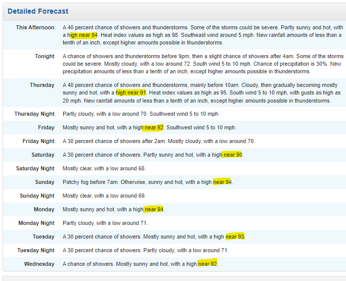
NWS forecast for DAW has 90+ on the table through next Wednesday. Wow...
-
Day 6 90+ Latest guidance consensus is Thurs and Friday will also continue the streak...
-
Little Lemon off the southeast coast. 10% probs at 5 days... BUT this thing--whatever comes of it-- is headed to our region by this weekend... so we track...
-
Guy in my town who refurbishes old AC's spotted with new mercedes van in driveway.
-
Local air conditioning businesses booming...
-
Thinking more on this - I wonder how many of those streaks came with days of <60F dews and <65F night time temps. My guess is most, if not all. If you'd don't catch my drift, I'd gladly take that 2002 90F streak, vs today's. Today's morning low....76!
-
10 day record is def doable here. I'm seeing the weekend with 90's on the global ops as well. We will def need some luck on timing for showers Thurs/Friday. That's the risk... The 6z euro op gives us that luck though... If we get that, could pull this out through next Tuesday before ending the streak...
-
6z euro has me hitting 90+ Wed, thurs, and Friday as well. 8 day streak 90+...? Would think that's a record in these pahts.
-
5th day of 90+ air temp in a row. Heat Index already hit 100. Did it with the clouds too.
-
Novel idea: grab yourself a reliable thermometer and drive 15 miles to DAW.
-
Heat index hit 99 at DAW. Last 4 days heat index: 99 96 102 99 It’s not all dews either. Each day air temp was at or above 90. Average high is 80. And tomorrow, heat index will exceed 100 and air temp >90.
-
Last thing I would do is reference the growing zones to track this warming. November warmth hasn't helped us, as sun angle is prohibitive by November 13th or so. That's latitude dependent. And our climate has been most "normal" in early to mid spring, which means the frosts are common through end of april. We've warmed up a lot, but I'm still gardening like a New Englander...
-
This is how it things are trending climate wise imby. It’s an ugly combination for sure; -New Jersey climo November - mid March -Southern New England Climo late March to May -Far interior sections of southeast climo: June to October
-
 Can see a CDO wrapping around the center of circulation and losing the pocketed/banded/feathered look it had all day. Expecting a big improvement in structural appearance over next few hours.
 -
Beryl is forecasted only 12 hours over the Yucatán which—to begin with— historically isn’t inhospitable to tropical cyclones. Atmospheric conditions are also tilted to favorable at that time. If core is anything like today, upon landfall, I believe odds strongly favor hurricane status vs tropical storm upon entry into the GOM.
-
Clouds will be problematic despite the occasional breaks. The breaks, in part, will lead to more clouds..then break…rinse repeat..I was in full sun up until a half hour ago. Now mostly cloudy. The real sky clearing line looks like it’s in Berks/VT
-
Every model has clouds sticking around in eastern sections. Caps the t-storm threat to strong to isolated severe. Gotta be west of 395 I think to get good clearing chances. The clouds were my high probability bet when I paid up for sox tickets. Not going if I’m going to cook in full sun and a soup airmass…
-
Who’s down in Great Bay area?That cell missed me to the south by like 3miles.
-
Man that southern cell when it gets toward coastal plain should be really interesting. No mountain disruptions on the Great Bay….
-
Yea this looks like a good show incoming. buckle up. Been a year for severe. Not expecting a fizzle upon closest approach.
-
The natural disaster risk that has increased the most around here in recent years is fresh water flooding. That’s something worth worrying about… Forget the tornado, worry about the rain that’s coming with the spin-up.
-
On vis satellite the structure of the cell heading for Manchester appears to be improving…Getting those overshoots into the stratosphere.


