jbenedet
-
Posts
6,955 -
Joined
-
Last visited
Content Type
Profiles
Blogs
Forums
American Weather
Media Demo
Store
Gallery
Everything posted by jbenedet
-
The fast track is misleading to fresh water flooding risks. The heavy rain starts tomorrow in Florida panhandle and doesn’t stop for 30 hrs. The interaction with the strong ULL will enhance and prolong the rains, as if this was actually a slow mover. Regardless of exact landfall I think Tallahassee is in an especially vulnerable spot in this regard.
-

2024 Atlantic Hurricane Season
jbenedet replied to Stormchaserchuck1's topic in Tropical Headquarters
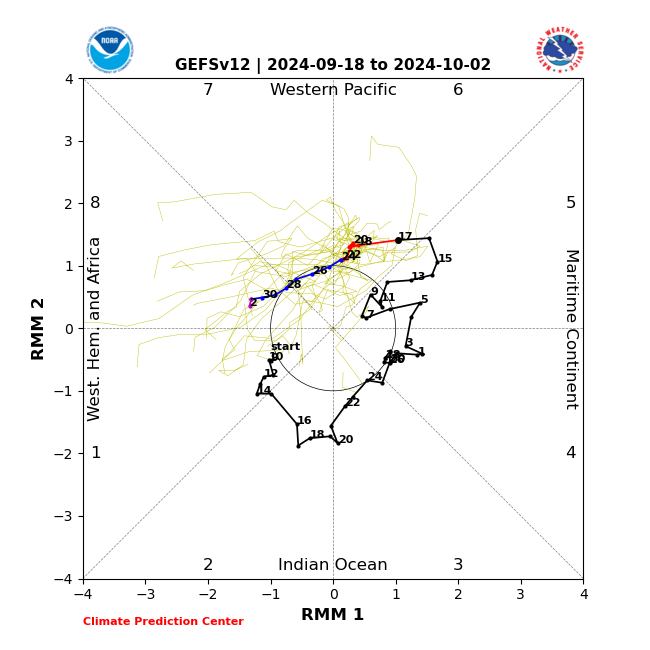
Having the repeat signals from the EPS and GEFS run after run is —as many have already stated—as strong an indication as any at this lead time that a strong tropical system is likely to develop. And then we have the MJO transition phase 6 to 7/8. The high amplitude troughiness seen across the central/Eastern CONUS on some of the op runs around the time of interest is much more likely than not…
-
Potential Tropical Cyclone Eight—50mph/1006mb
jbenedet replied to WxWatcher007's topic in Tropical Headquarters
I feel like NHC just complicates the warning and watch situation by not upgrading marginal calls like this. I.e. they make their job a lot harder. -
Potential Tropical Cyclone Eight—50mph/1006mb
jbenedet replied to WxWatcher007's topic in Tropical Headquarters
Should have a designation based on radar and satellite. TD or weak STC. -
Potential Tropical Cyclone Eight—50mph/1006mb
jbenedet replied to WxWatcher007's topic in Tropical Headquarters
All the NAM caveats apply but this is a synoptic gradient event if it materializes. Currently, highest prob is a sub tropical system, More persistent easterly gales, higher surge and higher surface winds than what the min surface pressure implies is what to expect.
-
2024 Atlantic Hurricane Season
jbenedet replied to Stormchaserchuck1's topic in Tropical Headquarters
Kind of funny reading through these comments while the op GFS is showing run after run of a land falling TC/STC in the Carolina’s within D4. But zzzzzz away….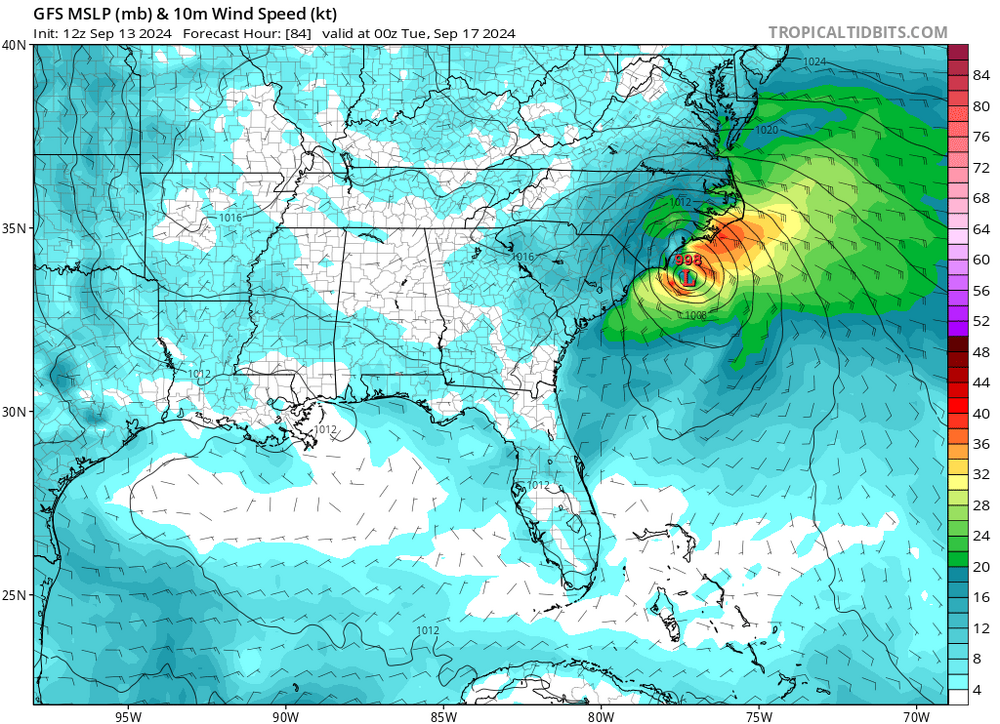
-
The impending shear impacts are mitigated due to storm relative motion. As long as Francene maintains a significant easterly component to track, that should maintain the case--more or less steady state in terms of surface pressure. I believe the weakening will coincide with the forecasted northerly recurve. The key of course, is when that exactly occurs, before or after landfall...
-
I’m much more interested in storm size at this point. If I had to guess, Francine looks more like a mid to high end cat 2 in terms of ACE. Anyone got those exact numbers to share?
-
Wind…who cares…? All about surge. Yea…even in a cat 1 in this part of the world…Modest 3 ft with proper fetch transforms the look of SE LA. Let’s watch…. https://coast.noaa.gov/slr/#/layer/slr/3/-10114013.53249664/3562572.3384631854/6/satellite/none/0.8/2050/interHigh/midAccretion
-
Surprising seeing consensus to miss Puerto Rico, given current position and trajectory. Next 6 hours will be interesting, not just for Puerto Rico, but a direct hit; however unlikely, would have important implications to intensity and therefore track...
-
As is how things almost always go with mdr threats east of leewards. Gotta miss the first trough, or it’s way out to sea. Really needs to stay well south of 20N while passing Puerto Rico for that to happen. This one has a good start point and early trajectory to miss…but it’s a coin toss considering most of latest guidance shows otherwise.
-
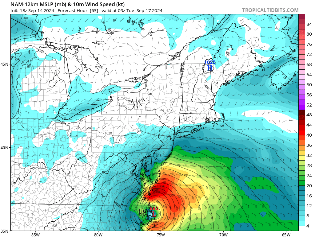
I think southeast Georgia to southwest SC. Savannah GA to Charleston SC, more specifically, highest risk. Plenty of time for changes but that’s the current high risk area for major fresh water flooding.
-
The Gulf of Maine may also be seeing more warming due to higher volumes of water via river/stream watersheds as warming climate inducing higher precipitable water in New England region. Not only is this water fresh, but it’s also a lot warmer than the Gulf of Maine. This could also be compounding the fresh water effects of melting sea ice noted above….
-
@bluewave Yes I am in agreement with that.
-
At the moment, odds are strongly in favor of significant rain threat; odds are against wind and surge threat. The scenario of a stall near Savannah GA—advertised across all major guidance and only 90 hrs out—could make a run of mill storm in terms of intensity highly impactful and, financially, very costly.
-
This is a good read. A few years old but without hyperbole. Also less “predictive”; much more of what is already occurring and why… https://www.nature.com/articles/s43247-021-00143-5 My feelings are far Western Europe (Spain, Ireland, Portugal, parts of northern/western France) and Great Britain are asymmetrically exposed to a colder climate while the eastern CONUS is asymmetrically exposed to much warmer outcomes as a result of this. The arctic Labrador current is seeing similar effects, at an even faster rate. And if the Gulf Stream were to significantly slow —what does that mean for heat transport? We then have warmer SST’s pooling in the western Atlantic, potentially up to the mid Atlantic region…Not really a prediction at this point. Seems that it’s already subtly happening…As I type this, seeing multiple buoys reporting SST’s in upper 60’s from NE MA to just south of Portland Maine. And we have another month before peaking… Fastest rate of warming in the region where the Labrador current ends its journey…fastest rate of cooling where the Gulf Stream ends its trek…
-
2024 Atlantic Hurricane Season
jbenedet replied to Stormchaserchuck1's topic in Tropical Headquarters
12zEuro and GFS show a weak disturbance developing off OBX tomorrow and hooking towards eastern LI/eastern New England Monday morning. Looks tropical, but very weak. ~1000 mb Interesting because it's immediate term and otherwise dead out there (for now)... GFS is boring evolution, and largely non-event. GEFS are more like EPS though... EPS is a little interesting...
-
Check the ASOS. Bad measurements might make you unsweat.
-
Whatever the case, the streak continues.. with CON, MHT and DAW all already achieving >/= 90...
-
Seeing CON also peaked at 90 today. The streak goes on. Days in a row 90+ DAW: 11 MHT: 10 CON: 9
-
I’m good. MHT ensuring this streak gets the recognition it deserves.
-
MHT 90 We also downslope better than MHT on west winds…
-
We roast around here. It’s generally accurate, I can say based on living and working around here. But I have seen the scatter plots from dendrite. Some skepticism is warranted for a degree or 2. I believe the bigger story is UHI affects that are concentrated along the east side of the apps and this gets fanned up from Philly, NY, the denser populated areas of CT and MA (sans Boston). It’s poorly understood (to be sure) but DAW is known to CAD on moose farts. I believe we see similarly with WAD but this ageo flow is driven by UHI. I believe the Covid migration and influx of people into northeast MA and SE NH have slightly added to this phenomenon in recent years. That’s my untested hypothesis, anyway…
-
CON also hit 90 again yesterday. current day streak 90+ DAW: 10 MHT: 9 CON: 8
-
MHT and ASH were also >90 today. MHT 92. With the next several days guidance showing high probs of >/= 90 in south/east NH, looking likely we extend the streak with an exclamation point.