Chris78
-
Posts
5,226 -
Joined
-
Last visited
Content Type
Profiles
Blogs
Forums
American Weather
Media Demo
Store
Gallery
Everything posted by Chris78
-
And neither gives us any snow lol
-
Icon is way north. Rain way up into PA
-
12z euro AI is even more suppressed lol.
-
Definitely says the OP is a further norther and warmer outlier
-
Not sure how much of the Aigfs is snow but if that's all rain with that track and the cold we've had for weeks that would be a he'll of a gut punch
-
Seems like I- 81 corridor might be the best place to be but even there it's gonna must likely flip. Of course an outcome like the Icon and its rain for everyone well up into the North East. 06z GEFS illustrates the snow chances the further NW you go
-
I hate to interrupt PSU and Chucks ongoing dissertation but the Ukie snows on us at the end of its run. Looks like it would be a snow to rain situation but looked like a thump was happening at hour 168
-
If precip makes it far enough north you guys should be in good shape up there. We're gonna need a perfect track down here and it might still not be enough.
-
Definitely threading the needle. It would need a perfect track to have a portion of the storm as snow. Imo
-
Do you think the Euro OP would of started as snow? It's about 6 to 12 hours quicker compared to 12z which may of helped.
-
It really wasn't a flush hit though. If we didn't have historic cold it would of been a big old Rainer. It amplified so far west were lucky we got any snow out of it.
-
Let's go! Time for a nice reversal today! Nice way to start out the 12z suite
-
Lol. Come on man. Gfs/cmc and Euro AI all give us snow. Still 7 days out. Long way to go
-
Cmc appears to be a modest hit.
-
I'm not sure if your actually just trying to troll or not but I'm saying this to try to be helpful to you. 99.9 % of this forum is looking for snow. It's ok to post about models that are warm or showing cutters but your also leaving out other models that are a hit or suppressed like pretty much the euro suite or even the operational Canadian. Feels like you have an agenda. There's a wide range of possibilities for next weekend but for some reason you keep harping on any model run that shows a cutter or posting 2m temp maps of 2 days after the potential storm would be over. I see that your newer here but I would suggest reading more and posting less. I was a member for years before ever posting anything. I was just reading and learning. People aren't going to be receptive if your just posting the same thing over and over again. Again not bullying you. Just giving you some feedback that I think may be helpful.
-
Only a 1500 mile differnce between Euro and Gfs. Split the difference and were in the bullseye.
-
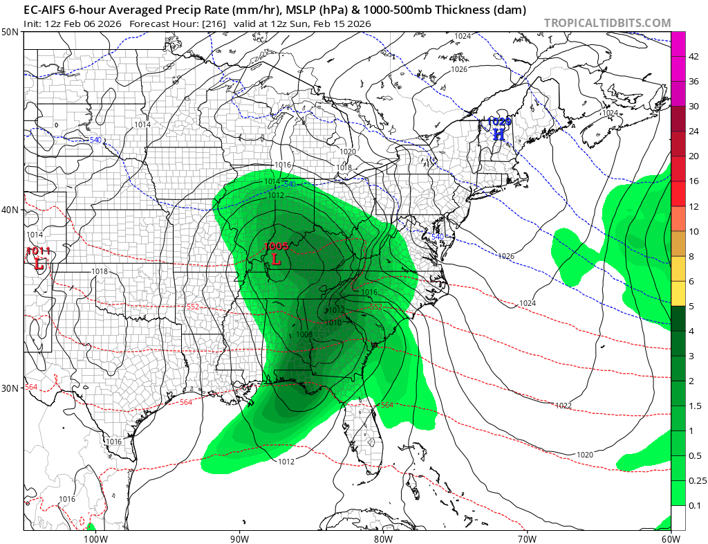
EURO AI looks real nice. It may end up being wrong buts it's certainly been consistent
-
For temps lol? Posting of a 6 hour max temp panel when the potential storm wrapped up 2 days prior doesn't really have alot to do with what type of precip the storm is going to deliver. I don't think we're on the same page as to what I was alluding to lol.
-
And the maps are from 2 days after the potential storm lol.
-
Would be interesting to see what the ground effects would be with how cold it's been. Its going to warm up a little next week but it's literally a frozen tundra out there right now. Snowing at 34 degrees after the last few weeks should have a different effect than what we normally see around these parts.
-
Looks like a rainer
-
The Euro AI looks pretty damn good I think. Temps iffy but evolution and track look awesome.

-
It actually looks alot like the Euro AI has its past several runs.
-
Talk about a thread the needle lol
-
Heading for a different result on the gfs for next weekend but not sure they'll be any cold air left