

winterwx21
-
Posts
5,152 -
Joined
-
Last visited
Content Type
Profiles
Blogs
Forums
American Weather
Media Demo
Store
Gallery
Posts posted by winterwx21
-
-
3 minutes ago, HVSnowLover said:
0Z GFS a little better than 18Z but not too exciting.
0z GFS and GGEM both showing a light snowfall for sunday. A 1 to 3 inch type of event. I would certainly take it, but hopefully it'll trend towards being a more moderate event.
-
 3
3
-
-
10 minutes ago, HeadInTheClouds said:
Models still trying to figure this out. I don't think the end result will be like either the CMC or Euro, somewhere in between possibly. I could see a scenario where coast gets 4-8 and N and W 1-3, something like that.
BTW the 12z UKMET showed a 1 to 2 inch snowfall. Yeah it's quite a model spread right now. Euro barely brushes us while GGEM is too ampted and rain. GFS in between, showing a significant snow event. Hopefully we will see an in between scenario as you mentioned. Hopefully we'll have a good idea by friday. Always seems to take awhile for the models to agree.
-
3
-
-
I just watched the color loop, and the GGEM is actually is showing rain for NYC sunday.
-
 1
1
-
-
21 minutes ago, MJO812 said:
Meh it's still winter
At least it's gonna be cold monday and tuesday. So we'd have a couple days to enjoy the snow on the ground, before the big melting midweek.
-
1
-
-
16 minutes ago, Franklin0529 said:
Cmc was a miss as well. Northern stream dont wanna play
A miss with the coastal storm, but CMC did give us a light snowfall sunday morning. About an inch. GFS tried to show a little something too.
-
13 minutes ago, Greg g said:
Any update on the 12z suite regarding the valentine day threat??
Last night's Euro hit us with some snow, but today's 12z run is out to sea. GFS and GGEM are too far to the south and east as well. Obviously still plenty of time for it to trend closer. At least there is a potential storm, and it's not bad having the models too far south and east at this early point.
-
1
-
-
The 18z run of RGEM is saying maybe we get up to an inch of snow tomorrow morning. That certainly would be nice.
-
2
-
-
43 minutes ago, Allsnow said:
Frz rain looks impactful tomorrow morning. Wouldn’t be shocked to see WWA go out
I see RGEM has it as light snow (a dusting to half inch) for us tomorrow morning, rather than freezing rain. Hopefully that will be the case.
-
2
-
-
15 minutes ago, donsutherland1 said:
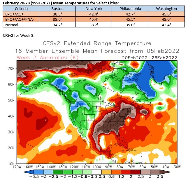
The EPS shows the development of an EPO+/AO+/PNA- pattern near February 20th. That pattern would favor warmth in the East. The CFSv2 is quite aggressive with the warmth. That’s still far enough out that it isn’t cast in stone. For now, a warm or perhaps very warm outcome is on the table, but is not yet locked in. A week from now, we’ll have a better idea of where things are going.
I always enjoy and appreciate your posts, Don.
We have a mild week coming up this week and potential for a mild late February. Sounds as if it's important to take advantage of the cold window we have coming in mid February. Cold air comes in next sunday and stays for several days. Hopefully we can get a snow event during that period.
-
3
-
-
32 degrees with snow flurries here right now. After 99% of the storm was rain, we're seeing a tiny bit of frozen precip here at the end. Pavement is just wet, but a slight glaze on the cars.
-
1
-
-
26 minutes ago, HeadInTheClouds said:
I hate the GFS but it was the only model that had me below freezing and with ZR before midnight. Every other model had it 2 to 4 hours later.
For days GFS kept insisting my area would see a horrific ice storm, but instead we ended up being all rain here. It was way off for my area. The truth for the tri-state ended up being in between GFS and the warmer models. Even though GFS overdid it, it certainly was useful since it alerted us early on that there would be an ice threat for at least part of the area.
-
3
-
-
1 minute ago, psv88 said:
Allsnow melting down, literally.
31 degrees on the island with lots of QPF to come.
Will be a very slick night out there.
I don't think we can say anyone busted or scored a victory, considering what a strange situation we have going on right now. It's not very often that NYC and parts of Long Island are below freezing with freezing rain while a good part of northern and north-central NJ is above freezing with plain rain. For part of the area it's a serious situation while for another part of the area it's a big nothing.
-
3
-
 1
1
-
-
5 minutes ago, HVSnowLover said:
Temps have crashed a lot in most of the subforum in the last several hours. Even the coast of the city is now below freezing and northern parts of the city are now in the 20s. Not sure what is going on there in terms of your temp barely dropping.
Lee Goldberg was just talking about what an unusual situation it is, with NYC below freezing while a good part of northern NJ is above freezing with plain rain. This is something we very rarely see, but some of the short range models did a good job picking up on the idea of cold air draining down into NYC but not areas just west of the city. I am still 36 with plain rain here.
-
1
-
-
51 minutes ago, Rtd208 said:
Picked up 0.56" of rain so far today.
Storm total so far 0.94"
An all plain rain event for our area. Still 37 degrees here.
-
38 minutes ago, Allsnow said:
Yeah, 7.5 here in Metuchen which is down to piles now. It’s been a poor winter for snow cover given how cold it’s been the past few weeks. Last February imo was a great month in our area. Snow cover and numerous events
We really got unlucky with that big storm earlier in January where Atlantic City got 13 inches while we got nothing. It would have been a great snow month for us had that storm hit us. Instead it was just a pretty good snow month with 2 moderate snowstorms hitting our area. I know a different story for the Jersey shore and Long Island, since they got huge amounts from that last storm.
-
3
-
-
50 degrees here right now. The warmest day we've had in a long time. A lot of melting.
-
GGEM, on the other hand, is much warmer with mainly plain rain.
-
12z Euro just came in warmer with a rain event, but obviously a long way to go.
-
1
-
-
2 minutes ago, weatherpruf said:
It's a bit frustrating to always be on that line; if it's cold enough for all snow, we're too far west. Storm comes west, we mix. Last year our totals were cut in the big storm by the sleet; Topped out at 18 but areas north did a lot better.
It definitely can be frustrating. And I am a little frustrated that we missed out on the really big totals that the Jersey shore and Long Island are getting, but I'm still happy with this storm. It's not as if we got a small advisory level event. It was a solid warning level event here. 7 inches is a significant amount of snow. Not bad at all. After missing 2 other snowstorms to the south this month, I'm glad we didn't miss out on this one.
-
1
-
-
7 minutes ago, RU848789 said:
Took a much needed nap and did some shoveling and walking around and as of 12:00 pm, we have 7.25" here in Metuchen, which was very, very hard to measure with the windblown snow, so it was probably an average of at least 20 measurements around the yard (the snowboard measurement seemed a touch high to me at 7.6") which is close to my 8.25" prediction - wasn't sure we'd get that close a few hours ago, but the mostly light snow still delivered 1/3" per hour for the last 3 hours. 19F now.
Debating what to do with the 1/4" I got yesterday in the late morning - have seen some saying to include it - if so, I got 7.5". I'm inclined to not include it, as it was from the front/clipper and we had many hours of no snow after that. Don't think we'll get more than another 1/4", looking at the radar. 7.25" seems consistent with numbers I've seen reported near me in Middelsex County here and elsewhere, such as 8.5" in Carteret, 7" in P'way, 8" in Woodbridge, 8.5" in Staten Island, and 7.5" in New Brunswick. Haven't seen any reports from Edison/Metuchen, though. Anyone?
Thanks for the update on that. Your 7.25 is just about the same as the measurement I just got here. Still coming down decently here -- high end light snow, but the back edge is getting close. I'm probably going to end up a little over 7 and a half inches. Close to what we were expecting last night.
-
1
-
-
3 minutes ago, weatherpruf said:
anyone have an update for Middlesex County NJ? A friend says around 6 in Piscataway. Too cold for me to go back out. ENjoying hot french toast and coffee. Call it brunch.
It's picking up a little bit here again as we get closer to the back edge. I think most amounts in Middlesex County will be between 6 and 8. I have a little over 7 here.
-
39 minutes ago, weatherpruf said:
I don't see how we get there, really. Is it doing much by you ? It's really anemic here in Woodbridge. Visibility is good. Just went to Shop Rite. People are out shopping. Gotta be careful but not really a big deal here. Great for the snow plow contractors. Haven't seen a municipal plow yet today.
The snowfall rates have picked up a bit here again. Low end moderate I'd say here right now. The back edge isn't too far away though. Maybe we pick up another half inch? Ending up between 7 and 8 looks reasonable but of course it varies a little from town to town. Some in Middlesex county will be closer to 6 while some get 7 to 8.
-
28 minutes ago, Will - Rutgers said:
i believe Piscataway has something like 4-6, lot of drifting
We definitely have quite a bit more than 4 considering the size of the drifts. At least 6. Measuring is very difficult obviously. I actually have us close to 7 now but it's tough to be exact. RU848789 is in Metuchen (not too far away) and he is excellent at measuring, and reported 6 and a quarter inches a couple hours ago. So I think I'm pretty close with the near 7 measurement I had a little while ago. Too bad we missed the much bigger amounts, but this is still a very nice warning level storm for our area. We have a couple more hours of snow to go too.
-
1 hour ago, weatherpruf said:
Yeah but the rates are anemic. We got what we got and 7 will be a win. Can't count the other guy's money, they say.....
It's not heavy, but a steady moderate snow. Radar actually looks pretty good. Could have a few more hours of light to moderate snow. We're approaching 7 inches now, so I think we have a good chance of getting to 8. About what we were expecting. A nice storm.
2/13 Light/Moderate Snowfall Nowcasting & Observations
in New York City Metro
Posted
12z Euro was a little better. A little accumulating light snow sunday morning. It gets about an inch up to NYC with a couple inches for central and southern NJ. The hope of seeing a moderate event is fading, but hopefully we can at least pull off a light event.